List of listed buildings in Stair, East Ayrshire
List
| Name | Location | Date Listed | Grid Ref. [note 1] | Geo-coordinates | Notes | LB Number [note 2] | Image |
|---|---|---|---|---|---|---|---|
| Stair Bridge | 55°28′48″N 4°28′25″W | Category A | 14371 |  | |||
| Stair House | 55°28′59″N 4°28′13″W | Category A | 14372 | | |||
| Crosshill Cottages | 55°29′12″N 4°24′34″W | Category C(S) | 14378 | | |||
| Schaw Church | 55°27′13″N 4°27′28″W | Category C(S) | 14376 | | |||
| Barskimming New Bridge, Including Estate Workers' Houses And Viewing Platform | 55°29′49″N 4°24′17″W | Category A | 19483 | 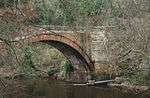 | |||
| Old Bridge Of Coyle | 55°27′26″N 4°29′35″W | Category C(S) | 14373 | | |||
| Trabbochburn | 55°28′02″N 4°25′38″W | Category C(S) | 14377 | | |||
| Old Barskimming, Sundial | 55°29′47″N 4°24′16″W | Category C(S) | 19263 | | |||
| Stair Inn, K6 Telephone Kiosk | 55°28′48″N 4°28′17″W | Category B | 19658 | | |||
| Trabboch House | 55°27′28″N 4°28′48″W | Category C(S) | 19693 | | |||
| Old Barskimming | 55°29′46″N 4°24′15″W | Category B | 19262 | | |||
| Footbridge, Tam O'shanter And Water Of Ayr Hone Works | 55°28′48″N 4°28′36″W | Category B | 14359 | 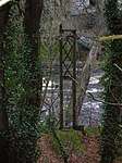 | |||
| Parish Church | 55°28′53″N 4°28′16″W | Category C(S) | 14370 | | |||
| Trabboch Castle | 55°28′07″N 4°26′25″W | Category B | 14374 | | |||
| Stairhill | 55°29′24″N 4°26′11″W | Category C(S) | 14375 | | |||
| Barskimming Old Bridge | 55°29′57″N 4°23′29″W | Category B | 14379 | |
Key
The scheme for classifying buildings in Scotland is:
- Category A: "buildings of national or international importance, either architectural or historic; or fine, little-altered examples of some particular period, style or building type."[1]
- Category B: "buildings of regional or more than local importance; or major examples of some particular period, style or building type, which may have been altered."[1]
- Category C: "buildings of local importance; lesser examples of any period, style, or building type, as originally constructed or moderately altered; and simple traditional buildings which group well with other listed buildings."[1]
In March 2016 there were 47,288 listed buildings in Scotland. Of these, 8% were Category A, and 50% were Category B, with the remaining 42% being Category C.[2]
gollark: I think my GPU is broken.
gollark: Anyway. Sane people do not store all their code in game. It's fine.
gollark: But only on boot, not dynamically like potatOS
gollark: Yep.
gollark: It's poorly and amateurishly programmed, but does auto update, and deletes all files other than itself.
Notes
- Sometimes known as OSGB36, the grid reference (where provided) is based on the British national grid reference system used by the Ordnance Survey.
• "Guide to National Grid". Ordnance Survey. Retrieved 2007-12-12.
• "Get-a-map". Ordnance Survey. Retrieved 2007-12-17. - Historic Environment Scotland assign a unique alphanumeric identifier to each designated site in Scotland, for listed buildings this always begins with "LB", for example "LB12345".
References
- All entries, addresses and coordinates are based on data from Historic Scotland. This data falls under the Open Government Licence
- "What is Listing?". Historic Environment Scotland. Retrieved 29 May 2018.
- Scotland's Historic Environment Audit 2016 (PDF). Historic Environment Scotland and the Built Environment Forum Scotland. pp. 15–16. Retrieved 29 May 2018.
This article is issued from Wikipedia. The text is licensed under Creative Commons - Attribution - Sharealike. Additional terms may apply for the media files.