List of listed buildings in Sorn, East Ayrshire
List
| Name | Location | Date Listed | Grid Ref. [note 1] | Geo-coordinates | Notes | LB Number [note 2] | Image |
|---|---|---|---|---|---|---|---|
| Sorn Castle, Turbine House | 55°30′48″N 4°18′07″W | Category C(S) | 44574 |  | |||
| 2-10 (Even Nos) Ballochmyle Street, Catrine | 55°30′19″N 4°20′06″W | Category C(S) | 43501 | | |||
| 1-13 (Odd Nos) Ford Street, Catrine | 55°30′15″N 4°19′49″W | Category C(S) | 43505 | | |||
| 16-26 (Even Nos) Mill Square, Catrine | 55°30′15″N 4°19′57″W | Category C(S) | 43508 | | |||
| 28-32 (Even Nos) Mill Square, Catrine | 55°30′14″N 4°19′54″W | Category C(S) | 43509 | | |||
| 10-14 (Even Nos) St Germain Street, Catrine | 55°30′15″N 4°19′51″W | Category C(S) | 43516 | | |||
| Catrine 2 Institute Avenue Library And Community Centre | 55°30′10″N 4°19′55″W | Category C(S) | 14268 | | |||
| Auchmannoch | 55°32′57″N 4°18′44″W | Category B | 14269 | | |||
| Daldorch | 55°30′26″N 4°19′02″W | Category B | 19680 | | |||
| Dalgain Mill | 55°30′47″N 4°17′54″W | Category C(S) | 14258 | | |||
| Sorn Castle | 55°30′52″N 4°18′04″W | Category A | 14273 | | |||
| Catrine, St Cuthbert's Street, Footbridge Over The River Ayr | 55°30′22″N 4°19′10″W | Category C(S) | 50121 | | |||
| Ballochmyle Street, Catrine, Ayr Bank House With Railings And Boundary Wall | 55°30′18″N 4°20′08″W | Category B | 43499 | | |||
| 10-14 (Even Nos) Mill Square, Catrine | 55°30′15″N 4°19′58″W | Category C(S) | 43507 | | |||
| 34-38 (Even Nos) Mill Square, Catrine | 55°30′14″N 4°19′54″W | Category C(S) | 43510 | | |||
| St Germain Street And Mill Square, Catrine, The Royal | 55°30′15″N 4°19′52″W | Category C(S) | 43513 | | |||
| 22-34 (Even Nos)St Germain Street, Including The Brewery Bar, Catrine | 55°30′14″N 4°19′47″W | Category C(S) | 43518 | | |||
| 1 Ballochmyle Street, Catrine | 55°30′18″N 4°20′07″W | Category C(S) | 43500 | | |||
| 42-46 (Even Nos) Mill Square, Catrine | 55°30′14″N 4°19′53″W | Category C(S) | 43511 | | |||
| Dalgain | 55°30′35″N 4°16′55″W | Category C(S) | 14261 | | |||
| Glenlogan | 55°30′27″N 4°16′09″W | Category B | 14262 | | |||
| Catrine Parish Church | 55°30′20″N 4°19′58″W | Category A | 14264 | 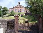 | |||
| 2 Bridge Street, Catrine | 55°30′14″N 4°19′56″W | Category C(S) | 43502 | | |||
| Mill Square And 3-5 Bridge Street, Catrine, Volunteer Arms | 55°30′14″N 4°19′55″W | Category C(S) | 43506 | | |||
| 8 St Germain Street, Catrine | 55°30′15″N 4°19′52″W | Category C(S) | 43515 | | |||
| Sorn, Entrance Lodge And Gateway | 55°30′59″N 4°18′18″W | Category B | 14256 | 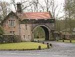 | |||
| Sorn New Bridge | 55°30′36″N 4°17′17″W | Category B | 14259 | 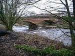 | |||
| Parish Church And Graveyard, Sorn | 55°30′47″N 4°17′51″W | Category B | 14271 | | |||
| Stables, Sorn Castle | 55°30′55″N 4°18′18″W | Category A | 14274 | | |||
| Sorn Kirkside Place Formerly The Manse | 55°30′46″N 4°17′47″W | Category C(S) | 14275 | | |||
| 4 And 8 Bridge Street, Catrine | 55°30′15″N 4°19′51″W | Category C(S) | 43503 | | |||
| 20-24 Mill Street, Catrine, The Old Mill Inn | 55°30′18″N 4°20′02″W | Category C(S) | 43512 | | |||
| 16-20 (Even Nos) St Germain Street, Catrine | 55°30′15″N 4°19′50″W | Category C(S) | 43517 | | |||
| Burnside Cottage | 55°31′08″N 4°19′31″W | Category B | 14266 | | |||
| Gilmilnscroft | 55°30′07″N 4°16′55″W | Category B | 14270 | | |||
| Catrine Village, St. Germain Street Nether Catrine House | 55°30′13″N 4°19′41″W | Category B | 14276 | | |||
| 40 Mill Square | 55°30′14″N 4°19′53″W | Category C(S) | 51098 | | |||
| 11-12 Bridge Street, Catrine | 55°30′13″N 4°19′55″W | Category C(S) | 43504 | | |||
| Sorn Castle, East Gatehouse, Cleuch Cottage | 55°30′53″N 4°17′57″W | Category B | 19666 | | |||
| No. 1 Ladeside Cottage | 55°30′47″N 4°17′54″W | Category C(S) | 14257 | | |||
| Bridge Over River Ayr, Opposite Sorn Parish Church | 55°30′46″N 4°17′54″W | Category A | 14272 | 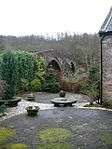 | |||
| St Germain Street, Catrine, The Royal Bank Of Scotland With Boundary Walls | 55°30′16″N 4°19′52″W | Category C(S) | 43514 | | |||
| Sawmill Cottage And Gatepiers | 55°30′57″N 4°18′34″W | Category C(S) | 19681 | | |||
| Nethershield Farmhouse And Steading | 55°30′53″N 4°14′34″W | Category B | 19258 | | |||
| School, Sorn | 55°30′38″N 4°17′31″W | Category B | 14260 | | |||
| Stables, Daldorch | 55°30′23″N 4°19′07″W | Category B | 14263 | |
Key
The scheme for classifying buildings in Scotland is:
- Category A: "buildings of national or international importance, either architectural or historic; or fine, little-altered examples of some particular period, style or building type."[1]
- Category B: "buildings of regional or more than local importance; or major examples of some particular period, style or building type, which may have been altered."[1]
- Category C: "buildings of local importance; lesser examples of any period, style, or building type, as originally constructed or moderately altered; and simple traditional buildings which group well with other listed buildings."[1]
In March 2016 there were 47,288 listed buildings in Scotland. Of these, 8% were Category A, and 50% were Category B, with the remaining 42% being Category C.[2]
gollark: You realize it *is* 2022, right?
gollark: Except the bad physics one.
gollark: I wrote all of them then shipped them to you.
gollark: 7 weeks.
gollark: Too obvious. Why would they make it that clear?
Notes
- Sometimes known as OSGB36, the grid reference (where provided) is based on the British national grid reference system used by the Ordnance Survey.
• "Guide to National Grid". Ordnance Survey. Retrieved 2007-12-12.
• "Get-a-map". Ordnance Survey. Retrieved 2007-12-17. - Historic Environment Scotland assign a unique alphanumeric identifier to each designated site in Scotland, for listed buildings this always begins with "LB", for example "LB12345".
References
- All entries, addresses and coordinates are based on data from Historic Scotland. This data falls under the Open Government Licence
- "What is Listing?". Historic Environment Scotland. Retrieved 29 May 2018.
- Scotland's Historic Environment Audit 2016 (PDF). Historic Environment Scotland and the Built Environment Forum Scotland. pp. 15–16. Retrieved 29 May 2018.
This article is issued from Wikipedia. The text is licensed under Creative Commons - Attribution - Sharealike. Additional terms may apply for the media files.