List of listed buildings in Scoonie, Fife
List
| Name | Location | Date Listed | Grid Ref. [note 1] | Geo-coordinates | Notes | LB Number [note 2] | Image |
|---|---|---|---|---|---|---|---|
| Durie Policies, Durie Ice House | 56°12′43″N 3°00′45″W | Category C(S) | 16700 |  | |||
| Kilmux House | 56°13′55″N 3°01′26″W | Category B | 16702 | | |||
| Silverburn House Estate, Cottages, Nos 1, 2, And 3 | 56°12′24″N 2°58′42″W | Category C(S) | 16703 | | |||
| Drummaird Farmhouse, Steading And Boundary Walls | 56°13′08″N 3°01′59″W | Category C(S) | 46483 | | |||
| Burnside Of Letham Including Watermill With Wheel And Steading | 56°13′31″N 3°01′03″W | Category B | 49899 | | |||
| Durie House With Court Of Offices, Sundial And Walled Garden | 56°12′43″N 3°00′43″W | Category A | 16699 | 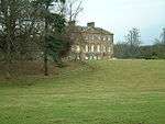 | |||
| Kilmux Farm Steading | 56°14′00″N 3°01′20″W | Category B | 46485 | | |||
| Silverburn House Estate, Corriemar | 56°12′21″N 2°58′56″W | Category C(S) | 16680 | | |||
| Kilmux Lodge House With Boundary Walls | 56°13′51″N 3°01′31″W | Category C(S) | 46487 | | |||
| Kilmux Farmhouse With Boundary Walls | 56°14′01″N 3°01′17″W | Category B | 46484 | | |||
| Kilmux House, Walled Garden | 56°13′56″N 3°01′22″W | Category C(S) | 46486 | | |||
| Montrave Home Farm, Montrave Doocot | 56°14′55″N 3°00′18″W | Category B | 42444 | | |||
| Silverburn House Estate, Offices Including Gatepiers | 56°12′22″N 2°58′43″W | Category B | 16679 | | |||
| Durie Home Farm, Durie Dovecot | 56°12′36″N 3°00′57″W | Category B | 16701 | |
Key
The scheme for classifying buildings in Scotland is:
- Category A: "buildings of national or international importance, either architectural or historic; or fine, little-altered examples of some particular period, style or building type."[1]
- Category B: "buildings of regional or more than local importance; or major examples of some particular period, style or building type, which may have been altered."[1]
- Category C: "buildings of local importance; lesser examples of any period, style, or building type, as originally constructed or moderately altered; and simple traditional buildings which group well with other listed buildings."[1]
In March 2016 there were 47,288 listed buildings in Scotland. Of these, 8% were Category A, and 50% were Category B, with the remaining 42% being Category C.[2]
gollark: They should really have not done that.
gollark: baud != bitrate, bee.
gollark: Title Case Is Quite Apiaristic.
gollark: In One Terry Pratchett Discworld Book, It Was Used For Golem Speech, And Made More Sense There.
gollark: That Sounds Quite Annoying.
See also
Notes
- Sometimes known as OSGB36, the grid reference (where provided) is based on the British national grid reference system used by the Ordnance Survey.
• "Guide to National Grid". Ordnance Survey. Retrieved 2007-12-12.
• "Get-a-map". Ordnance Survey. Retrieved 2007-12-17. - Historic Environment Scotland assign a unique alphanumeric identifier to each designated site in Scotland, for listed buildings this always begins with "LB", for example "LB12345".
References
- All entries, addresses and coordinates are based on data from Historic Scotland. This data falls under the Open Government Licence
- "What is Listing?". Historic Environment Scotland. Retrieved 29 May 2018.
- Scotland's Historic Environment Audit 2016 (PDF). Historic Environment Scotland and the Built Environment Forum Scotland. pp. 15–16. Retrieved 29 May 2018.
This article is issued from Wikipedia. The text is licensed under Creative Commons - Attribution - Sharealike. Additional terms may apply for the media files.