List of listed buildings in Saltoun, East Lothian
List
| Name | Location | Date Listed | Grid Ref. [note 1] | Geo-coordinates | Notes | LB Number [note 2] | Image |
|---|---|---|---|---|---|---|---|
| West Saltoun, Main Street, Thornylee Cottage | 55°53′46″N 2°51′50″W | Category C(S) | 18905 |  | |||
| West Saltoun, Milton Bridge, Barley Mill | 55°53′25″N 2°52′01″W | Category B | 18906 | | |||
| West Saltoun, Milton Bridge, Barley Mill House With Outbuildings And Retaining Walls | 55°53′25″N 2°52′05″W | Category B | 18907 | | |||
| East Saltoun, Main Street, 1, 2 And 3 Saltoun Cottages | 55°54′03″N 2°50′27″W | Category C(S) | 18882 | | |||
| East Saltoun, 4-9 (Inclusive) Main Street | 55°54′01″N 2°50′26″W | Category C(S) | 18883 | | |||
| Saltoun Hall, South Lodge With Quadrant Walls, Gatepiers And Gates | 55°54′15″N 2°51′28″W | Category B | 18897 | | |||
| East Mains Cartshed And Granary With Cottage | 55°54′38″N 2°49′48″W | Category C(S) | 18876 | | |||
| East Mains Farmhouse | 55°54′37″N 2°49′48″W | Category C(S) | 18877 | | |||
| East Saltoun, Old Castle With Retaining Walls | 55°54′06″N 2°50′31″W | Category B | 18884 | | |||
| Herdmanston Chapel | 55°55′07″N 2°50′49″W | Category B | 18890 | | |||
| Herdmanston Dovecot | 55°55′12″N 2°50′53″W | Category B | 18891 | | |||
| West Saltoun,1 And 2 The Kennels (Former Fletcher Dower House) | 55°53′50″N 2°51′46″W | Category B | 18903 | | |||
| Saltoun Home Farm With Retaining Walls And Piers | 55°54′35″N 2°51′26″W | Category B | 19112 | | |||
| East Saltoun Farmhouse | 55°54′05″N 2°50′27″W | Category C(S) | 18879 | | |||
| Gilchriston Farmhouse | 55°52′39″N 2°49′50″W | Category B | 18889 | | |||
| Saltoun Hall With Terrace Wall And Enclousure | 55°54′22″N 2°51′51″W | Category A | 18895 | 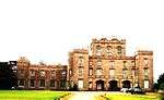 | |||
| East Saltoun, Elmbank And Walney With Retaining Wall | 55°54′08″N 2°50′33″W | Category B | 18878 | | |||
| East Saltoun, Fountain Cottage | 55°54′02″N 2°50′28″W | Category C(S) | 18881 | | |||
| Middlemains Farmhouse | 55°54′34″N 2°50′54″W | Category B | 18893 | | |||
| Middlemains Lime Kilns | 55°54′46″N 2°50′42″W | Category B | 18894 | | |||
| Saltoun Hall, North Lodges | 55°54′39″N 2°51′57″W | Category C(S) | 18898 | | |||
| Saltoun Hall Stables,Carriage House And Cistern-Head | 55°54′19″N 2°51′41″W | Category A | 18899 | | |||
| West Blance Farmhouse | 55°54′33″N 2°49′06″W | Category B | 18902 | | |||
| East Saltoun Fletcher Memorial Fountain | 55°54′03″N 2°50′29″W | Category B | 18880 | | |||
| East Saltoun, Saltoun Hill (Former Manse) With Gates, Gatepiers And Retaining Walls | 55°54′02″N 2°50′23″W | Category B | 18886 | | |||
| East Saltoun, Smithy | 55°53′58″N 2°50′22″W | Category C(S) | 18887 | | |||
| Saltoun Hall, Garden Cottage | 55°54′36″N 2°52′09″W | Category B | 18896 | | |||
| Herdmanston Steading | 55°55′10″N 2°50′42″W | Category B | 18892 | | |||
| West Saltoun, Main Street, Coruisk | 55°53′46″N 2°51′50″W | Category C(S) | 18904 | | |||
| East Saltoun Parish Church With Graveyard Walls And Railings | 55°54′04″N 2°50′31″W | Category A | 18885 | | |||
| Saltoun Hall, Walled Garden | 55°54′33″N 2°52′12″W | Category B | 18900 | | |||
| Spilmersford Bridge | 55°54′40″N 2°52′00″W | Category C(S) | 18901 | |
Key
The scheme for classifying buildings in Scotland is:
- Category A: "buildings of national or international importance, either architectural or historic; or fine, little-altered examples of some particular period, style or building type."[1]
- Category B: "buildings of regional or more than local importance; or major examples of some particular period, style or building type, which may have been altered."[1]
- Category C: "buildings of local importance; lesser examples of any period, style, or building type, as originally constructed or moderately altered; and simple traditional buildings which group well with other listed buildings."[1]
In March 2016 there were 47,288 listed buildings in Scotland. Of these, 8% were Category A, and 50% were Category B, with the remaining 42% being Category C.[2]
gollark: * would be
gollark: Which is unreasonable of you.
gollark: Which they fixed.
gollark: Wait, why am I even saying "your" bugs?
gollark: You haven't really not hoarded all your other bugs.
Notes
- Sometimes known as OSGB36, the grid reference (where provided) is based on the British national grid reference system used by the Ordnance Survey.
• "Guide to National Grid". Ordnance Survey. Retrieved 2007-12-12.
• "Get-a-map". Ordnance Survey. Retrieved 2007-12-17. - Historic Environment Scotland assign a unique alphanumeric identifier to each designated site in Scotland, for listed buildings this always begins with "LB", for example "LB12345".
References
- All entries, addresses and coordinates are based on data from Historic Scotland. This data falls under the Open Government Licence
- "What is Listing?". Historic Environment Scotland. Retrieved 29 May 2018.
- Scotland's Historic Environment Audit 2016 (PDF). Historic Environment Scotland and the Built Environment Forum Scotland. pp. 15–16. Retrieved 29 May 2018.
This article is issued from Wikipedia. The text is licensed under Creative Commons - Attribution - Sharealike. Additional terms may apply for the media files.