List of listed buildings in Rosneath, Argyll and Bute
List
| Name | Location | Date Listed | Grid Ref. [note 1] | Geo-coordinates | Notes | LB Number [note 2] | Image |
|---|---|---|---|---|---|---|---|
| Shore Road, Carloch With Boundary Walls And Gatepiers | 56°04′24″N 4°50′21″W | Category C(S) | 42641 |  | |||
| Clynder, Back Road, Glenavon | 56°01′13″N 4°48′55″W | Category C(S) | 42618 | | |||
| Clynder, Shore Road, Former Coach House To Achnashie | 56°00′50″N 4°48′29″W | Category C(S) | 42619 | | |||
| Clynder, Shore Road, Bonaln | 56°01′18″N 4°48′54″W | Category B | 42620 | | |||
| Rosneath Castle Estate, Gallowhill, Well House | 55°59′32″N 4°47′35″W | Category C(S) | 42629 | | |||
| Rosneath Village, 1-4 (Inclusive) Clachan Bridge | 56°00′37″N 4°48′07″W | Category C(S) | 42632 | | |||
| Shore Road, Aikenshaw With Service Block | 56°02′49″N 4°50′10″W | Category B | 42637 | | |||
| Shore Road, Glenard | 56°04′27″N 4°50′25″W | Category C(S) | 42643 | | |||
| Shore Road, Loch-Na-Brae | 56°03′32″N 4°50′33″W | Category C(S) | 42645 | | |||
| Barremman Farm With Steading, Coachhouse And Stables | 56°01′43″N 4°49′24″W | Category B | 42617 | | |||
| Gareloch House With Retaining And Boundary Walls And Gatepiers | 56°00′51″N 4°48′31″W | Category A | 42621 | | |||
| Portkil, Former Coach Master's House And Coach House | 55°59′18″N 4°48′16″W | Category C(S) | 42624 | | |||
| Rosneath Village, The Old Manse | 56°00′32″N 4°48′09″W | Category C(S) | 42633 | | |||
| Rosneath Village, St Modan's Parish Church | 56°00′34″N 4°48′05″W | Category A | 42634 | 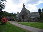 | |||
| Shore Road, Aldavhu With Boundary Walls And Gatepiers | 56°04′39″N 4°50′21″W | Category C(S) | 42638 | | |||
| Shore Road, Ardchoille With Gatepiers | 56°01′50″N 4°49′27″W | Category B | 42639 | | |||
| Rosneath Castle Estate, Bathwell (Near Parkhead) | 55°59′56″N 4°47′07″W | Category A | 42625 | | |||
| Rosneath Point, Ferry Inn | 56°00′43″N 4°47′46″W | Category A | 42630 | | |||
| Portkil Cottage | 55°59′17″N 4°48′17″W | Category C(S) | 42623 | | |||
| Shore Road, Dahlandhui Hotel With Gazebo, Stables, Boundary Wall And Gatepiers | 56°04′22″N 4°50′19″W | Category B | 42642 | | |||
| Shore Road, Glengair | 56°01′54″N 4°49′30″W | Category B | 42644 | | |||
| Rosneath Point, Ferry Inn Cottage | 56°00′43″N 4°47′48″W | Category C(S) | 42631 | | |||
| Rosneath Village, No (Former Police Station) | 56°00′37″N 4°48′06″W | Category B | 42635 | | |||
| Rosneath Village, St Modan's Old Church With Graveyard And Boundary Walls | 56°00′33″N 4°48′11″W | Category B | 42636 | | |||
| Barbour Road, Knockderry Farm Steading And Farmhouse | 56°00′31″N 4°50′50″W | Category C(S) | 42616 | | |||
| Rosneath Castle Estate, Ice House | 56°00′00″N 4°46′59″W | Category C(S) | 42626 | | |||
| Rosneath Castle Estate, Parkhead With Walled Garden | 55°59′53″N 4°46′55″W | Category C(S) | 42627 | | |||
| Rosneath Castle Estate, Rosneath Home Farm | 55°59′39″N 4°46′56″W | Category A | 42628 | 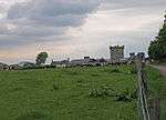 | |||
| Shore Road, Stroul Lodge | 56°00′59″N 4°48′43″W | Category B | 42647 | | |||
| Millbrae, Camsail House (Former Free Church Manse) | 55°59′50″N 4°48′15″W | Category C(S) | 42622 | | |||
| Shore Road, Loch-Na-Gare | 56°02′57″N 4°50′15″W | Category C(S) | 42646 | |
Key
The scheme for classifying buildings in Scotland is:
- Category A: "buildings of national or international importance, either architectural or historic; or fine, little-altered examples of some particular period, style or building type."[1]
- Category B: "buildings of regional or more than local importance; or major examples of some particular period, style or building type, which may have been altered."[1]
- Category C: "buildings of local importance; lesser examples of any period, style, or building type, as originally constructed or moderately altered; and simple traditional buildings which group well with other listed buildings."[1]
In March 2016 there were 47,288 listed buildings in Scotland. Of these, 8% were Category A, and 50% were Category B, with the remaining 42% being Category C.[2]
gollark: Do you know how prime factors work?
gollark: (I mean, cool people™ just have their computer do it instead of factoring it by hand)
gollark: Instead of not doing maths, do maths.
gollark: The two factors of the number it gives you.
gollark: Semiprime factorization is not too complex.
Notes
- Sometimes known as OSGB36, the grid reference (where provided) is based on the British national grid reference system used by the Ordnance Survey.
• "Guide to National Grid". Ordnance Survey. Retrieved 2007-12-12.
• "Get-a-map". Ordnance Survey. Retrieved 2007-12-17. - Historic Environment Scotland assign a unique alphanumeric identifier to each designated site in Scotland, for listed buildings this always begins with "LB", for example "LB12345".
References
- All entries, addresses and coordinates are based on data from Historic Scotland. This data falls under the Open Government Licence
- "What is Listing?". Historic Environment Scotland. Retrieved 29 May 2018.
- Scotland's Historic Environment Audit 2016 (PDF). Historic Environment Scotland and the Built Environment Forum Scotland. pp. 15–16. Retrieved 29 May 2018.
This article is issued from Wikipedia. The text is licensed under Creative Commons - Attribution - Sharealike. Additional terms may apply for the media files.