List of listed buildings in Rescobie, Angus
List
| Name | Location | Date Listed | Grid Ref. [note 1] | Geo-coordinates | Notes | LB Number [note 2] | Image |
|---|---|---|---|---|---|---|---|
| Balmadies - North Lodge Gates | 56°38′35″N 2°44′02″W | Category B | 17667 |  | |||
| Chapelton - Burial Ground | 56°38′45″N 2°45′03″W | Category B | 17671 | | |||
| Guthrie Castle - West Lodge | 56°38′29″N 2°43′12″W | Category B | 17673 | | |||
| Carse Gray House | 56°40′22″N 2°52′32″W | Category B | 17676 | 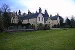 | |||
| Guthrie Castle - Icehouse | 56°38′35″N 2°43′15″W | Category B | 17675 | | |||
| North Mains Of Turin - Doocot | 56°40′02″N 2°46′10″W | Category B | 17677 | | |||
| Kirkyard Walls | 56°39′27″N 2°48′07″W | Category B | 17679 | | |||
| Manse - Gatepiers | 56°39′29″N 2°48′10″W | Category C(S) | 17681 | | |||
| Burnside House | 56°38′23″N 2°48′53″W | Category C(S) | 17686 | | |||
| Burnside - Doocot | 56°38′21″N 2°48′55″W | Category B | 17687 | | |||
| Burnside Bridge Over Burnside Burn | 56°38′21″N 2°49′37″W | Category C(S) | 19816 | | |||
| Balmadies - Bridge Over The Holms | 56°38′26″N 2°43′59″W | Category B | 17665 | | |||
| Milldens Of Balmadies Farmhouse | 56°38′38″N 2°44′19″W | Category B | 17672 | | |||
| Rescobie Parish Kirk | 56°39′27″N 2°48′07″W | Category B | 17678 | 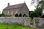 | |||
| Manse - Offices | 56°39′28″N 2°48′08″W | Category C(S) | 17682 | | |||
| Reswallie House | 56°39′10″N 2°48′39″W | Category B | 19815 | | |||
| Pitscandly House | 56°39′42″N 2°50′35″W | Category A | 17657 | | |||
| Pitscandly - Sundial (1) | 56°39′41″N 2°50′36″W | Category C(S) | 17658 | | |||
| Pitscandly - Sundial (2) | 56°39′42″N 2°50′36″W | Category C(S) | 17660 | | |||
| Balmadies - Stable Gatepiers | 56°38′15″N 2°43′59″W | Category B | 17664 | | |||
| Balmadies - Birkward Croft | 56°38′07″N 2°45′02″W | Category C(S) | 17669 | | |||
| "The Old Toll House" Clocksbriggs | 56°39′23″N 2°48′42″W | Category C(S) | 17683 | | |||
| Reswallie - West Lodge Gates | 56°39′08″N 2°48′47″W | Category B | 17685 | | |||
| Pitscandly - Walled Garden | 56°39′42″N 2°50′31″W | Category C(S) | 17659 | | |||
| Balmadies House | 56°38′13″N 2°43′51″W | Category B | 17662 | | |||
| Balmadies - Red Lodge | 56°38′08″N 2°45′02″W | Category B | 17668 | | |||
| Guthrie Castle - West Gate | 56°38′29″N 2°43′13″W | Category B | 17674 | | |||
| Reswallie - West Lodge | 56°39′09″N 2°48′47″W | Category B | 17684 | | |||
| Balmadies - Mains Farmhouse | 56°38′13″N 2°44′09″W | Category C(S) | 19813 | | |||
| Balmadies - Stables | 56°38′15″N 2°43′59″W | Category B | 17663 | | |||
| Chapelton Farmhouse | 56°38′26″N 2°45′14″W | Category B | 17670 | | |||
| Carse Gray - Sundial | 56°40′20″N 2°52′31″W | Category B | 19814 | | |||
| Pitscandly - Doocot | 56°39′41″N 2°50′32″W | Category B | 17661 | | |||
| Balmadies - North Lodge | 56°38′34″N 2°44′02″W | Category B | 17666 | | |||
| Former Parish Kirk Manse | 56°39′29″N 2°48′10″W | Category C(S) | 17680 | |
Key
The scheme for classifying buildings in Scotland is:
- Category A: "buildings of national or international importance, either architectural or historic; or fine, little-altered examples of some particular period, style or building type."[1]
- Category B: "buildings of regional or more than local importance; or major examples of some particular period, style or building type, which may have been altered."[1]
- Category C: "buildings of local importance; lesser examples of any period, style, or building type, as originally constructed or moderately altered; and simple traditional buildings which group well with other listed buildings."[1]
In March 2016 there were 47,288 listed buildings in Scotland. Of these, 8% were Category A, and 50% were Category B, with the remaining 42% being Category C.[2]
gollark: Also, sandboxing.
gollark: The trick is to use Linux & not randomly download from the internet.
gollark: Indeed it is not.
gollark: ~~Linux and sanity!~~
gollark: * better wipe than (hopefully) fix
See also
Notes
- Sometimes known as OSGB36, the grid reference (where provided) is based on the British national grid reference system used by the Ordnance Survey.
• "Guide to National Grid". Ordnance Survey. Retrieved 2007-12-12.
• "Get-a-map". Ordnance Survey. Retrieved 2007-12-17. - Historic Environment Scotland assign a unique alphanumeric identifier to each designated site in Scotland, for listed buildings this always begins with "LB", for example "LB12345".
References
- All entries, addresses and coordinates are based on data from Historic Scotland. This data falls under the Open Government Licence
- "What is Listing?". Historic Environment Scotland. Retrieved 29 May 2018.
- Scotland's Historic Environment Audit 2016 (PDF). Historic Environment Scotland and the Built Environment Forum Scotland. pp. 15–16. Retrieved 29 May 2018.
This article is issued from Wikipedia. The text is licensed under Creative Commons - Attribution - Sharealike. Additional terms may apply for the media files.