List of listed buildings in Prestonkirk, East Lothian
List
| Name | Location | Date Listed | Grid Ref. [note 1] | Geo-coordinates | Notes | LB Number [note 2] | Image |
|---|---|---|---|---|---|---|---|
| Phantassie Limekiln | 55°58′59″N 2°38′23″W | Category B | 14504 |  | |||
| Crauchie Farm Steading | 55°59′49″N 2°42′06″W | Category B | 14511 | | |||
| Hailes Smithy | 55°58′23″N 2°40′51″W | Category C(S) | 14518 | | |||
| Scotscraig | 55°58′58″N 2°39′18″W | Category B | 14520 | | |||
| Houston Mill | 55°59′26″N 2°39′13″W | Category B | 18965 | | |||
| Cauldside Cottage With Ingleneuk | 56°00′09″N 2°39′20″W | Category B | 18188 | | |||
| Phantassie Cottages | 55°59′06″N 2°39′12″W | Category B | 14500 | | |||
| Phantassie Dovecot | 55°59′16″N 2°38′52″W | Category A | 14501 | 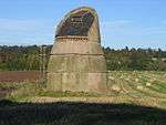 | |||
| Drylawhill Farm | 55°59′36″N 2°39′52″W | Category B | 14515 | | |||
| Markle Mains Farm Steading | 55°59′15″N 2°42′07″W | Category B | 14498 | | |||
| Phantassie Farm Steading | 55°59′10″N 2°38′54″W | Category B | 14502 | | |||
| Preston Mains Farmhouse | 55°59′42″N 2°38′44″W | Category B | 14505 | | |||
| Crauchie Farm Cottages | 55°59′46″N 2°42′14″W | Category B | 14512 | | |||
| Traprain Farmhouse With Garden Walls And Gatepiers | 55°58′22″N 2°39′22″W | Category C(S) | 14527 | | |||
| Crauchie Farmhouse With Retaining Wall And Gatepiers | 55°59′48″N 2°42′06″W | Category B | 14513 | | |||
| Sunnyside Cottages | 55°58′17″N 2°39′18″W | Category B | 14524 | | |||
| Waughton Dovecot | 56°01′05″N 2°41′46″W | Category B | 14529 | | |||
| Phantassie House | 55°59′11″N 2°38′45″W | Category A | 14503 | | |||
| Beanston House | 55°58′38″N 2°43′29″W | Category B | 14506 | | |||
| Hailes Castle | 55°58′24″N 2°41′00″W | Category A | 14516 | | |||
| Smeaton-Hepburn Gate Lodge | 55°59′31″N 2°39′14″W | Category B | 14522 | | |||
| Smeaton-Hepburn Farm Steading East Range | 56°00′00″N 2°39′09″W | Category B | 14523 | | |||
| Sunnyside Farm Steading And Stalk | 55°58′13″N 2°39′05″W | Category B | 14526 | | |||
| Prestonkirk Parish Church (Church Of Scotland) | 55°59′29″N 2°39′17″W | Category A | 14530 | | |||
| Beanston Orangery | 55°58′38″N 2°43′24″W | Category B | 14507 | | |||
| Beanston Steading And Stalk | 55°58′39″N 2°43′42″W | Category B | 14508 | | |||
| Smeaton-Hepburn Garden Walls And Sundials | 55°59′54″N 2°39′07″W | Category B | 14521 | | |||
| Traprain Steading And Stalk | 55°58′24″N 2°39′17″W | Category C(S) | 14528 | | |||
| Preston Mill | 55°59′32″N 2°39′04″W | Category A | 14531 | 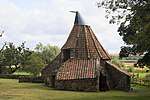 | |||
| Brownrigg Farmhouse | 56°01′03″N 2°43′05″W | Category B | 14510 | | |||
| Drylawhill Dovecot | 55°59′36″N 2°39′56″W | Category B | 14514 | | |||
| Hailes Cottage | 55°58′21″N 2°40′55″W | Category C(S) | 14517 | | |||
| Sandy's Mill | 55°58′07″N 2°43′20″W | Category A | 14519 | 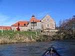 | |||
| Markle Mains Farmhouse With Retaining Walls, Gatepiers And Wrought-Iron Gates | 55°59′17″N 2°42′02″W | Category B | 14497 | | |||
| Overhailes Farmhouse | 55°58′40″N 2°41′15″W | Category B | 14499 | | |||
| Beanston Walled Garden | 55°58′40″N 2°43′22″W | Category C(S) | 14509 | | |||
| Sunnyside Farmhouse | 55°58′14″N 2°39′04″W | Category B | 14525 | |
Key
The scheme for classifying buildings in Scotland is:
- Category A: "buildings of national or international importance, either architectural or historic; or fine, little-altered examples of some particular period, style or building type."[1]
- Category B: "buildings of regional or more than local importance; or major examples of some particular period, style or building type, which may have been altered."[1]
- Category C: "buildings of local importance; lesser examples of any period, style, or building type, as originally constructed or moderately altered; and simple traditional buildings which group well with other listed buildings."[1]
In March 2016 there were 47,288 listed buildings in Scotland. Of these, 8% were Category A, and 50% were Category B, with the remaining 42% being Category C.[2]
gollark: ... what do you mean "HWID"?
gollark: A what?
gollark: 😃? <:smiles:725046901174567103>?
gollark: So you can have snake bracelets and necklaces, but what other jewelry can snakes replicate?
gollark: and/or parasite/leech.
Notes
- Sometimes known as OSGB36, the grid reference (where provided) is based on the British national grid reference system used by the Ordnance Survey.
• "Guide to National Grid". Ordnance Survey. Retrieved 2007-12-12.
• "Get-a-map". Ordnance Survey. Retrieved 2007-12-17. - Historic Environment Scotland assign a unique alphanumeric identifier to each designated site in Scotland, for listed buildings this always begins with "LB", for example "LB12345".
References
- All entries, addresses and coordinates are based on data from Historic Scotland. This data falls under the Open Government Licence
- "What is Listing?". Historic Environment Scotland. Retrieved 29 May 2018.
- Scotland's Historic Environment Audit 2016 (PDF). Historic Environment Scotland and the Built Environment Forum Scotland. pp. 15–16. Retrieved 29 May 2018.
This article is issued from Wikipedia. The text is licensed under Creative Commons - Attribution - Sharealike. Additional terms may apply for the media files.