List of listed buildings in Portsoy, Aberdeenshire
List
| Name | Location | Date Listed | Grid Ref. [note 1] | Geo-coordinates | Notes | LB Number [note 2] | Image |
|---|---|---|---|---|---|---|---|
| 45 Seafield Street And Pend Arch To Commercial Hotel | 57°40′54″N 2°41′14″W | Category C(S) | 40276 |  | |||
| 13 Seafield Terrace, Nile Cottage | 57°40′49″N 2°41′41″W | Category B | 40285 | | |||
| 40 South High Street | 57°40′58″N 2°41′30″W | Category C(S) | 40307 | | |||
| 18, 19 The Square | 57°40′59″N 2°41′28″W | Category C(S) | 40313 | | |||
| 18 Barbank Street | 57°41′04″N 2°41′31″W | Category C(S) | 40216 | | |||
| 9 Burnside And Garden Walls | 57°40′58″N 2°41′25″W | Category C(S) | 40218 | | |||
| 3 Church Street | 57°40′54″N 2°41′17″W | Category C(S) | 40219 | | |||
| 15, 17, 19 Church Street | 57°40′55″N 2°41′18″W | Category B | 40220 | | |||
| 1 Main Street | 57°41′07″N 2°41′16″W | Category C(S) | 40252 | | |||
| 8 Main Street | 57°41′06″N 2°41′16″W | Category C(S) | 40257 | | |||
| 5, 7 North High Street And Rear Garden Walls | 57°41′01″N 2°41′29″W | Category B | 40261 | | |||
| 23, 25 And 27 North High Street And Rear Garden Walls | 57°41′02″N 2°41′29″W | Category A | 40262 | | |||
| 2 North High Street, The Boyne Hotel | 57°41′01″N 2°41′28″W | Category C(S) | 40264 | | |||
| 12 North High Street | 57°41′02″N 2°41′28″W | Category B | 40267 | | |||
| 22, 24 Seafield Street, 2 Roseacre Street | 57°40′53″N 2°41′25″W | Category C(S) | 40278 | | |||
| 18, 20 Shillinghill | 57°40′56″N 2°41′21″W | Category B | 40286 | | |||
| 22 Shillinghill And Front Garden | 57°40′56″N 2°41′20″W | Category B | 40287 | | |||
| 6, 7 Shorehead | 57°41′04″N 2°41′29″W | Category B | 40289 | | |||
| 9 Shorehead | 57°41′05″N 2°41′29″W | Category B | 40290 | | |||
| Shorehead, Old Co-Operative Grain Store | 57°41′07″N 2°41′30″W | Category B | 40295 | 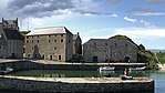 | |||
| 24 The Square | 57°40′58″N 2°41′28″W | Category C(S) | 40314 | | |||
| 5 Wood Street | 57°41′07″N 2°41′15″W | Category C(S) | 40319 | | |||
| 28-32 Church Street, Cottage To Rear | 57°40′58″N 2°41′18″W | Category C(S) | 40224 | | |||
| 52, 54 Church Street | 57°41′01″N 2°41′22″W | Category C(S) | 40229 | | |||
| 56 Church Street And Rear Cottage | 57°41′01″N 2°41′22″W | Category C(S) | 40230 | | |||
| 40 Cullen Street And Rear Garden Wall | 57°41′00″N 2°41′42″W | Category C(S) | 40241 | | |||
| 3 Institute Street | 57°40′58″N 2°41′19″W | Category C(S) | 40244 | | |||
| 5 Institute Street | 57°40′58″N 2°41′18″W | Category C(S) | 40245 | | |||
| Lodging Brae, 1, 2, 3, 4 Old Coastguards Houses | 57°41′04″N 2°41′21″W | Category C(S) | 40246 | | |||
| 31, 33 Low Street | 57°41′04″N 2°41′27″W | Category B | 40251 | | |||
| 4 Main Street | 57°41′07″N 2°41′16″W | Category C(S) | 40255 | | |||
| 4 North High Street | 57°41′01″N 2°41′28″W | Category B | 40265 | | |||
| 22, 24 North High Street | 57°41′03″N 2°41′27″W | Category B | 40269 | | |||
| 26 North High Street | 57°41′04″N 2°41′27″W | Category B | 40270 | | |||
| 1, 3 Seafield Street | 57°40′54″N 2°41′32″W | Category C(S) | 40274 | | |||
| 4 Seafield Terrace, Church Of Scotland Manse | 57°40′52″N 2°41′40″W | Category B | 40283 | | |||
| Shore Street, New Harbour | 57°41′10″N 2°41′19″W | Category B | 40298 | 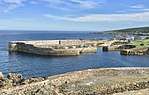 | |||
| 17, 19, 21 South High Street | 57°40′55″N 2°41′32″W | Category C(S) | 40300 | | |||
| 47 South High Street, Clydesdale Bank | 57°40′58″N 2°41′32″W | Category C(S) | 40303 | | |||
| 14 South High Street | 57°40′55″N 2°41′31″W | Category C(S) | 40305 | | |||
| St Comb's Road, Old Lifeboat House | 57°40′57″N 2°41′06″W | Category B | 40309 | | |||
| 13, 14 The Square | 57°41′00″N 2°41′30″W | Category C(S) | 40312 | | |||
| 5, 7 Aird Street | 57°40′53″N 2°41′12″W | Category C(S) | 40207 | | |||
| 1, 3, 5, 7, 9 Aird Street Walls Enclosing Rear Garden | 57°40′54″N 2°41′10″W | Category C(S) | 40209 | | |||
| 11, 13 Aird Street, Aird House And Garden Walls | 57°40′52″N 2°41′12″W | Category C(S) | 40210 | | |||
| 15 Aird Street | 57°40′52″N 2°41′12″W | Category C(S) | 40211 | | |||
| 31 Church Street | 57°40′56″N 2°41′20″W | Category C(S) | 40222 | | |||
| 34 Church Street | 57°40′58″N 2°41′20″W | Category C(S) | 40225 | | |||
| 84, 86 Church Street | 57°41′03″N 2°41′25″W | Category C(S) | 40232 | | |||
| 88, 88A Church Street | 57°41′03″N 2°41′25″W | Category C(S) | 40233 | | |||
| 6 Hill Street, With Garden Walls And Former Gig-House | 57°40′55″N 2°41′35″W | Category B | 40243 | | |||
| 29 Low Street | 57°41′03″N 2°41′26″W | Category B | 40250 | | |||
| 2 Main Street | 57°41′07″N 2°41′17″W | Category C(S) | 40253 | | |||
| 37 North High Street | 57°41′04″N 2°41′29″W | Category C(S) | 40263 | | |||
| 16, 18, 20 North High Street 'Old Star Inn' | 57°41′03″N 2°41′28″W | Category A | 40268 | | |||
| 3 Seafield Place And Rear Garden Walls | 57°40′53″N 2°41′19″W | Category C(S) | 40272 | | |||
| 2, 4 Seafield Street | 57°40′53″N 2°41′31″W | Category B | 40277 | | |||
| 10 Shorehead | 57°41′05″N 2°41′30″W | Category A | 40292 | 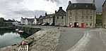 | |||
| Shorehead, Corf Warehouse (Portsoy Marble) | 57°41′06″N 2°41′30″W | Category A | 40293 | | |||
| 2, 4 Shore Street | 57°41′06″N 2°41′23″W | Category C(S) | 40297 | | |||
| 7, 9 South High Street | 57°40′55″N 2°41′32″W | Category C(S) | 40299 | | |||
| 36, 38 South High Street | 57°40′58″N 2°41′29″W | Category C(S) | 40306 | | |||
| St Comb's Road, St Comb's Well | 57°40′55″N 2°41′08″W | Category C(S) | 40310 | | |||
| 2, 4 Bridge Street | 57°41′00″N 2°41′24″W | Category C(S) | 40217 | | |||
| 46, 48 Church Street, Morven | 57°41′00″N 2°41′21″W | Category C(S) | 40228 | | |||
| 5, 7, 9 Culbert Street | 57°41′01″N 2°41′27″W | Category B | 40235 | | |||
| 18, 20, 22 Culbert Street | 57°41′00″N 2°41′25″W | Category B | 40238 | | |||
| 10 North High Street | 57°41′02″N 2°41′28″W | Category B | 40266 | | |||
| 5 Seafield Place And Garden Walls | 57°40′52″N 2°41′19″W | Category C(S) | 40273 | | |||
| Seafield Terrace, Episcopal Church Of St John The Baptist | 57°40′53″N 2°41′35″W | Category B | 40280 | | |||
| 10 Shorehead, Warehouse Sited Immediately To East | 57°41′05″N 2°41′30″W | Category C(S) | 40291 | | |||
| Shorehead, Old Harbour | 57°41′06″N 2°41′28″W | Category A | 40296 | 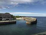 | |||
| 39, 41 South High Street | 57°40′57″N 2°41′31″W | Category C(S) | 40301 | | |||
| 26 The Square | 57°40′58″N 2°41′29″W | Category C(S) | 40315 | | |||
| 1 Wood Street | 57°41′08″N 2°41′15″W | Category C(S) | 40316 | | |||
| 1, 3 Aird Street | 57°40′53″N 2°41′13″W | Category C(S) | 40206 | | |||
| 17 Aird Street | 57°40′52″N 2°41′12″W | Category C(S) | 40212 | | |||
| Church Street, Shore Inn With Boundary Wall | 57°41′04″N 2°41′25″W | Category C(S) | 40234 | | |||
| 15 Hill Street | 57°40′56″N 2°41′37″W | Category C(S) | 40242 | | |||
| 17 Low Street | 57°41′03″N 2°41′26″W | Category C(S) | 40248 | | |||
| 6 Main Street | 57°41′06″N 2°41′16″W | Category C(S) | 40256 | | |||
| Seafield Street, Church Hall And War Memorial | 57°40′54″N 2°41′25″W | Category B | 40275 | | |||
| 26 Seafield Street, Bank Of Scotland | 57°40′53″N 2°41′23″W | Category B | 40279 | | |||
| 2 Seafield Terrace, 'sunnybank' And Garden Walls | 57°40′52″N 2°41′39″W | Category B | 40281 | | |||
| The Square, The Hall | 57°41′00″N 2°41′30″W | Category C(S) | 40311 | | |||
| Aird Street, Roman Catholic Church Of The Annunciation And Enclosing Wall | 57°40′43″N 2°41′20″W | Category B | 40214 | | |||
| 29 Church Street | 57°40′56″N 2°41′19″W | Category C(S) | 40221 | | |||
| 11-21 (Odd Nos) Culbert Street And Courtyard Wall With Arched Entrance | 57°41′01″N 2°41′25″W | Category B | 40236 | | |||
| 36 Cullen Street | 57°40′59″N 2°41′41″W | Category C(S) | 40239 | | |||
| 21, 23 Low Street, 'Malvern', And Garden Walls | 57°41′03″N 2°41′26″W | Category B | 40249 | | |||
| 9 Main Street | 57°41′06″N 2°41′15″W | Category C(S) | 40258 | | |||
| Main Street, Salmon House And Ramp | 57°41′06″N 2°41′14″W | Category B | 40259 | | |||
| 1, 3 North High Street | 57°41′01″N 2°41′30″W | Category B | 40260 | | |||
| Seafield Terrace, Church Of Scotland And Enclosing Walls | 57°40′52″N 2°41′39″W | Category B | 40282 | | |||
| 7 Seafield Terrace, 'Hermiston' With Garden Walls And Gatepiers | 57°40′50″N 2°41′36″W | Category B | 40284 | | |||
| 5 Shorehead | 57°41′04″N 2°41′29″W | Category C(S) | 40288 | | |||
| 43 South High Street | 57°40′58″N 2°41′32″W | Category C(S) | 40302 | | |||
| Soy Park, Scout Hut (Former Railway Station) | 57°40′45″N 2°41′25″W | Category C(S) | 40308 | | |||
| 3 Wood Street, 'Clifton' | 57°41′07″N 2°41′14″W | Category C(S) | 40318 | | |||
| 19, 21 Aird Street | 57°40′52″N 2°41′11″W | Category C(S) | 40213 | | |||
| 54 Aird Street, Presbytery, Rc Church Of The Annunciation And Garden Wall | 57°40′43″N 2°41′19″W | Category B | 40215 | | |||
| 38 Church Street, Millheugh House | 57°40′59″N 2°41′20″W | Category B | 40226 | | |||
| 60 Church Street | 57°41′01″N 2°41′22″W | Category C(S) | 40231 | | |||
| 13, 15 Low Street | 57°41′02″N 2°41′26″W | Category B | 40247 | | |||
| 3 Main Street | 57°41′07″N 2°41′17″W | Category C(S) | 40254 | | |||
| 26 Schoolhendry Street, The Brig | 57°41′03″N 2°41′18″W | Category C(S) | 40271 | | |||
| Shorehead, Portsoy Marble Workshop (Former James Watt's Warehouse) | 57°41′06″N 2°41′30″W | Category B | 40294 | | |||
| 12 South High Street, The Elms, With Garden Walls | 57°40′54″N 2°41′30″W | Category C(S) | 40304 | | |||
| 2 Wood Street | 57°41′07″N 2°41′15″W | Category C(S) | 40317 | | |||
| 9 Aird Street And Steading | 57°40′53″N 2°41′12″W | Category C(S) | 40208 | | |||
| 28, 30, 32 Church Street, Soye House, And Rear Garden Walls | 57°40′58″N 2°41′19″W | Category B | 40223 | | |||
| 40, 42 Church Street | 57°40′59″N 2°41′21″W | Category C(S) | 40227 | | |||
| 14 Culbert Street | 57°41′00″N 2°41′26″W | Category C(S) | 40237 | | |||
| 38 Cullen St, 'Marine Villa' And Rear Garden Wall | 57°40′59″N 2°41′42″W | Category C(S) | 40240 | |
Key
The scheme for classifying buildings in Scotland is:
- Category A: "buildings of national or international importance, either architectural or historic; or fine, little-altered examples of some particular period, style or building type."[1]
- Category B: "buildings of regional or more than local importance; or major examples of some particular period, style or building type, which may have been altered."[1]
- Category C: "buildings of local importance; lesser examples of any period, style, or building type, as originally constructed or moderately altered; and simple traditional buildings which group well with other listed buildings."[1]
In March 2016 there were 47,288 listed buildings in Scotland. Of these, 8% were Category A, and 50% were Category B, with the remaining 42% being Category C.[2]
gollark: Yes.
gollark: I did NOT know you could do what #3 does with identifiers. Unless I wrote that and I actually do.
gollark: I'm glad that the clearly highly intelligent author of #11 recognizes the glory of SQLite3.
gollark: I mean, in practical use you'd just do `sorted`, so they somewhat have to be.
gollark: The palaiologosimulator™ as previously described is not very dynamic, an economy, or hyperrealistic.
Notes
- Sometimes known as OSGB36, the grid reference (where provided) is based on the British national grid reference system used by the Ordnance Survey.
• "Guide to National Grid". Ordnance Survey. Retrieved 2007-12-12.
• "Get-a-map". Ordnance Survey. Retrieved 2007-12-17. - Historic Environment Scotland assign a unique alphanumeric identifier to each designated site in Scotland, for listed buildings this always begins with "LB", for example "LB12345".
References
- All entries, addresses and coordinates are based on data from Historic Scotland. This data falls under the Open Government Licence
- "What is Listing?". Historic Environment Scotland. Retrieved 29 May 2018.
- Scotland's Historic Environment Audit 2016 (PDF). Historic Environment Scotland and the Built Environment Forum Scotland. pp. 15–16. Retrieved 29 May 2018.
This article is issued from Wikipedia. The text is licensed under Creative Commons - Attribution - Sharealike. Additional terms may apply for the media files.