List of listed buildings in Port Glasgow, Inverclyde
List
| Name | Location | Date Listed | Grid Ref. [note 1] | Geo-coordinates | Notes | LB Number [note 2] | Image |
|---|---|---|---|---|---|---|---|
| Former Clune Park Church Of Scotland, Robert Street | 55°55′54″N 4°40′32″W | Category B | 40072 | 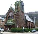 | |||
| School Court, Former Jean Street School, Jean Street And HighHolm Street | 55°56′03″N 4°41′44″W | Category B | 40075 | 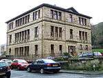 | |||
| 6 And 8 Newark Street | 55°55′56″N 4°40′46″W | Category B | 40077 | 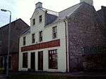 | |||
| Newark Castle, Castle Street | 55°56′04″N 4°40′41″W | Category A | 40069 | 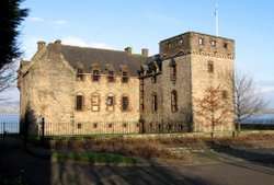 | |||
| Fore Street, Former Municipal Buildings | 55°56′05″N 4°41′15″W | Category A | 40071 | 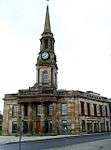 | |||
| Princes Street 49 And 65 Church Street Port Glasgow Royal Bank Building | 55°56′03″N 4°41′26″W | Category B | 40081 | 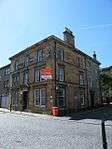 | |||
| Port Glasgow Harbour, Warehouses On West Quay | 55°56′11″N 4°41′20″W | Category C(S) | 40087 | 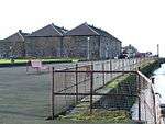 | |||
| Former Newark Parish Church, Glen Avenue. (Halls Excluded) | 55°56′01″N 4°41′37″W | Category B | 40074 | 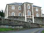 | |||
| St Andrew's Church, Church Street,(West End),(Former Old Parish Church) | 55°56′03″N 4°41′27″W | Category B | 40070 | 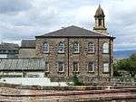 | |||
| Clune Park School, Robert Street | 55°55′53″N 4°40′31″W | Category B | 40073 | 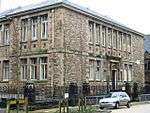 | |||
| King George V1 Club, (Old Peoples' Welfare Council) 9-11 1/2 King Street | 55°56′02″N 4°41′20″W | Category B | 40076 | .jpg) | |||
| Parkhill Farm House, Old Greenock Road | 55°55′38″N 4°38′04″W | Category B | 40079 | 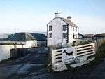 | |||
| Port Glasgow Harbour, West Quay | 55°56′12″N 4°41′20″W | Category B | 40084 | | |||
| Port Glasgow Harbour, Lighthouse Opposite Warehouse On West Quay | 55°56′15″N 4°41′15″W | Category B | 40086 | 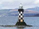 | |||
| Bay Street/Robert Street, Gourock Ropeworks | 55°56′01″N 4°40′55″W | Category A | 40067 | 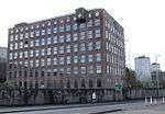 | |||
| Former West Church Of Scotland, Brown St | 55°56′06″N 4°41′45″W | Category B | 40068 | 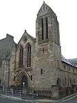 | |||
| 2 Parkhill Avenue, Holy Family Roman Catholic Church And Presbytery | 55°55′43″N 4°39′31″W | Category A | 40088 | 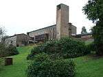 | |||
| Broadfield Hospital, Broadstone House, (Mental Home) Old Greenock Road | 55°55′42″N 4°38′36″W | Ruin | 40078 | 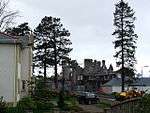 | |||
| Port Glasgow Harbour, Leading Light On West Quay | 55°56′15″N 4°41′26″W | Category B | 40085 | 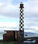 | |||
| Glenpark Drive, Glenpark House | 55°56′03″N 4°42′05″W | Category C(S) | 46409 | 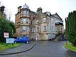 | |||
| Jean Street, Railway Bridge, Bridge Gou/29 | 55°56′05″N 4°41′46″W | Category C(S) | 50127 | 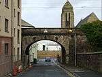 |
Key
The scheme for classifying buildings in Scotland is:
- Category A: "buildings of national or international importance, either architectural or historic; or fine, little-altered examples of some particular period, style or building type."[1]
- Category B: "buildings of regional or more than local importance; or major examples of some particular period, style or building type, which may have been altered."[1]
- Category C: "buildings of local importance; lesser examples of any period, style, or building type, as originally constructed or moderately altered; and simple traditional buildings which group well with other listed buildings."[1]
In March 2016 there were 47,288 listed buildings in Scotland. Of these, 8% were Category A, and 50% were Category B, with the remaining 42% being Category C.[2]
gollark: Well, maybe if you weren't BAD we would not TREASON.
gollark: <@!156021301654454272> INCENTIVE: I can pay you 0.2 banano.
gollark: > in one year gollark and sinth will lose their rolesWhy? This is apiohazardous of you.
gollark: lyric, staff review.
gollark: I'll designate this possibility Project TERRITORIAL RECTIFIER.
Notes
- Sometimes known as OSGB36, the grid reference (where provided) is based on the British national grid reference system used by the Ordnance Survey.
• "Guide to National Grid". Ordnance Survey. Retrieved 2007-12-12.
• "Get-a-map". Ordnance Survey. Retrieved 2007-12-17. - Historic Environment Scotland assign a unique alphanumeric identifier to each designated site in Scotland, for listed buildings this always begins with "LB", for example "LB12345".
References
- All entries, addresses and coordinates are based on data from Historic Scotland. This data falls under the Open Government Licence
- "What is Listing?". Historic Environment Scotland. Retrieved 29 May 2018.
- Scotland's Historic Environment Audit 2016 (PDF). Historic Environment Scotland and the Built Environment Forum Scotland. pp. 15–16. Retrieved 29 May 2018.
This article is issued from Wikipedia. The text is licensed under Creative Commons - Attribution - Sharealike. Additional terms may apply for the media files.