List of listed buildings in Pittenweem, Fife
List
| Name | Location | Date Listed | Grid Ref. [note 1] | Geo-coordinates | Notes | LB Number [note 2] | Image |
|---|---|---|---|---|---|---|---|
| 17, 18 Bruce's Wynd | 56°12′45″N 2°43′48″W | Category C(S) | 40029 |  | |||
| 3 Calman's Wynd The Haven | 56°12′44″N 2°43′53″W | Category C(S) | 40030 | | |||
| 4 West Shore | 56°12′43″N 2°43′57″W | Category C(S) | 40039 | | |||
| 9 West Shore | 56°12′44″N 2°43′59″W | Category B | 40042 | | |||
| Retaining Wall To Houses 1-19 West Shore | 56°12′44″N 2°43′58″W | Category B | 40049 | | |||
| 3 James Street | 56°12′51″N 2°43′53″W | Category C(S) | 40053 | | |||
| 1 And 3 Charles Street | 56°12′50″N 2°43′53″W | Category C(S) | 40055 | | |||
| Seaforth Charles Street | 56°12′50″N 2°43′54″W | Category C(S) | 40057 | | |||
| 10 Charles Street (Northern Section) | 56°12′51″N 2°43′56″W | Category C(S) | 40058 | | |||
| 26 Charles Street | 56°12′54″N 2°43′59″W | Category B | 40062 | | |||
| 3 Cove Wynd, Including Outhouse | 56°12′47″N 2°43′38″W | Category C(S) | 40065 | | |||
| 19, 21 High Street | 56°12′49″N 2°43′47″W | Category B | 39904 | | |||
| 31-39 High Street | 56°12′48″N 2°43′48″W | Category B | 39907 | | |||
| 50 High Street | 56°12′46″N 2°43′52″W | Category B | 39930 | | |||
| Grange Cottage West Wynd | 56°12′45″N 2°43′56″W | Category C(S) | 39938 | | |||
| 38 Abbey Wall Road Anchor House | 56°12′47″N 2°43′33″W | Category B | 39965 | | |||
| 7 Water Wynd | 56°12′47″N 2°43′43″W | Category B | 39984 | | |||
| 27 Mid Shore | 56°12′43″N 2°43′49″W | Category C(S) | 40004 | | |||
| 30 And 31 Mid Shore And 1 And 2 Bruce's Wynd | 56°12′43″N 2°43′51″W | Category B | 40006 | | |||
| Pittenweem Harbour | 56°12′43″N 2°43′39″W | Category B | 40015 | 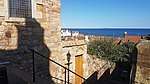 | |||
| Baptist Church, School Wynd | 56°12′45″N 2°43′47″W | Category C(S) | 40017 | | |||
| 10 Bruce's Wynd | 56°12′45″N 2°43′51″W | Category C(S) | 40024 | | |||
| Parish Church Manse Including Offices And Wall To Milton Place, Milton Place | 56°12′55″N 2°43′30″W | Category B | 39874 | | |||
| Roman Catholic Church Enclosing Wall And Entrance Gatepiers | 56°12′55″N 2°43′31″W | Category C(S) | 39876 | | |||
| Milton Lodge (Former Lodge Of Above) Milton Place | 56°12′55″N 2°43′32″W | Category C(S) | 39877 | | |||
| The Hermitage Including Garden Wall, Milton Road | 56°12′57″N 2°43′33″W | Category C(S) | 39881 | | |||
| Corner Bar At Corner Of James Street And Marygate | 56°12′54″N 2°43′35″W | Category C(S) | 39883 | | |||
| Sunnybrae Bruce's Wynd | 56°12′45″N 2°43′49″W | Category C(S) | 40028 | | |||
| 2 West Shore | 56°12′43″N 2°43′56″W | Category C(S) | 40037 | | |||
| 5 West Shore | 56°12′44″N 2°43′57″W | Category C(S) | 40040 | | |||
| 18 Charles Street | 56°12′53″N 2°43′58″W | Category C(S) | 40060 | | |||
| Station Hotel Charles Street, Including Front Wall And Gatepiers | 56°12′56″N 2°44′02″W | Category B | 40063 | | |||
| Grangemuir Bridge Over Dreel Burn | 56°13′15″N 2°44′19″W | Category B | 40064 | | |||
| Kirkgate House Kirkgate | 56°12′50″N 2°43′44″W | Category C(S) | 39897 | | |||
| Kelly Lodge, 23 High Street | 56°12′48″N 2°43′47″W | Category A | 39905 | _Lodge%2C_23_High_Street_(geograph_3466304).jpg) | |||
| 41 High Street | 56°12′47″N 2°43′49″W | Category C(S) | 39908 | | |||
| 43 High Street | 56°12′47″N 2°43′50″W | Category C(S) | 39910 | | |||
| 18 High Street | 56°12′48″N 2°43′46″W | Category C(S) | 39918 | | |||
| 22 High Street | 56°12′48″N 2°43′46″W | Category C(S) | 39920 | | |||
| 2 & 3 Market Place | 56°12′47″N 2°43′47″W | Category B | 39922 | | |||
| 6, 7 & 8 Market Place | 56°12′46″N 2°43′48″W | Category B | 39924 | | |||
| 54 High Street House | 56°12′46″N 2°43′53″W | Category B | 39933 | | |||
| 1 West Wynd | 56°12′45″N 2°43′55″W | Category C(S) | 39937 | | |||
| 1 South Loan | 56°12′48″N 2°43′52″W | Category B | 39939 | | |||
| 10 South Loan | 56°12′48″N 2°43′53″W | Category C(S) | 39944 | | |||
| 16 South Loan | 56°12′48″N 2°43′54″W | Category C(S) | 39947 | | |||
| 22, 24 South Loan | 56°12′49″N 2°43′55″W | Category C(S) | 39949 | | |||
| 30 South Loan | 56°12′50″N 2°43′56″W | Category C(S) | 39952 | | |||
| 7 The Gyles | 56°12′46″N 2°43′34″W | Category B | 39962 | | |||
| 12 East Shore | 56°12′47″N 2°43′39″W | Category C(S) | 39975 | | |||
| 10 Water Wynd | 56°12′47″N 2°43′45″W | Category C(S) | 39987 | | |||
| 3 Mid Shore | 56°12′45″N 2°43′43″W | Category C(S) | 39990 | | |||
| 8-10 Mid Shore | 56°12′44″N 2°43′45″W | Category C(S) | 39994 | | |||
| Rockvilla Mid Shore | 56°12′42″N 2°43′55″W | Category B | 40014 | | |||
| Henderson House, School Wynd Including Garden Wall | 56°12′46″N 2°43′48″W | Category B | 40018 | | |||
| 12 Bruce's Wynd Seaward House | 56°12′45″N 2°43′50″W | Category C(S) | 40026 | | |||
| 4 And 6 Calman's Wynd | 56°12′44″N 2°43′53″W | Category B | 40034 | | |||
| 1 James Street And 5 Charles Street | 56°12′50″N 2°43′53″W | Category B | 40054 | | |||
| 22 Charles Street | 56°12′53″N 2°43′59″W | Category C(S) | 40061 | | |||
| 22 Marygate Carradale | 56°12′54″N 2°43′35″W | Category C(S) | 39891 | | |||
| Edina Cottage Routine Row | 56°12′51″N 2°43′45″W | Category C(S) | 39892 | | |||
| Kirkgate At Corner Of Routine Row (Mr Baird) | 56°12′51″N 2°43′45″W | Category C(S) | 39894 | | |||
| Le Marne, Kirkgate | 56°12′50″N 2°43′45″W | Category C(S) | 39896 | | |||
| 15 High Street | 56°12′49″N 2°43′46″W | Category C(S) | 39902 | | |||
| 17 High Street | 56°12′49″N 2°43′46″W | Category B | 39903 | | |||
| 27 And 29 High Street | 56°12′48″N 2°43′48″W | Category B | 39906 | | |||
| 59 High Street | 56°12′46″N 2°43′53″W | Category C(S) | 39914 | | |||
| 44 High Street | 56°12′46″N 2°43′52″W | Category B | 39928 | | |||
| 52 High Street Showroom And Store | 56°12′46″N 2°43′53″W | Category C(S) | 39931 | | |||
| 60 High Street | 56°12′46″N 2°43′55″W | Category C(S) | 39936 | | |||
| 6 South Loan | 56°12′47″N 2°43′52″W | Category B | 39942 | | |||
| 20 South Loan | 56°12′49″N 2°43′55″W | Category C(S) | 39948 | | |||
| 10 & 11 Cove Wyne, Including Garden Wall To Wynd | 56°12′48″N 2°43′40″W | Category C(S) | 39957 | | |||
| 48 Abbey Wall Road | 56°12′47″N 2°43′35″W | Category C(S) | 39963 | | |||
| 46 Abbey Wall Road | 56°12′47″N 2°43′34″W | Category C(S) | 39964 | | |||
| 18 East Shore | 56°12′46″N 2°43′41″W | Category A | 39978 | | |||
| 5 Water Wynd | 56°12′46″N 2°43′43″W | Category B | 39983 | | |||
| 8 Water Wynd | 56°12′47″N 2°43′43″W | Category B | 39985 | | |||
| 15, 16, 17 Mid Shore | 56°12′44″N 2°43′46″W | Category C(S) | 39997 | | |||
| 22 And 23 Mid Shore | 56°12′43″N 2°43′48″W | Category C(S) | 40001 | | |||
| 28 And 29 Mid Shore | 56°12′43″N 2°43′50″W | Category C(S) | 40005 | | |||
| 36 Mid Shore St Clair | 56°12′43″N 2°43′53″W | Category C(S) | 40010 | | |||
| 38 And 39 Mid Shore | 56°12′43″N 2°43′54″W | Category C(S) | 40012 | | |||
| The Crow's Nest School Wynd | 56°12′45″N 2°43′48″W | Category C(S) | 40019 | | |||
| 4, 5, 6 Bruce's Wynd | 56°12′44″N 2°43′51″W | Category C(S) | 40022 | | |||
| The Priory Including North Courtyard Wall And Retaining Walls To Cove Wynd | 56°12′49″N 2°43′40″W | Category A | 39871 | | |||
| The Priory - Gatehouse | 56°12′50″N 2°43′39″W | Category A | 39872 | 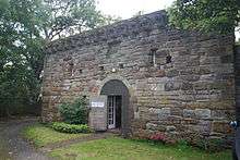 | |||
| 3 Routine Row | 56°12′51″N 2°43′45″W | Category C(S) | 50055 | | |||
| 13 Bruce's Wynd Tigh Na Mara | 56°12′45″N 2°43′49″W | Category C(S) | 40027 | | |||
| House (Mr Legget) Calman's Wynd | 56°12′43″N 2°43′52″W | Category C(S) | 40031 | | |||
| 17 Charles Street And 1-3 Session St | 56°12′53″N 2°43′56″W | Category C(S) | 40056 | | |||
| Clydesdale Bank, 1 High Street And Bank House, Kirkgate | 56°12′50″N 2°43′44″W | Category B | 39898 | | |||
| 49 High Street Royal Bank Of Scotland | 56°12′47″N 2°43′51″W | Category C(S) | 39912 | | |||
| 51 And 53 High Street, Corner Of South Loan | 56°12′47″N 2°43′52″W | Category C(S) | 39913 | | |||
| 61 High Street | 56°12′46″N 2°43′54″W | Category C(S) | 39915 | | |||
| 4-8 High Street | 56°12′49″N 2°43′44″W | Category B | 39917 | | |||
| 20 High Street | 56°12′48″N 2°43′46″W | Category C(S) | 39919 | | |||
| Bankview, At Rear Of Lawson's 34, 36 Market Place | 56°12′46″N 2°43′50″W | Category B | 39925 | | |||
| 42 High Street | 56°12′46″N 2°43′50″W | Category C(S) | 39927 | | |||
| 54 High Street Warehouse | 56°12′46″N 2°43′53″W | Category C(S) | 39932 | | |||
| 58 High Street Including Garden Wall To Calman's Wynd | 56°12′46″N 2°43′55″W | Category B | 39935 | | |||
| 2 Backgate, Corner Of South Loan | 56°12′48″N 2°43′52″W | Category C(S) | 39941 | | |||
| 8 Cove Wynd | 56°12′48″N 2°43′40″W | Category B | 39955 | | |||
| Priorsgate Cove Wynd Including Garden Wall To Wynd | 56°12′49″N 2°43′42″W | Category C(S) | 39958 | | |||
| 9 And 10 Abbey Wall Road | 56°12′46″N 2°43′34″W | Category C(S) | 39966 | | |||
| 20 East Shore | 56°12′46″N 2°43′41″W | Category C(S) | 39979 | | |||
| 22 East Shore | 56°12′46″N 2°43′42″W | Category C(S) | 39980 | | |||
| 5 Mid Shore And 3 School Wynd | 56°12′45″N 2°43′44″W | Category B | 39992 | | |||
| 7 Mid Shore, Larachmhor, And 1 School Wynd | 56°12′45″N 2°43′44″W | Category C(S) | 39993 | | |||
| 11, 12 Mid Shore | 56°12′44″N 2°43′46″W | Category B | 39995 | | |||
| 19 Mid Shore, Heraean | 56°12′43″N 2°43′47″W | Category C(S) | 39999 | | |||
| House (Lawson) School Wynd | 56°12′46″N 2°43′48″W | Category C(S) | 40020 | | |||
| House (Methvyn) School Wynd, Corner Of Market Place | 56°12′46″N 2°43′49″W | Category B | 40021 | | |||
| St Margaret's Milton Place, Corner Of James Street | 56°12′55″N 2°43′34″W | Category C(S) | 39878 | | |||
| St Margaret's Farm Buildings Corner Of Milton Place, Milton Place, Milton Road And James Street | 56°12′55″N 2°43′34″W | Category C(S) | 39879 | | |||
| 1 West Shore Including Garage And Gear Shed | 56°12′43″N 2°43′56″W | Category B | 40036 | | |||
| 14 West Shore | 56°12′44″N 2°44′00″W | Category B | 40045 | | |||
| 15 West Shore | 56°12′44″N 2°44′00″W | Category C(S) | 40046 | | |||
| 16 West Shore | 56°12′44″N 2°44′01″W | Category B | 40047 | | |||
| 17, 18, 19 West Shore | 56°12′44″N 2°44′02″W | Category B | 40048 | | |||
| 27 James Street Including Front Area Wall | 56°12′52″N 2°43′44″W | Category B | 40052 | | |||
| Cosy Cottage, Charles Street | 56°12′52″N 2°43′57″W | Category C(S) | 40059 | | |||
| 19 & 20 Marygate | 56°12′53″N 2°43′36″W | Category C(S) | 39889 | | |||
| 21 Marygate | 56°12′54″N 2°43′36″W | Category C(S) | 39890 | | |||
| House (Mr Mcqueen) Adjoining Le Marne On North Kirkgate | 56°12′50″N 2°43′45″W | Category C(S) | 39895 | | |||
| 2 High Street | 56°12′49″N 2°43′43″W | Category B | 39916 | | |||
| 46 & 48 High Street | 56°12′46″N 2°43′52″W | Category B | 39929 | | |||
| 3, 5 South Loan | 56°12′48″N 2°43′52″W | Category B | 39940 | | |||
| 12 South Loan | 56°12′48″N 2°43′53″W | Category C(S) | 39945 | | |||
| 4 And 5 East Shore | 56°12′47″N 2°43′36″W | Category B | 39970 | | |||
| 10 East Shore And 1 Cove Wynd | 56°12′47″N 2°43′38″W | Category C(S) | 39973 | | |||
| 11 East Shore | 56°12′47″N 2°43′39″W | Category C(S) | 39974 | | |||
| 3 Water Wynd Setonville | 56°12′46″N 2°43′42″W | Category C(S) | 39982 | | |||
| 40 Mid Shore The Thill | 56°12′43″N 2°43′54″W | Category C(S) | 40013 | | |||
| 7, 9 Bruce's Wynd | 56°12′44″N 2°43′51″W | Category C(S) | 40023 | | |||
| Churchyard Walls And Gravestones | 56°12′50″N 2°43′42″W | Category B | 39870 | | |||
| Roman Catholic Church, Milton Place | 56°12′57″N 2°43′30″W | Category C(S) | 39875 | | |||
| 16 & 17 Marygate | 56°12′53″N 2°43′37″W | Category C(S) | 39887 | | |||
| 18 Marygate | 56°12′53″N 2°43′37″W | Category C(S) | 39888 | | |||
| 11 Bruce's Wynd | 56°12′45″N 2°43′50″W | Category B | 40025 | | |||
| 2 Calman's Wynd | 56°12′43″N 2°43′53″W | Category B | 40033 | | |||
| 8 Calman's Wynd | 56°12′44″N 2°43′54″W | Category B | 40035 | | |||
| 6 And 7 West Shore | 56°12′44″N 2°43′57″W | Category B | 40041 | | |||
| 5 High Street | 56°12′49″N 2°43′44″W | Category C(S) | 39899 | | |||
| 11 & 13 High Street | 56°12′49″N 2°43′45″W | Category B | 39901 | | |||
| 26 High Street And 1 Market Place | 56°12′47″N 2°43′47″W | Category B | 39921 | | |||
| 4 & 5 Market Place Including Outbuilding At Rear | 56°12′46″N 2°43′48″W | Category B | 39923 | | |||
| 56 High Street | 56°12′45″N 2°43′54″W | Category C(S) | 39934 | | |||
| 14 South Loan | 56°12′48″N 2°43′53″W | Category C(S) | 39946 | | |||
| 26 South Loan | 56°12′49″N 2°43′55″W | Category C(S) | 39950 | | |||
| 7 Cove Wynd | 56°12′47″N 2°43′39″W | Category C(S) | 39954 | | |||
| Gyles House | 56°12′45″N 2°43′34″W | Category A | 39959 | .jpg) | |||
| Outbuildings Of 1 And 2 East Shore | 56°12′47″N 2°43′35″W | Category C(S) | 39969 | | |||
| House And Garages Within Court At 5 East Shore | 56°12′47″N 2°43′36″W | Category C(S) | 39971 | | |||
| 7 And 8 East Shore | 56°12′47″N 2°43′37″W | Category B | 39972 | | |||
| 23 East Shore And 1 Water Wynd | 56°12′46″N 2°43′42″W | Category C(S) | 39981 | | |||
| 4 Mid Shore | 56°12′45″N 2°43′44″W | Category B | 39991 | | |||
| 18 Mid Shore Kilnamara | 56°12′44″N 2°43′47″W | Category C(S) | 39998 | | |||
| 32, 33 Mid Shore | 56°12′43″N 2°43′52″W | Category C(S) | 40007 | | |||
| The Harbour Granary | 56°12′44″N 2°43′43″W | Category B | 40016 | | |||
| 15 Marygate | 56°12′52″N 2°43′39″W | Category C(S) | 39886 | | |||
| Houses (Miss Wilson) Calman's Wynd | 56°12′45″N 2°43′54″W | Category C(S) | 40032 | | |||
| 3 West Shore Craig Ard | 56°12′43″N 2°43′56″W | Category C(S) | 40038 | | |||
| 11 West Shore | 56°12′44″N 2°43′59″W | Category C(S) | 40043 | | |||
| 12 West Shore | 56°12′44″N 2°44′00″W | Category B | 40044 | | |||
| Murrayfield House James Street | 56°12′54″N 2°43′43″W | Category B | 40050 | | |||
| 40 High Street | 56°12′46″N 2°43′51″W | Category B | 39926 | | |||
| 1 And 2 East Shore | 56°12′47″N 2°43′35″W | Category C(S) | 39968 | | |||
| 13 And 14 East Shore | 56°12′47″N 2°43′39″W | Category C(S) | 39976 | | |||
| 11 Water Wynd Including Garden Wall To Wynd | 56°12′48″N 2°43′44″W | Category B | 39986 | | |||
| 24 And 25 Mid Shore Thistle House | 56°12′43″N 2°43′48″W | Category C(S) | 40002 | | |||
| 26 Mid Shore | 56°12′43″N 2°43′49″W | Category C(S) | 40003 | | |||
| 34, 35 Mid Shore | 56°12′43″N 2°43′52″W | Category B | 40009 | | |||
| 37 Mid Shore | 56°12′43″N 2°43′53″W | Category C(S) | 40011 | | |||
| Pittenweem Parish Church | 56°12′50″N 2°43′43″W | Category A | 39868 | 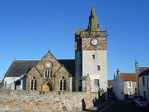 | |||
| Abbey Lodge Corner Marygate, Milton Place And Abbey Wall Road, Including Garden Wall | 56°12′54″N 2°43′33″W | Category C(S) | 39880 | | |||
| 12, 13 Marygate | 56°12′52″N 2°43′40″W | Category C(S) | 39884 | | |||
| 14 Marygate | 56°12′52″N 2°43′40″W | Category C(S) | 39885 | | |||
| Church Of Scotland Hall Including Front Wall And Gatepiers James Street | 56°12′53″N 2°43′46″W | Category B | 40051 | | |||
| 7 & 9 High Street | 56°12′49″N 2°43′45″W | Category C(S) | 39900 | | |||
| House In Brown's Close, Adjoining Old Golf Tavern, And British Legion Building At Rear | 56°12′48″N 2°43′50″W | Category B | 39909 | | |||
| 49 High Street Town Clerk's Office Including Garden Wall To South Loan | 56°12′47″N 2°43′50″W | Category C(S) | 39911 | | |||
| 8 South Loan Including Garden Wall To South Loan | 56°12′47″N 2°43′52″W | Category C(S) | 39943 | | |||
| 28 South Loan | 56°12′49″N 2°43′56″W | Category C(S) | 39951 | | |||
| 32 South Loan | 56°12′50″N 2°43′57″W | Category C(S) | 39953 | | |||
| 9 Cove Wynd | 56°12′48″N 2°43′40″W | Category B | 39956 | | |||
| 3 The Gyles | 56°12′46″N 2°43′35″W | Category B | 39960 | | |||
| 4-6 The Gyles | 56°12′46″N 2°43′34″W | Category A | 39961 | | |||
| Rovers' Warehouse, Abbey Wall Road (Next To No 9 And 10 Abbey Wall Road To North-East) | 56°12′46″N 2°43′33″W | Category B | 39967 | | |||
| 16 East Shore | 56°12′47″N 2°43′40″W | Category C(S) | 39977 | | |||
| 12 Water Wynd | 56°12′48″N 2°43′45″W | Category B | 39988 | | |||
| 1 And 2 Mid Shore And Water Wynd | 56°12′45″N 2°43′43″W | Category C(S) | 39989 | | |||
| 14 Mid Shore | 56°12′44″N 2°43′46″W | Category C(S) | 39996 | | |||
| 21 Mid Shore, Elim And The Forth | 56°12′43″N 2°43′47″W | Category C(S) | 40000 | | |||
| 1 Gascon's Close Mid Shore | 56°12′44″N 2°43′51″W | Category C(S) | 40008 | | |||
| Market Cross, At Tower Of Parish Church | 56°12′50″N 2°43′43″W | Category B | 39869 | | |||
| The Priory - St Fillan's Cave | 56°12′48″N 2°43′39″W | Category B | 39873 | | |||
| St John's Episcopal Church, Marygate | 56°12′51″N 2°43′40″W | Category B | 39882 | | |||
| James Street, Pittenweem Primary School Including Ancillary Structures, Gate Piers And Boundary Walls | 56°12′54″N 2°43′50″W | Category B | 49885 | |
Key
The scheme for classifying buildings in Scotland is:
- Category A: "buildings of national or international importance, either architectural or historic; or fine, little-altered examples of some particular period, style or building type."[1]
- Category B: "buildings of regional or more than local importance; or major examples of some particular period, style or building type, which may have been altered."[1]
- Category C: "buildings of local importance; lesser examples of any period, style, or building type, as originally constructed or moderately altered; and simple traditional buildings which group well with other listed buildings."[1]
In March 2016 there were 47,288 listed buildings in Scotland. Of these, 8% were Category A, and 50% were Category B, with the remaining 42% being Category C.[2]
gollark: Wow! I actually got what I asked for in the Hub!
gollark: I'll just play as usual and end up with a few by September.
gollark: I told you it would affect xenowyrm demand.
gollark: Either that or the drama which sometimes occurs. There have been complaints on the silly DC Confessions thing about it.
gollark: They were annoyed at our reaction to a bug or something.
See also
Notes
- Sometimes known as OSGB36, the grid reference (where provided) is based on the British national grid reference system used by the Ordnance Survey.
• "Guide to National Grid". Ordnance Survey. Retrieved 2007-12-12.
• "Get-a-map". Ordnance Survey. Retrieved 2007-12-17. - Historic Environment Scotland assign a unique alphanumeric identifier to each designated site in Scotland, for listed buildings this always begins with "LB", for example "LB12345".
References
- All entries, addresses and coordinates are based on data from Historic Scotland. This data falls under the Open Government Licence
- "What is Listing?". Historic Environment Scotland. Retrieved 29 May 2018.
- Scotland's Historic Environment Audit 2016 (PDF). Historic Environment Scotland and the Built Environment Forum Scotland. pp. 15–16. Retrieved 29 May 2018.
This article is issued from Wikipedia. The text is licensed under Creative Commons - Attribution - Sharealike. Additional terms may apply for the media files.