List of listed buildings in Pitsligo, Aberdeenshire
List
| Name | Location | Date Listed | Grid Ref. [note 1] | Geo-coordinates | Notes | LB Number [note 2] | Image |
|---|---|---|---|---|---|---|---|
| Pittulie, 38 High Street | 57°41′55″N 2°04′11″W | Category C(S) | 15903 |  | |||
| Pittulie, 44 High Street | 57°41′54″N 2°04′08″W | Category C(S) | 15907 | | |||
| Peathill, Burial Ground | 57°41′09″N 2°06′46″W | Category B | 15913 | | |||
| Pittulie, 59 High Street And Rear Cottage | 57°41′52″N 2°04′05″W | Category C(S) | 15881 | | |||
| Pittulie, 3 High Street | 57°41′54″N 2°04′08″W | Category C(S) | 15886 | | |||
| Pittulie, 12 High Street | 57°41′55″N 2°04′15″W | Category C(S) | 15891 | | |||
| Pittulie, 13 High Street | 57°41′55″N 2°04′15″W | Category C(S) | 15892 | | |||
| Pittulie, 15 High Street | 57°41′56″N 2°04′16″W | Category C(S) | 15893 | | |||
| Peathill, Old Church Of Scotland | 57°41′09″N 2°06′45″W | Category A | 15912 | 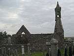 | |||
| Pittendrum, Mains Of Pittendrum House | 57°41′34″N 2°03′41″W | Category A | 15914 | 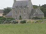 | |||
| Pittulie, 62 High Street | 57°41′52″N 2°04′02″W | Category C(S) | 15884 | | |||
| Pittulie, 25 High Street | 57°41′57″N 2°04′17″W | Category C(S) | 15897 | | |||
| Pittulie, 41 High Street | 57°41′54″N 2°04′09″W | Category C(S) | 15905 | | |||
| Pittulie, 55, 56 High Street | 57°41′52″N 2°04′01″W | Category C(S) | 15878 | | |||
| Pittulie, 60 High Street | 57°41′52″N 2°04′03″W | Category C(S) | 15882 | | |||
| Sandhaven, Main Street, Sandhaven Mill | 57°41′42″N 2°03′28″W | Category B | 15885 | | |||
| Pittulie, 20 High Street | 57°41′57″N 2°04′19″W | Category C(S) | 15894 | | |||
| Pittulie, 27 High Street | 57°41′56″N 2°04′16″W | Category C(S) | 15898 | | |||
| Pittulie, 29 High Street, House And Store | 57°41′56″N 2°04′15″W | Category C(S) | 15899 | | |||
| Pittulie, 40 High Street | 57°41′55″N 2°04′10″W | Category C(S) | 15904 | | |||
| Peathill, Glebe House (Former Church Of Scotland Manse), Walled Garden And Steading | 57°41′06″N 2°06′43″W | Category B | 15910 | | |||
| Pittulie Castle | 57°41′35″N 2°05′37″W | Category A | 15915 | 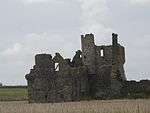 | |||
| Pittulie, 49 High Street | 57°41′54″N 2°04′05″W | Category C(S) | 15873 | | |||
| Pittulie, 61 High Street | 57°41′52″N 2°04′03″W | Category C(S) | 15883 | | |||
| Pittulie, 8 High Street | 57°41′54″N 2°04′13″W | Category C(S) | 15890 | | |||
| Pittulie, 21 High Street | 57°41′56″N 2°04′16″W | Category C(S) | 15895 | | |||
| Braco Park, Dovecot | 57°41′17″N 2°07′52″W | Category C(S) | 15908 | | |||
| Mounthooley Dovecot | 57°41′00″N 2°07′41″W | Category A | 15909 | 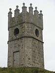 | |||
| Pittulie, 58 High Street | 57°41′53″N 2°04′04″W | Category C(S) | 15880 | | |||
| Pittulie, 6 High Street | 57°41′54″N 2°04′12″W | Category C(S) | 15888 | | |||
| Pittulie, 7 High Street | 57°41′54″N 2°04′12″W | Category C(S) | 15889 | | |||
| Pitsligo Castle | 57°41′32″N 2°06′24″W | Category A | 13884 | 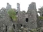 | |||
| Pittulie, 24 High Street | 57°41′57″N 2°04′17″W | Category C(S) | 15896 | | |||
| Pittulie, 35 High Street | 57°41′55″N 2°04′12″W | Category C(S) | 15901 | | |||
| Pittulie, 43 High Street | 57°41′57″N 2°04′17″W | Category C(S) | 15906 | | |||
| Peathill, Hill Kirk (Pitsligo Parish Church Of Scotland) | 57°41′11″N 2°06′42″W | Category A | 15911 | 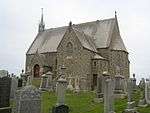 | |||
| Pittulie, 2 High Street | 57°41′54″N 2°04′07″W | Category C(S) | 15917 | | |||
| Pittulie, 50 High Street | 57°41′54″N 2°04′05″W | Category C(S) | 15874 | | |||
| Pittulie, 53 High Street | 57°41′53″N 2°04′04″W | Category C(S) | 15876 | | |||
| Pittulie, 34 High Street | 57°41′55″N 2°04′12″W | Category C(S) | 15900 | | |||
| Pittulie, 1 High Street | 57°41′54″N 2°04′06″W | Category C(S) | 15916 | | |||
| Pittulie, 47 High Street | 57°41′54″N 2°04′06″W | Category C(S) | 15872 | | |||
| Pittulie, 52 High Street | 57°41′54″N 2°04′04″W | Category C(S) | 15875 | | |||
| Pittulie, 54 High Street | 57°41′53″N 2°04′03″W | Category B | 15877 | | |||
| Pittulie, 37 High Street | 57°41′55″N 2°04′11″W | Category C(S) | 15902 | | |||
| Pittulie, 57 High Street | 57°41′52″N 2°04′01″W | Category C(S) | 15879 | | |||
| Pittulie, 5 High Street | 57°41′54″N 2°04′10″W | Category C(S) | 15887 | |
Key
The scheme for classifying buildings in Scotland is:
- Category A: "buildings of national or international importance, either architectural or historic; or fine, little-altered examples of some particular period, style or building type."[1]
- Category B: "buildings of regional or more than local importance; or major examples of some particular period, style or building type, which may have been altered."[1]
- Category C: "buildings of local importance; lesser examples of any period, style, or building type, as originally constructed or moderately altered; and simple traditional buildings which group well with other listed buildings."[1]
In March 2016 there were 47,288 listed buildings in Scotland. Of these, 8% were Category A, and 50% were Category B, with the remaining 42% being Category C.[2]
gollark: On Switchcraft (1.12 computercraft server) people have kind of hacked in flight via the kinetic augment.
gollark: They did, I think.
gollark: Yep!
gollark: There is actually a cubic chunks *mod* for infinite world height, but I didn't install it for compatibility reasons.
gollark: If only MC had cubic chunks...
Notes
- Sometimes known as OSGB36, the grid reference (where provided) is based on the British national grid reference system used by the Ordnance Survey.
• "Guide to National Grid". Ordnance Survey. Retrieved 2007-12-12.
• "Get-a-map". Ordnance Survey. Retrieved 2007-12-17. - Historic Environment Scotland assign a unique alphanumeric identifier to each designated site in Scotland, for listed buildings this always begins with "LB", for example "LB12345".
References
- All entries, addresses and coordinates are based on data from Historic Scotland. This data falls under the Open Government Licence
- "What is Listing?". Historic Environment Scotland. Retrieved 29 May 2018.
- Scotland's Historic Environment Audit 2016 (PDF). Historic Environment Scotland and the Built Environment Forum Scotland. pp. 15–16. Retrieved 29 May 2018.
This article is issued from Wikipedia. The text is licensed under Creative Commons - Attribution - Sharealike. Additional terms may apply for the media files.