List of listed buildings in Panbride, Angus
List
| Name | Location | Date Listed | Grid Ref. [note 1] | Geo-coordinates | Notes | LB Number [note 2] | Image |
|---|---|---|---|---|---|---|---|
| Panmure Estate Margaret's Mount | 56°32′12″N 2°44′37″W | Category B | 18420 |  | |||
| Panmure Estate - The East Gate | 56°32′21″N 2°44′28″W | Category B | 18421 | | |||
| Hatton House - Doocot | 56°31′29″N 2°40′07″W | Category B | 18425 | | |||
| Craigmill Bridge Over Craigmill Burn | 56°30′48″N 2°41′33″W | Category B | 19879 | | |||
| Panbride Parish Kirk | 56°30′44″N 2°41′53″W | Category C(S) | 18434 | 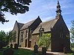 | |||
| Panmure Estate - Gazebo, Corrieara Den (1) | 56°32′01″N 2°45′40″W | Category B | 18414 | | |||
| Panmure Estate - The West Gate | 56°32′08″N 2°45′52″W | Category A | 18418 | | |||
| Panmure Estate - Commemorative Column | 56°32′25″N 2°45′13″W | Category A | 18419 | .jpg) | |||
| Parish School House | 56°30′44″N 2°41′55″W | Category B | 18437 | | |||
| Panmure Castle - Bridge Over Monikie Burn | 56°32′02″N 2°45′26″W | Category B | 18412 | | |||
| Panbride Burial Aisle | 56°30′45″N 2°41′52″W | Category B | 18435 | | |||
| Panmure Estate - Former Stables And Service Court | 56°32′13″N 2°45′11″W | Category B | 49308 | | |||
| Panmure Estate - Artificial Ruins | 56°31′42″N 2°47′19″W | Category B | 19877 | | |||
| Panmure Castle | 56°31′44″N 2°44′31″W | Category B | 18411 | | |||
| Panmure Estate - Montague Bridge Over Monikie Burn | 56°32′07″N 2°45′47″W | Category B | 18416 | | |||
| Panbride House | 56°30′29″N 2°41′10″W | Category B | 18422 | | |||
| Hatton Farmhouse | 56°31′36″N 2°40′08″W | Category B | 18426 | | |||
| Pitlivie Farmhouse | 56°32′08″N 2°43′43″W | Category C(S) | 19148 | | |||
| Panmure Estate - Gardener's House | 56°31′44″N 2°44′45″W | Category B | 18413 | | |||
| Panmure Estate - Gazebo, Corrieara Den (2) | 56°32′03″N 2°45′26″W | Category B | 18415 | | |||
| Panbride House - Stables | 56°30′30″N 2°41′11″W | Category B | 18423 | | |||
| Hatton House | 56°31′26″N 2°40′08″W | Category B | 18424 | | |||
| Loupin'-On-Stane, Parish Kirk, Courtyard | 56°30′46″N 2°41′53″W | Category B | 18436 | |
Key
The scheme for classifying buildings in Scotland is:
- Category A: "buildings of national or international importance, either architectural or historic; or fine, little-altered examples of some particular period, style or building type."[1]
- Category B: "buildings of regional or more than local importance; or major examples of some particular period, style or building type, which may have been altered."[1]
- Category C: "buildings of local importance; lesser examples of any period, style, or building type, as originally constructed or moderately altered; and simple traditional buildings which group well with other listed buildings."[1]
In March 2016 there were 47,288 listed buildings in Scotland. Of these, 8% were Category A, and 50% were Category B, with the remaining 42% being Category C.[2]
gollark: Yes.
gollark: The government here *is* apparently happy to pass stuff like the investigatory powers bill.
gollark: That doesn't seem to be a particularly universal view there, given the popularity of gun control stuff and the fact that as far as I know quite a lot of places still have knife restrictions.
gollark: Doesn't that also describe the US to quite a significant degree?
gollark: <@351074492577218560> Technically you can use external PCIe GPUs with the Pi. It's fiddly and you have to desolder the USB chip.
See also
Notes
- Sometimes known as OSGB36, the grid reference (where provided) is based on the British national grid reference system used by the Ordnance Survey.
• "Guide to National Grid". Ordnance Survey. Retrieved 2007-12-12.
• "Get-a-map". Ordnance Survey. Retrieved 2007-12-17. - Historic Environment Scotland assign a unique alphanumeric identifier to each designated site in Scotland, for listed buildings this always begins with "LB", for example "LB12345".
References
- All entries, addresses and coordinates are based on data from Historic Scotland. This data falls under the Open Government Licence
- "What is Listing?". Historic Environment Scotland. Retrieved 29 May 2018.
- Scotland's Historic Environment Audit 2016 (PDF). Historic Environment Scotland and the Built Environment Forum Scotland. pp. 15–16. Retrieved 29 May 2018.
This article is issued from Wikipedia. The text is licensed under Creative Commons - Attribution - Sharealike. Additional terms may apply for the media files.