List of listed buildings in Oldhamstocks, East Lothian
List
| Name | Location | Date Listed | Grid Ref. [note 1] | Geo-coordinates | Notes | LB Number [note 2] | Image |
|---|---|---|---|---|---|---|---|
| Bilsdean Bridge | 55°56′42″N 2°22′52″W | Category B | 14698 |  | |||
| Oldhamstocks, October Cottage With Retaining Wall | 55°55′39″N 2°24′50″W | Category C(S) | 14708 | | |||
| Oldhamstocks, Market Cross | 55°55′40″N 2°25′09″W | Category B | 14711 | | |||
| Oldhamstocks, The Wight House With Retaining Walls | 55°55′39″N 2°25′06″W | Category B | 14713 | | |||
| Dunglass, New Bridge | 55°56′29″N 2°22′12″W | Category B | 14726 | | |||
| Dunglass, Walled Garden And Service Buildings And Hot-Houses | 55°56′28″N 2°22′55″W | Category B | 14732 | | |||
| Oldhamstocks, Bridge | 55°55′33″N 2°24′25″W | Category B | 14734 | | |||
| Oldhamstocks,Mill Cottage | 55°55′35″N 2°24′58″W | Category C(S) | 18958 | | |||
| Dunglass Collegiate Church | 55°56′22″N 2°22′31″W | Category A | 14700 | 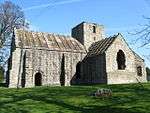 | |||
| Dunglass, Gardener's House With Retaining Walls And Gatepiers | 55°56′31″N 2°22′50″W | Category C(S) | 14704 | | |||
| Oldhamstocks, The Old Manse With Walled Garden And Boundary Walls | 55°55′40″N 2°25′11″W | Category B | 14709 | | |||
| Oldhamstocks Parish Church (Church Of Scotland) With Graveyard Walls And Watch House | 55°55′42″N 2°25′16″W | Category A | 14710 | 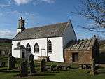 | |||
| Oldhamstocks, Wellhead | 55°55′40″N 2°25′05″W | Category B | 14712 | | |||
| Dunglass, Gazebo | 55°56′17″N 2°22′48″W | Category A | 14725 | | |||
| Dunglass, Old Bridge | 55°56′36″N 2°21′59″W | Category B | 14727 | | |||
| Dunglass, Old Gardener's House | 55°56′30″N 2°22′59″W | Category C(S) | 14728 | | |||
| Dunglass, Farm Lodge | 55°56′41″N 2°22′49″W | Category C(S) | 14703 | | |||
| Dunglass, Gatepiers At West Lodge | 55°56′45″N 2°22′53″W | Category C(S) | 14724 | | |||
| Dunglass, Stables | 55°56′23″N 2°22′35″W | Category B | 14729 | 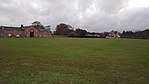 | |||
| Dunglass, Viaduct | 55°56′31″N 2°22′07″W | Category A | 14731 | | |||
| Oldhamstocks, Greenend Cottage | 55°55′42″N 2°25′10″W | Category C(S) | 14735 | | |||
| Dunglass A1 Bridge | 55°56′32″N 2°22′05″W | Category B | 14699 | | |||
| Dunglass, Farm Dairy | 55°56′33″N 2°22′49″W | Category B | 14702 | | |||
| Stottencleugh Farmhouse | 55°55′35″N 2°26′08″W | Category B | 14714 | | |||
| Dunglass, Sundial | 55°56′23″N 2°22′28″W | Category B | 14730 | | |||
| Oldhamstocks, Braeview With Retaining Walls | 55°55′40″N 2°25′04″W | Category B | 14733 | | |||
| Dunglass East Lodge With Gatepiers And Quadrant Wall | 55°56′29″N 2°22′14″W | Category C(S) | 14701 | | |||
| Oldhamstocks, Hillcrest With Retaining Walls | 55°55′39″N 2°25′08″W | Category C(S) | 14736 | |
Key
The scheme for classifying buildings in Scotland is:
- Category A: "buildings of national or international importance, either architectural or historic; or fine, little-altered examples of some particular period, style or building type."[1]
- Category B: "buildings of regional or more than local importance; or major examples of some particular period, style or building type, which may have been altered."[1]
- Category C: "buildings of local importance; lesser examples of any period, style, or building type, as originally constructed or moderately altered; and simple traditional buildings which group well with other listed buildings."[1]
In March 2016 there were 47,288 listed buildings in Scotland. Of these, 8% were Category A, and 50% were Category B, with the remaining 42% being Category C.[2]
gollark: Some of them are kind of blurry because digital zoom.
gollark: I do have about 5 more pictures of the goose, actually.
gollark: This is in Bristol. I was briefly there ironically.
gollark: Here's a picture of a goose, if it helps at all.
gollark: Visibility levels?
Notes
- Sometimes known as OSGB36, the grid reference (where provided) is based on the British national grid reference system used by the Ordnance Survey.
• "Guide to National Grid". Ordnance Survey. Retrieved 2007-12-12.
• "Get-a-map". Ordnance Survey. Retrieved 2007-12-17. - Historic Environment Scotland assign a unique alphanumeric identifier to each designated site in Scotland, for listed buildings this always begins with "LB", for example "LB12345".
References
- All entries, addresses and coordinates are based on data from Historic Scotland. This data falls under the Open Government Licence
- "What is Listing?". Historic Environment Scotland. Retrieved 29 May 2018.
- Scotland's Historic Environment Audit 2016 (PDF). Historic Environment Scotland and the Built Environment Forum Scotland. pp. 15–16. Retrieved 29 May 2018.
This article is issued from Wikipedia. The text is licensed under Creative Commons - Attribution - Sharealike. Additional terms may apply for the media files.