List of listed buildings in Old Machar, Aberdeen
List
| Name | Location | Date Listed | Grid Ref. [note 1] | Geo-coordinates | Notes | LB Number [note 2] | Image |
|---|---|---|---|---|---|---|---|
| Ellon Road, Gordon Barracks Medical Reception Centre | 57°10′51″N 2°05′13″W | Category B | 18848 |  | |||
| Ellon Road, Gordon Barracks, Corunna Road, Married Quarters Type Iv | 57°10′52″N 2°05′00″W | Category B | 18850 | | |||
| Ellon Road, Gordon Barracks Parade Ground, Other Ranks' Mess | 57°10′50″N 2°05′22″W | Category B | 18852 | | |||
| 2-20 (Inclusive Nos) Cottown Of Balgownie, Bridge Of Don | 57°10′37″N 2°05′42″W | Category B | 15668 | 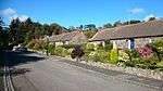 | |||
| Ellon Road Mill Of Mundurno | 57°12′13″N 2°05′20″W | Category B | 15678 | | |||
| Ellon Road, Gordon Barracks Parade Ground Barracks Block A | 57°10′50″N 2°05′24″W | Category B | 18856 | | |||
| Ellon Road, Gordon Barracks Parade Ground Barracks Block B | 57°10′50″N 2°05′19″W | Category B | 18857 | | |||
| Grandholm Works, Old Spinning Mill, Wing Mill, Engine And Turbine Houses | 57°10′38″N 2°07′28″W | Category A | 18985 | 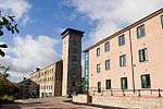 | |||
| Grandhome House | 57°11′47″N 2°10′11″W | Category B | 15673 | | |||
| Lodges And Gate, Grandhome Policies | 57°11′52″N 2°09′38″W | Category B | 15674 | | |||
| Ellon Road, Gordon Barracks, Gymnasium | 57°10′51″N 2°05′22″W | Category B | 18861 | | |||
| Balgownie Lodge Gatehouse | 57°10′43″N 2°06′27″W | Category C(S) | 15672 | | |||
| 79 Balgownie Road, Glover House (Formerly Known As Braehead), Including Boundary Walls | 57°10′43″N 2°06′14″W | Category B | 49996 | .jpg) | |||
| Persleyden, View Cottage | 57°10′44″N 2°07′46″W | Category C(S) | 19110 | | |||
| Ellon Road, Gordon Barracks Parade Ground, Depot Office | 57°10′47″N 2°05′17″W | Category B | 18855 | | |||
| Berryhill Salmon Netting Station | 57°11′56″N 2°04′17″W | Category B | 49960 | | |||
| Danestone House, Walled Garden And Summerhouse | 57°10′50″N 2°07′39″W | Category B | 19109 | | |||
| Ellon Road, Gordon Barracks, Corunna Road, Married Quarters Type Iii | 57°10′52″N 2°05′02″W | Category B | 18849 | | |||
| Ellon Road, Gordon Barracks Parade Ground, Company Office | 57°10′49″N 2°05′18″W | Category B | 18853 | | |||
| Ellon Road,Gordon Barracks Parade Ground Barracks Block D | 57°10′51″N 2°05′20″W | Category B | 18859 | | |||
| Ellon Road, Gordon Barracks Parade Ground, Junior Ranks Club | 57°10′48″N 2°05′17″W | Category B | 18860 | | |||
| Walled Garden And Sundial, Grandhome Policies | 57°11′55″N 2°10′09″W | Category C(S) | 15676 | | |||
| Ellon Road, Gordon Barracks, Corunna Road, Officers Mess | 57°10′52″N 2°05′05″W | Category B | 18851 | | |||
| Danestone House | 57°10′45″N 2°07′41″W | Category B | 19108 | | |||
| Danestone House, Icehouse To South-West Of View Cottage, Persleyden | 57°10′43″N 2°07′48″W | Category B | 19111 | | |||
| Ellon Road, Gordon Barracks Parade Ground Guard Room, Gate Piers And Gates | 57°10′46″N 2°05′23″W | Category B | 18854 | | |||
| Ellon Road, Gordon Barracks Parade Ground Barracks Block C | 57°10′51″N 2°05′24″W | Category B | 18858 | | |||
| "Bridgefield" Balgownie Road Bridge Of Don | 57°10′42″N 2°05′50″W | Category C(S) | 15670 | | |||
| Balgownie Lodge | 57°10′41″N 2°06′38″W | Category B | 15671 | | |||
| Grandhome Dovecot Grandhome Policies | 57°11′49″N 2°09′58″W | Category B | 15675 | | |||
| Bridge Of Don | 57°10′32″N 2°05′26″W | Category B | 15710 | |
Key
The scheme for classifying buildings in Scotland is:
- Category A: "buildings of national or international importance, either architectural or historic; or fine, little-altered examples of some particular period, style or building type."[1]
- Category B: "buildings of regional or more than local importance; or major examples of some particular period, style or building type, which may have been altered."[1]
- Category C: "buildings of local importance; lesser examples of any period, style, or building type, as originally constructed or moderately altered; and simple traditional buildings which group well with other listed buildings."[1]
In March 2016 there were 47,288 listed buildings in Scotland. Of these, 8% were Category A, and 50% were Category B, with the remaining 42% being Category C.[2]
gollark: > <@!258639553357676545> wdym<@543131534685765673> There are not many phones with battery capacities over about 4000mAh.
gollark: uwu bad.
gollark: It's weird how few phones actually have usefully capacious batteries.
gollark: Also, I've almost maybe chosen a phone!
gollark: I can't remember them.
See also
Notes
- Sometimes known as OSGB36, the grid reference (where provided) is based on the British national grid reference system used by the Ordnance Survey.
• "Guide to National Grid". Ordnance Survey. Retrieved 12 December 2007.
• "Get-a-map". Ordnance Survey. Retrieved 17 December 2007. - Historic Environment Scotland assign a unique alphanumeric identifier to each designated site in Scotland, for listed buildings this always begins with "LB", for example "LB12345".
References
- All entries, addresses and coordinates are based on data from Historic Scotland. This data falls under the Open Government Licence
- "What is Listing?". Historic Environment Scotland. Retrieved 29 May 2018.
- Scotland's Historic Environment Audit 2016 (PDF). Historic Environment Scotland and the Built Environment Forum Scotland. pp. 15–16. Retrieved 29 May 2018.
This article is issued from Wikipedia. The text is licensed under Creative Commons - Attribution - Sharealike. Additional terms may apply for the media files.