List of listed buildings in Ochiltree, East Ayrshire
List
| Name | Location | Date Listed | Grid Ref. [note 1] | Geo-coordinates | Notes | LB Number [note 2] | Image |
|---|---|---|---|---|---|---|---|
| Burnock Holm House | 55°27′38″N 4°21′36″W | Category B | 19687 |  | |||
| Nos. 78 And 80 Main Street | 55°27′38″N 4°21′59″W | Category B | 14317 | | |||
| Nos. 86-98 (Even Nos.) Main Street | 55°27′37″N 4°22′00″W | Category B | 14318 | | |||
| Nos 1-13 (Odd Numbers) Mill Street | 55°27′43″N 4°21′40″W | Category B | 14320 | | |||
| Netherton | 55°27′26″N 4°21′56″W | Category B | 14325 | | |||
| Drongan House | 55°26′44″N 4°27′08″W | Category B | 14328 | | |||
| Head Inn , 5 Main Street | 55°27′42″N 4°21′40″W | Category B | 14335 | | |||
| Nos. 69, 71 And 73 Main Street | 55°27′36″N 4°21′59″W | Category B | 14339 | | |||
| No 34 Main Street | 55°27′42″N 4°21′47″W | Category C(S) | 14340 | | |||
| Nos. 77-89 (Odd Numbers) No 89 Known As Orchard Park) Main St | 55°27′35″N 4°22′03″W | Category B | 19688 | | |||
| Ochiltree Mill | 55°27′53″N 4°21′42″W | Category C(S) | 14323 | | |||
| 1,3 And 5 Burnock Street | 55°27′42″N 4°21′38″W | Category B | 14334 | 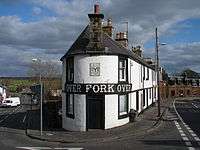 | |||
| Burnock Bridge | 55°27′39″N 4°21′35″W | Category B | 14336 | | |||
| 53 Main Street Ochiltree | 55°27′38″N 4°21′54″W | Category C(S) | 14342 | | |||
| 63 Main Street Ochiltree | 55°27′37″N 4°21′57″W | Category C(S) | 14343 | | |||
| Parish Church | 55°27′40″N 4°21′53″W | Category B | 14316 | | |||
| Nos. 112 And 114 Main Street | 55°27′35″N 4°22′06″W | Category C(S) | 14319 | | |||
| Ochiltree Mains | 55°27′30″N 4°21′28″W | Category C(S) | 14327 | | |||
| Ochiltree Primary School Main Street, Ochiltree | 55°27′37″N 4°21′58″W | Category C(S) | 14344 | | |||
| Nos. 64, 66, And 68 Main Street | 55°27′39″N 4°21′56″W | Category C(S) | 14347 | | |||
| Nos. 56 And 58 Main Street | 55°27′41″N 4°21′50″W | Category C(S) | 18210 | | |||
| No 5 Ayr Road | 55°27′40″N 4°21′45″W | Category C(S) | 14332 | | |||
| Findlayston | 55°27′18″N 4°22′15″W | Category C(S) | 14326 | | |||
| Cemetery | 55°27′46″N 4°21′27″W | Category B | 14330 | | |||
| Market Cross | 55°27′42″N 4°21′40″W | Category B | 14331 | | |||
| Nos 37 And 39 Main Street | 55°27′40″N 4°21′51″W | Category C(S) | 14338 | | |||
| Nos 44 And 46 Main Street | 55°27′42″N 4°21′49″W | Category C(S) | 14341 | | |||
| No 60 (Glencairn) Main Street | 55°27′40″N 4°21′52″W | Category B | 14346 | | |||
| High Barbeth | 55°26′40″N 4°27′42″W | Category C(S) | 14348 | | |||
| Manse | 55°27′46″N 4°21′45″W | Category B | 14329 | | |||
| Blackbush Cottage (Off Ayre Road) | 55°27′36″N 4°21′50″W | Category C(S) | 14333 | | |||
| Lugar Bridge | 55°27′50″N 4°21′22″W | Category B | 14322 | | |||
| House Opposite Manse Gates, Manse Road. (J. Faulds) | 55°27′44″N 4°21′45″W | Category C(S) | 14321 | | |||
| 2/4 Manse Road, Ochiltree | 55°27′43″N 4°21′41″W | Category C(S) | 14324 | | |||
| Old Burnock Bridge | 55°27′39″N 4°21′36″W | Category C(S) | 14337 | | |||
| No 48 Main Street | 55°27′42″N 4°21′49″W | Category C(S) | 14345 | |
Key
The scheme for classifying buildings in Scotland is:
- Category A: "buildings of national or international importance, either architectural or historic; or fine, little-altered examples of some particular period, style or building type."[1]
- Category B: "buildings of regional or more than local importance; or major examples of some particular period, style or building type, which may have been altered."[1]
- Category C: "buildings of local importance; lesser examples of any period, style, or building type, as originally constructed or moderately altered; and simple traditional buildings which group well with other listed buildings."[1]
In March 2016 there were 47,288 listed buildings in Scotland. Of these, 8% were Category A, and 50% were Category B, with the remaining 42% being Category C.[2]
gollark: Though your CPU is worse than that, I guess.
gollark: I ran a server with maybe 50 mods off a Xeon E3-1240 and 4GB of RAM a while ago, and that mostly worked.
gollark: Also, I'd recommend the Foamfix mod, which reduces RAM use a bit.
gollark: Minecraft tends to eat RAM. How much RAM?
gollark: That's doable on some server platforms/
Notes
- Sometimes known as OSGB36, the grid reference (where provided) is based on the British national grid reference system used by the Ordnance Survey.
• "Guide to National Grid". Ordnance Survey. Retrieved 2007-12-12.
• "Get-a-map". Ordnance Survey. Retrieved 2007-12-17. - Historic Environment Scotland assign a unique alphanumeric identifier to each designated site in Scotland, for listed buildings this always begins with "LB", for example "LB12345".
References
- All entries, addresses and coordinates are based on data from Historic Scotland. This data falls under the Open Government Licence
- "What is Listing?". Historic Environment Scotland. Retrieved 29 May 2018.
- Scotland's Historic Environment Audit 2016 (PDF). Historic Environment Scotland and the Built Environment Forum Scotland. pp. 15–16. Retrieved 29 May 2018.
This article is issued from Wikipedia. The text is licensed under Creative Commons - Attribution - Sharealike. Additional terms may apply for the media files.