List of listed buildings in North Berwick, East Lothian
List
| Name | Location | Date Listed | Grid Ref. [note 1] | Geo-coordinates | Notes | LB Number [note 2] | Image |
|---|---|---|---|---|---|---|---|
| Abbots Croft With Gates And Lodge | 56°03′19″N 2°42′08″W | Category C(S) | 38705 |  | |||
| 2 East Road (The Lodge) And 4 East Road (The Wall Tower), Dovecot And Boundary Walls | 56°03′27″N 2°43′02″W | Category B | 38717 | | |||
| Grange Road, The Grange Studio And Lych-Gate | 56°03′12″N 2°43′27″W | Category B | 38725 | | |||
| 53-57 (Odd Nos) High Street | 56°03′30″N 2°43′10″W | Category B | 38736 | | |||
| 4-6 (Even Nos) High Street | 56°03′31″N 2°43′03″W | Category C(S) | 38742 | | |||
| 30 Marmion Road | 56°03′25″N 2°43′31″W | Category B | 38757 | | |||
| 3 Melbourne Road, (Sands Cottage) With Boundary Wall | 56°03′36″N 2°43′01″W | Category C(S) | 38759 | | |||
| 1-9 (Inclusive Nos) The Quadrant With Parapet Walls | 56°03′29″N 2°42′48″W | Category C(S) | 38764 | | |||
| Redside Farm Cottages | 56°01′50″N 2°41′01″W | Category B | 14750 | | |||
| Sheriff Hall Farm Cottages | 56°01′38″N 2°42′07″W | Category B | 14754 | | |||
| Balgone House, South Pavilion, (Originally Mirrored Pair To North Pavilion) | 56°01′55″N 2°41′50″W | Category C(S) | 14718 | | |||
| Sheriff Hall Steading With Horsemill And Stalk | 56°01′38″N 2°42′11″W | Category B | 14719 | | |||
| Sheriff Hall Westgate | 56°01′33″N 2°42′28″W | Category B | 14720 | | |||
| Tantallon Castle | 56°03′23″N 2°39′02″W | Category A | 14722 | .JPG) | |||
| Heugh Farm Dovecot | 56°02′55″N 2°42′14″W | Category B | 14744 | | |||
| Heugh Farm, North Berwick Drinking Water Tank | 56°02′59″N 2°42′07″W | Category B | 14745 | | |||
| 14 Westgate, Blenheim House Hotel With Boundary Walls | 56°03′30″N 2°43′26″W | Category B | 38789 | | |||
| Windygates Road Oldfields, 2 Glenorchy Road | 56°03′17″N 2°43′46″W | Category B | 38791 | | |||
| Windygates Road, Windygates, With Glass House, Walled Garden, Quadrants | 56°03′16″N 2°43′46″W | Category B | 38792 | | |||
| Windygates Road, Marly Knowe With Walls And Terrace | 56°03′11″N 2°43′48″W | Category B | 38793 | | |||
| 12 York Road, St Ann`S With Garden Walls And Statuary | 56°03′35″N 2°43′59″W | Category C(S) | 38796 | | |||
| 28 Dirleton Avenue, Glenconner With Boundary Walls And Gatepiers | 56°03′29″N 2°44′17″W | Category B | 38714 | | |||
| 59-71 And 75-81 (Odd Nos) High Street | 56°03′29″N 2°43′13″W | Category C(S) | 38737 | | |||
| Law Road, Roman Catholic Presbytery | 56°03′20″N 2°43′09″W | Category C(S) | 38751 | | |||
| 3, 5 And 7 Melbourne Place | 56°03′34″N 2°43′01″W | Category C(S) | 38758 | | |||
| 14 And 15 Melbourne Road (Formerly Known As Coastguard Cottages) With Lifeboat House | 56°03′32″N 2°42′53″W | Category C(S) | 38760 | | |||
| Nungate Road, Abbey Farm, Dovecot | 56°03′19″N 2°43′35″W | Category B | 38761 | | |||
| 7-14 (Inclusive Nos) Rhodes Farm Cottages With Boundary Walls | 56°03′25″N 2°41′38″W | Category B | 38769 | | |||
| School Road, Museum And Library | 56°03′31″N 2°42′53″W | Category C(S) | 38772 | | |||
| 5 And 7 Victoria Road | 56°03′35″N 2°43′04″W | Category C(S) | 38775 | | |||
| 31-33 (Odd Nos) Westgate | 56°03′29″N 2°43′32″W | Category B | 38784 | | |||
| Leuchie Stables | 56°02′27″N 2°41′10″W | Category C(S) | 14749 | | |||
| Bonnington Farmhouse | 56°02′36″N 2°42′30″W | Category B | 14740 | | |||
| 45-49 (Odd Nos) Westgate | 56°03′28″N 2°43′35″W | Category B | 38786 | | |||
| 10-12 (Even Nos) Westgate With Retaining Walls | 56°03′30″N 2°43′25″W | Category B | 38788 | | |||
| 38 Dirleton Avenue, Ormesdene And Summer House And Boundary Wall | 56°03′25″N 2°44′30″W | Category B | 38716 | | |||
| 27 East Road And 1 Balfour Street | 56°03′29″N 2°42′52″W | Category B | 38719 | | |||
| 18 Fidra Road, Hyndford, Terrace And Boundary Walls | 56°03′31″N 2°44′15″W | Category B | 38721 | | |||
| 23-25 (Odd Nos) High Street | 56°03′31″N 2°43′11″W | Category C(S) | 38733 | | |||
| 45-47 (Odd Nos) High Street | 56°03′30″N 2°43′08″W | Category B | 38734 | | |||
| St Andrews Street And High Street, St Andrew Blackadder Parish Church And Hall (Church Of Scotland) | 56°03′29″N 2°43′14″W | Category C(S) | 38738 | | |||
| 84-86 (Even Nos) High Street | 56°03′31″N 2°43′14″W | Category C(S) | 38748 | | |||
| 2, 4 And 4A Victoria Road With 1 Melbourne Place | 56°03′34″N 2°43′02″W | Category C(S) | 38774 | | |||
| Redside Farmhouse | 56°01′58″N 2°41′00″W | Category B | 14751 | | |||
| Balgone, North Lodge With Entrance Arch | 56°02′09″N 2°41′25″W | Category B | 14737 | | |||
| Blackdykes Steading With Cartshed And Horsemill | 56°02′40″N 2°40′26″W | Category B | 14739 | | |||
| Bonnington Steading | 56°02′36″N 2°42′30″W | Category B | 14741 | | |||
| 35-37 (Odd Nos) Westgate With Retaining Wall | 56°03′28″N 2°43′32″W | Category C(S) | 38785 | | |||
| Clifford Road, King's Knoll | 56°03′22″N 2°43′25″W | Category B | 38706 | | |||
| 22 Dirleton Avenue, Baltrenon With Boundary Walls | 56°03′29″N 2°44′10″W | Category C(S) | 38712 | | |||
| Grange Road, The Grange, Garden Walls And Gateway | 56°03′13″N 2°43′28″W | Category A | 38723 | | |||
| Grange Road, Power House Cottage | 56°03′10″N 2°43′29″W | Category B | 38727 | | |||
| Harbour | 56°03′40″N 2°43′07″W | Category B | 38730 | 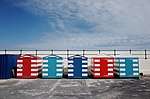 | |||
| 49-51 (Odd Nos) High Street | 56°03′30″N 2°43′09″W | Category C(S) | 38735 | | |||
| 107 High Street | 56°03′28″N 2°43′19″W | Category C(S) | 38740 | | |||
| 8-12 (Even Nos) High Street | 56°03′32″N 2°43′03″W | Category C(S) | 38743 | | |||
| 50-54 (Even Nos) High Street | 56°03′31″N 2°43′09″W | Category B | 38745 | | |||
| Law Road, Old Parish Church, Graveyard Walls And Monuments | 56°03′28″N 2°43′07″W | Category B | 38749 | 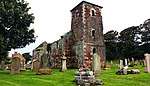 | |||
| 4 Law Road, Glebe House With Gatepiers And Quadrants | 56°03′26″N 2°43′14″W | Category B | 38753 | | |||
| 2-4 (Inc Nos) Nungate Road, (Known As The Nungate) With Boundary Wall And Gateway | 56°03′22″N 2°43′41″W | Category B | 38762 | | |||
| Quality Street, War Memorial | 56°03′30″N 2°43′01″W | Category B | 38766 | | |||
| Rhodes Farmhouse With Gatepiers And Boundary Walls | 56°03′21″N 2°41′46″W | Category B | 38770 | | |||
| 29 Westgate, Well Cottage | 56°03′29″N 2°43′31″W | Category B | 38783 | | |||
| Sydserf House | 56°01′34″N 2°44′15″W | Category A | 14721 | | |||
| Fenton Tower | 56°01′46″N 2°44′04″W | Category A | 14743 | 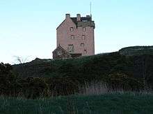 | |||
| Leuchie House, Richard Cave Multiple Sclerosis Holiday Home And La Sagesse Convent | 56°02′26″N 2°41′18″W | Category A | 14746 | 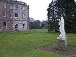 | |||
| 16 Westgate, Normanhurst | 56°03′30″N 2°43′28″W | Category C(S) | 38790 | | |||
| Windygates Road, Coach House, Marly Knowe | 56°03′12″N 2°43′46″W | Category C(S) | 38794 | | |||
| 7 And 9 Dirleton Avenue | 56°03′29″N 2°43′52″W | Category C(S) | 38708 | | |||
| 23, 25 East Road | 56°03′29″N 2°42′52″W | Category C(S) | 38718 | | |||
| 15 Glenorchy Road. Glenorchy, With Boundary Walls And Gateways | 56°03′16″N 2°43′49″W | Category B | 38722 | | |||
| 125-127 (Odd Nos) High Street | 56°03′28″N 2°43′21″W | Category C(S) | 38741 | | |||
| 66 High Street, Victoria House | 56°03′31″N 2°43′11″W | Category B | 38747 | | |||
| 11 And 11A Marmion Road | 56°03′25″N 2°43′23″W | Category C(S) | 38754 | | |||
| 2 Quality Street, (The Beehive) | 56°03′30″N 2°43′00″W | Category B | 38767 | | |||
| 10-12 (Even Nos) Quality Street, Dalrymple Arms Hotel | 56°03′32″N 2°43′01″W | Category C(S) | 38768 | | |||
| 27 Westgate | 56°03′29″N 2°43′31″W | Category C(S) | 38782 | | |||
| Redside Steading With Cartshed And Former Engine House | 56°01′58″N 2°40′54″W | Category B | 14752 | | |||
| Sheriff Hall Farmhouse | 56°01′37″N 2°42′08″W | Category B | 14755 | | |||
| 12 York Road, Minaki | 56°03′35″N 2°43′55″W | Category B | 50212 | | |||
| 4 Westgate, Post Office With Gateway | 56°03′30″N 2°43′22″W | Category B | 38787 | | |||
| Dirleton Avenue, St Baldred's Episcopal Church With Retaining Wall And Gatepiers | 56°03′30″N 2°43′51″W | Category B | 38711 | | |||
| 36 Dirleton Avenue, Thurston Lodge | 56°03′26″N 2°44′24″W | Category B | 38715 | | |||
| Grange Road, The Grange Summer House | 56°03′11″N 2°43′31″W | Category B | 38726 | | |||
| 3 Greenheads Road, The Coach House, Lower Coach House And The Loft (Former Known As The Cottage) And Boundary Wall | 56°03′21″N 2°42′33″W | Category C(S) | 38729 | | |||
| 15-17 (Odd Nos) High Street, County Hotel | 56°03′31″N 2°43′04″W | Category C(S) | 38732 | | |||
| 14 And 16 High Street | 56°03′31″N 2°43′04″W | Category C(S) | 38744 | | |||
| 31 Marmion Road And 26 Clifford Road | 56°03′23″N 2°43′32″W | Category B | 38755 | | |||
| 15-17 (Odd Nos) Quality Street | 56°03′31″N 2°43′03″W | Category B | 38765 | | |||
| Victoria Road, East Lothian Yacht Club | 56°03′40″N 2°43′05″W | Category B | 38779 | | |||
| 20 West Bay Road, Point Garry Hotel With Retaining Wall | 56°03′34″N 2°43′46″W | Category C(S) | 38781 | | |||
| Rockville Farm Dovecot | 56°01′38″N 2°43′16″W | Category B | 14753 | | |||
| Balgone House | 56°01′56″N 2°41′48″W | Category A | 14716 | | |||
| Tantallon Castle Dovecot | 56°03′22″N 2°39′05″W | Category A | 14723 | | |||
| Bass Rock, Lighthouse | 56°04′36″N 2°38′28″W | Category C(S) | 14738 | 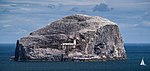 | |||
| Castleton Farmhouse | 56°03′21″N 2°39′29″W | Category B | 14742 | | |||
| Leuchie Gate Lodge, With Entrance Gates | 56°02′24″N 2°41′37″W | Category C(S) | 14747 | | |||
| 24 Dirleton Avenue, The White House With Garden And Boundary Walls | 56°03′28″N 2°44′13″W | Category B | 38713 | | |||
| 33 Fidra Road | 56°03′25″N 2°44′27″W | Category C(S) | 38720 | | |||
| Grange Road, The Grange Lodge, Stables And Walls | 56°03′11″N 2°43′25″W | Category B | 38724 | | |||
| 56-60 (Even Nos) High Street | 56°03′31″N 2°43′09″W | Category C(S) | 38746 | | |||
| 54 St Baldreds Road, Edington Cottage Hospital | 56°03′20″N 2°43′06″W | Category B | 38771 | | |||
| Victoria Road, Blackadder Church With Retaining Walls And Gatepiers (Church Of Scotland | 56°03′34″N 2°43′04″W | Category B | 38773 | | |||
| 9 Victoria Road | 56°03′36″N 2°43′04″W | Category C(S) | 38776 | | |||
| 10 And 110A West Bay Road, Cranston With Boundary Walls | 56°03′32″N 2°43′43″W | Category B | 38780 | | |||
| Balgone Barns, Old Windmill | 56°02′09″N 2°43′08″W | Category B | 14715 | | |||
| Balgone House, Coach House, (North Pavilion, Originally Mirrored Pair To South Pavilion) | 56°01′56″N 2°41′52″W | Category B | 14717 | | |||
| Windygates Road Cottage, Marly Knowe, Also Known As Marly Lodge | 56°03′12″N 2°43′47″W | Category B | 38795 | | |||
| Cromwell Road, Marine Hotel | 56°03′34″N 2°44′19″W | Category B | 38707 | | |||
| 11 And 13 Dirleton Avenue | 56°03′29″N 2°43′54″W | Category C(S) | 38709 | | |||
| 67 Dirleton Avenue, Cheylesmore Lodge, Gatepiers And Walls | 56°03′20″N 2°44′21″W | Category B | 38710 | | |||
| 1-10 (Consecutive Nos) Redholm, Greenheads Road, (Formerly Redholm) Including Gatepiers, Terrace And Boundary Walls | 56°03′20″N 2°42′19″W | Category B | 38728 | | |||
| 1 High Street, Council Chambers | 56°03′31″N 2°43′02″W | Category B | 38731 | | |||
| 91-93 (Odd Nos) High Street | 56°03′29″N 2°43′17″W | Category C(S) | 38739 | | |||
| Law Road, Our Lady Star Of The Sea, (Roman Catholic Church) With Gateway | 56°03′21″N 2°43′09″W | Category B | 38750 | | |||
| 2 Law Road | 56°03′30″N 2°43′10″W | Category C(S) | 38752 | | |||
| 28 Marmion Road, Norham With Gatepiers And Parapet Walls | 56°03′25″N 2°43′30″W | Category A | 38756 | | |||
| Old Abbey Road, The Abbey And Boundary Walls With Gateway | 56°03′20″N 2°43′48″W | Category B | 38763 | | |||
| 11 Victoria Road | 56°03′36″N 2°43′04″W | Category C(S) | 38777 | | |||
| Victoria Road Old Parish Church Porch | 56°03′38″N 2°43′04″W | Category B | 38778 | | |||
| Leuchie South Lodge With Curtain Wall And Gatepiers | 56°02′10″N 2°41′23″W | Category C(S) | 14748 | |
Key
The scheme for classifying buildings in Scotland is:
- Category A: "buildings of national or international importance, either architectural or historic; or fine, little-altered examples of some particular period, style or building type."[1]
- Category B: "buildings of regional or more than local importance; or major examples of some particular period, style or building type, which may have been altered."[1]
- Category C: "buildings of local importance; lesser examples of any period, style, or building type, as originally constructed or moderately altered; and simple traditional buildings which group well with other listed buildings."[1]
In March 2016 there were 47,288 listed buildings in Scotland. Of these, 8% were Category A, and 50% were Category B, with the remaining 42% being Category C.[2]
gollark: ?emojistats
gollark: <:chips:453465151132139521> <:chips:453465151132139521> <:chips:453465151132139521> <:chips:453465151132139521> <:chips:453465151132139521> <:chips:453465151132139521> <:chips:453465151132139521> <:chips:453465151132139521> <:chips:453465151132139521> <:chips:453465151132139521> <:chips:453465151132139521> <:chips:453465151132139521> <:chips:453465151132139521> <:chips:453465151132139521> <:chips:453465151132139521> <:chips:453465151132139521> <:chips:453465151132139521> <:chips:453465151132139521> <:chips:453465151132139521> <:chips:453465151132139521> <:chips:453465151132139521> <:chips:453465151132139521> <:chips:453465151132139521> <:chips:453465151132139521> <:chips:453465151132139521> <:chips:453465151132139521> <:chips:453465151132139521> <:chips:453465151132139521> <:chips:453465151132139521> <:chips:453465151132139521> <:chips:453465151132139521> <:chips:453465151132139521> <:chips:453465151132139521> <:chips:453465151132139521> <:chips:453465151132139521> <:chips:453465151132139521> <:chips:453465151132139521> <:chips:453465151132139521> <:chips:453465151132139521> <:chips:453465151132139521> <:chips:453465151132139521> <:chips:453465151132139521> <:chips:453465151132139521> <:chips:453465151132139521> <:chips:453465151132139521> <:chips:453465151132139521> <:chips:453465151132139521> <:chips:453465151132139521> <:chips:453465151132139521> <:chips:453465151132139521> <:chips:453465151132139521> <:chips:453465151132139521> <:chips:453465151132139521> <:chips:453465151132139521> <:chips:453465151132139521> <:chips:453465151132139521> <:chips:453465151132139521> <:chips:453465151132139521>
gollark: <:chips:453465151132139521> <:chips:453465151132139521> <:chips:453465151132139521> <:chips:453465151132139521> <:chips:453465151132139521> <:chips:453465151132139521> <:chips:453465151132139521> <:chips:453465151132139521> <:chips:453465151132139521> <:chips:453465151132139521> <:chips:453465151132139521> <:chips:453465151132139521> <:chips:453465151132139521> <:chips:453465151132139521> <:chips:453465151132139521> <:chips:453465151132139521> <:chips:453465151132139521> <:chips:453465151132139521> <:chips:453465151132139521> <:chips:453465151132139521> <:chips:453465151132139521> <:chips:453465151132139521> <:chips:453465151132139521> <:chips:453465151132139521> <:chips:453465151132139521> <:chips:453465151132139521> <:chips:453465151132139521> <:chips:453465151132139521> <:chips:453465151132139521> <:chips:453465151132139521> <:chips:453465151132139521> <:chips:453465151132139521> <:chips:453465151132139521> <:chips:453465151132139521> <:chips:453465151132139521> <:chips:453465151132139521> <:chips:453465151132139521> <:chips:453465151132139521> <:chips:453465151132139521> <:chips:453465151132139521> <:chips:453465151132139521> <:chips:453465151132139521> <:chips:453465151132139521> <:chips:453465151132139521> <:chips:453465151132139521> <:chips:453465151132139521> <:chips:453465151132139521> <:chips:453465151132139521> <:chips:453465151132139521> <:chips:453465151132139521> <:chips:453465151132139521> <:chips:453465151132139521> <:chips:453465151132139521> <:chips:453465151132139521> <:chips:453465151132139521> <:chips:453465151132139521> <:chips:453465151132139521> <:chips:453465151132139521>
gollark: <:chips:453465151132139521> <:chips:453465151132139521> <:chips:453465151132139521> <:chips:453465151132139521> <:chips:453465151132139521> <:chips:453465151132139521> <:chips:453465151132139521> <:chips:453465151132139521> <:chips:453465151132139521> <:chips:453465151132139521> <:chips:453465151132139521> <:chips:453465151132139521> <:chips:453465151132139521> <:chips:453465151132139521> <:chips:453465151132139521> <:chips:453465151132139521> <:chips:453465151132139521> <:chips:453465151132139521> <:chips:453465151132139521> <:chips:453465151132139521> <:chips:453465151132139521> <:chips:453465151132139521> <:chips:453465151132139521> <:chips:453465151132139521> <:chips:453465151132139521> <:chips:453465151132139521> <:chips:453465151132139521> <:chips:453465151132139521> <:chips:453465151132139521> <:chips:453465151132139521> <:chips:453465151132139521> <:chips:453465151132139521> <:chips:453465151132139521> <:chips:453465151132139521> <:chips:453465151132139521> <:chips:453465151132139521> <:chips:453465151132139521> <:chips:453465151132139521> <:chips:453465151132139521> <:chips:453465151132139521> <:chips:453465151132139521> <:chips:453465151132139521> <:chips:453465151132139521> <:chips:453465151132139521> <:chips:453465151132139521> <:chips:453465151132139521> <:chips:453465151132139521> <:chips:453465151132139521> <:chips:453465151132139521> <:chips:453465151132139521> <:chips:453465151132139521> <:chips:453465151132139521> <:chips:453465151132139521> <:chips:453465151132139521> <:chips:453465151132139521> <:chips:453465151132139521> <:chips:453465151132139521> <:chips:453465151132139521>
gollark: <:chips:453465151132139521> <:chips:453465151132139521> <:chips:453465151132139521> <:chips:453465151132139521> <:chips:453465151132139521> <:chips:453465151132139521> <:chips:453465151132139521> <:chips:453465151132139521> <:chips:453465151132139521> <:chips:453465151132139521> <:chips:453465151132139521> <:chips:453465151132139521> <:chips:453465151132139521> <:chips:453465151132139521> <:chips:453465151132139521> <:chips:453465151132139521> <:chips:453465151132139521> <:chips:453465151132139521> <:chips:453465151132139521> <:chips:453465151132139521> <:chips:453465151132139521> <:chips:453465151132139521> <:chips:453465151132139521> <:chips:453465151132139521> <:chips:453465151132139521> <:chips:453465151132139521> <:chips:453465151132139521> <:chips:453465151132139521> <:chips:453465151132139521> <:chips:453465151132139521> <:chips:453465151132139521> <:chips:453465151132139521> <:chips:453465151132139521> <:chips:453465151132139521> <:chips:453465151132139521> <:chips:453465151132139521> <:chips:453465151132139521> <:chips:453465151132139521> <:chips:453465151132139521> <:chips:453465151132139521> <:chips:453465151132139521> <:chips:453465151132139521> <:chips:453465151132139521> <:chips:453465151132139521> <:chips:453465151132139521> <:chips:453465151132139521> <:chips:453465151132139521> <:chips:453465151132139521> <:chips:453465151132139521> <:chips:453465151132139521> <:chips:453465151132139521> <:chips:453465151132139521> <:chips:453465151132139521> <:chips:453465151132139521> <:chips:453465151132139521> <:chips:453465151132139521> <:chips:453465151132139521> <:chips:453465151132139521>
Notes
- Sometimes known as OSGB36, the grid reference (where provided) is based on the British national grid reference system used by the Ordnance Survey.
• "Guide to National Grid". Ordnance Survey. Retrieved 2007-12-12.
• "Get-a-map". Ordnance Survey. Retrieved 2007-12-17. - Historic Environment Scotland assign a unique alphanumeric identifier to each designated site in Scotland, for listed buildings this always begins with "LB", for example "LB12345".
References
- All entries, addresses and coordinates are based on data from Historic Scotland. This data falls under the Open Government Licence
- "What is Listing?". Historic Environment Scotland. Retrieved 29 May 2018.
- Scotland's Historic Environment Audit 2016 (PDF). Historic Environment Scotland and the Built Environment Forum Scotland. pp. 15–16. Retrieved 29 May 2018.
This article is issued from Wikipedia. The text is licensed under Creative Commons - Attribution - Sharealike. Additional terms may apply for the media files.