List of listed buildings in Newton, Midlothian
List
| Name | Location | Date Listed | Grid Ref. [note 1] | Geo-coordinates | Notes | LB Number [note 2] | Image |
|---|---|---|---|---|---|---|---|
| Millerhill, Newton Farmhouse | 55°55′00″N 3°04′11″W | Category B | 14181 |  | |||
| Sheriffhall Farmhouse Including Steading And Walled Garden | 55°53′59″N 3°05′21″W | Category B | 14183 | | |||
| Old Dalkeith Road, Drum House, East Lodges With Quadrant Walls, Gatepiers And Gates | 55°54′41″N 3°06′42″W | Category B | 14185 | | |||
| Millerhill, Newton House Including Walls And Gatepiers | 55°54′58″N 3°04′09″W | Category B | 14179 | | |||
| Millerhill, Newton Farm Steading And Gatepiers | 55°55′01″N 3°04′10″W | Category C(S) | 47733 | | |||
| Old Dalkeith Road, Campend Steading | 55°54′14″N 3°05′49″W | Category C(S) | 47736 | | |||
| Old Newton Kirk Tower | 55°54′35″N 3°04′00″W | Category B | 14182 | 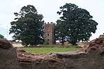 | |||
| Danderhall Miners' Club, Woolmet House Gateway And Boundary Wall | 55°55′02″N 3°06′36″W | Category A | 14184 | .jpg) | |||
| Newton Parish Church, Newton Church Road, Newton Village | 55°54′44″N 3°05′50″W | Category B | 14201 | | |||
| Chalfont, Formerly Newton Manse | 55°54′53″N 3°05′13″W | Category B | 14178 | | |||
| Newton Parish Church, Watch House, Boundary Walls And Gatepiers | 55°54′43″N 3°05′51″W | Category C(S) | 47734 | | |||
| Sheriffhall Dovecot | 55°53′59″N 3°05′18″W | Category B | 19674 | | |||
| Millerhill, Newton House, Newton Dovecot | 55°54′58″N 3°05′06″W | Category B | 14180 | | |||
| 606 Old Dalkeith Road, The Old Smithy | 55°54′47″N 3°06′55″W | Category C(S) | 43264 | | |||
| Old Dalkeith Road, Campend House, Boundary Walls, Gatepiers And Gates | 55°54′14″N 3°05′49″W | Category C(S) | 47735 | |
Key
The scheme for classifying buildings in Scotland is:
- Category A: "buildings of national or international importance, either architectural or historic; or fine, little-altered examples of some particular period, style or building type."[1]
- Category B: "buildings of regional or more than local importance; or major examples of some particular period, style or building type, which may have been altered."[1]
- Category C: "buildings of local importance; lesser examples of any period, style, or building type, as originally constructed or moderately altered; and simple traditional buildings which group well with other listed buildings."[1]
In March 2016 there were 47,288 listed buildings in Scotland. Of these, 8% were Category A, and 50% were Category B, with the remaining 42% being Category C.[2]
gollark: It "only" uses 500MB or so per firefox tab.
gollark: I still use ls like a ls-using person.
gollark: The best part of PotatOS is PotatoBIOS, which is 1900 lines and does all the in sandbox initialization.
gollark: `ls -A` > `ls -a`
gollark: The magnetic swipe card things are neat.
Notes
- Sometimes known as OSGB36, the grid reference (where provided) is based on the British national grid reference system used by the Ordnance Survey.
• "Guide to National Grid". Ordnance Survey. Retrieved 2007-12-12.
• "Get-a-map". Ordnance Survey. Retrieved 2007-12-17. - Historic Environment Scotland assign a unique alphanumeric identifier to each designated site in Scotland, for listed buildings this always begins with "LB", for example "LB12345".
References
- All entries, addresses and coordinates are based on data from Historic Scotland. This data falls under the Open Government Licence
- "What is Listing?". Historic Environment Scotland. Retrieved 29 May 2018.
- Scotland's Historic Environment Audit 2016 (PDF). Historic Environment Scotland and the Built Environment Forum Scotland. pp. 15–16. Retrieved 29 May 2018.
This article is issued from Wikipedia. The text is licensed under Creative Commons - Attribution - Sharealike. Additional terms may apply for the media files.