List of listed buildings in Newmilns And Greenholm, East Ayrshire
This is a list of listed buildings in the parish of Newmilns And Greenholm in East Ayrshire, Scotland.
List
| Name | Location | Date Listed | Grid Ref. [note 1] | Geo-coordinates | Notes | LB Number [note 2] | Image |
|---|---|---|---|---|---|---|---|
| Clydesdale And North Of Scotland Bank Ltd., Main Street | 55°36′27″N 4°19′28″W | Category B | 38610 |  | |||
| Royal Bank Of Scotland, 1 Brown's Road And Lamlash House 1 Brown Street | 55°36′24″N 4°19′36″W | Category B | 38619 | | |||
| Covenanter's Hotel,111-123 Main Street And King Street | 55°36′28″N 4°19′21″W | Category C(S) | 38617 | | |||
| Newmilns Tower To Rear Of Loudoun Arms, Castle Street | 55°36′28″N 4°19′30″W | Category B | 38606 | 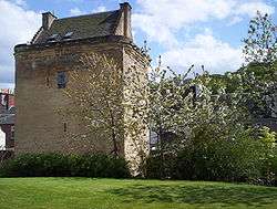 | |||
| 32, 34 And 36 Main Street | 55°36′26″N 4°19′33″W | Category C(S) | 46291 | | |||
| Nos 52, 54, 56, 58, 60, 62, 64 And 66 Main Street | 55°36′26″N 4°19′30″W | Category B | 38608 | | |||
| 30 High Street | 55°36′29″N 4°19′28″W | Category B | 46290 | | |||
| 93-95 (Odd Numbers) Main Street | 55°36′28″N 4°19′25″W | Category C(S) | 38611 | | |||
| Old Council House, Main Street | 55°36′26″N 4°19′31″W | Category B | 38607 | | |||
| 41, 43 And 45 Main Street | 55°36′27″N 4°19′33″W | Category C(S) | 46292 | | |||
| Newmilns, 72 Main Street, Brown's Institute With Courtyard Wall And Gatepiers | 55°36′27″N 4°19′28″W | Category C(S) | 44725 | | |||
| Lady Flora's School, Main Street | 55°36′29″N 4°19′18″W | Category B | 38612 | 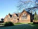 | |||
| Railway Viaduct | 55°36′26″N 4°19′13″W | Category B | 38615 | 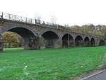 | |||
| 26-28 (Even Nos) High Street | 55°36′29″N 4°19′28″W | Category C(S) | 46289 | | |||
| Westgate Co-Operative Society Building, 25-35 (Odd Nos) Main Street And Kilnholm Street | 55°36′27″N 4°19′34″W | Category B | 38618 | | |||
| Loudoun Old Parish Church, Main Street, And Graveyard | 55°36′27″N 4°19′23″W | Category B | 38605 | | |||
| Flour Mill, Ladeside Bottom Of Union St | 55°36′22″N 4°18′56″W | Category B | 38614 | | |||
| Craigview Bridge | 55°36′25″N 4°19′26″W | Category B | 38616 | | |||
| 73-77 (Odd Nos) Main Street, Newmilns | 55°36′27″N 4°19′28″W | Category B | 43478 | | |||
| Loudoun Arms | 55°36′27″N 4°19′29″W | Category B | 38609 | | |||
| Townhead Farm | 55°36′24″N 4°18′55″W | Category B | 38613 | |
Key
The scheme for classifying buildings in Scotland is:
- Category A: "buildings of national or international importance, either architectural or historic; or fine, little-altered examples of some particular period, style or building type."[1]
- Category B: "buildings of regional or more than local importance; or major examples of some particular period, style or building type, which may have been altered."[1]
- Category C: "buildings of local importance; lesser examples of any period, style, or building type, as originally constructed or moderately altered; and simple traditional buildings which group well with other listed buildings."[1]
In March 2016 there were 47,288 listed buildings in Scotland. Of these, 8% were Category A, and 50% were Category B, with the remaining 42% being Category C.[2]
gollark: I'm sure I could get a copy if I cared.
gollark: Vaguely. It's meant to be some sort of text on bomb-making and stuff, but has been criticized for actually being pretty inaccurate a lot of the time and apparently maybe having edited wrong-er copies floating around.
gollark: I don't really care very much either way. Also, "know too much"?
gollark: ... you know people can read the filenames right?
gollark: A better reason would be that it's not really ethical, but...
Notes
- Sometimes known as OSGB36, the grid reference (where provided) is based on the British national grid reference system used by the Ordnance Survey.
• "Guide to National Grid". Ordnance Survey. Retrieved 2007-12-12.
• "Get-a-map". Ordnance Survey. Retrieved 2007-12-17. - Historic Environment Scotland assign a unique alphanumeric identifier to each designated site in Scotland, for listed buildings this always begins with "LB", for example "LB12345".
References
- All entries, addresses and coordinates are based on data from Historic Scotland. This data falls under the Open Government Licence
- "What is Listing?". Historic Environment Scotland. Retrieved 29 May 2018.
- Scotland's Historic Environment Audit 2016 (PDF). Historic Environment Scotland and the Built Environment Forum Scotland. pp. 15–16. Retrieved 29 May 2018.
This article is issued from Wikipedia. The text is licensed under Creative Commons - Attribution - Sharealike. Additional terms may apply for the media files.