List of listed buildings in Newbattle, Midlothian
List
| Name | Location | Date Listed | Grid Ref. [note 1] | Geo-coordinates | Notes | LB Number [note 2] | Image |
|---|---|---|---|---|---|---|---|
| Newbattle Abbey Policies, South Sundial | 55°52′58″N 3°03′56″W | Category A | 14563 | .jpg) | |||
| Newbattle Abbey Policies, Maiden Bridge | 55°53′16″N 3°03′43″W | Category S | 14564 |  | |||
| Gorebridge, 70, 72, 74, Hunterfield Road, Newbyres Row | 55°50′42″N 3°03′02″W | Category C(S) | 46964 | | |||
| Newbattle, Newbattle Road, Newbattle Graveyard Including Boundary Walls | 55°53′04″N 3°04′16″W | Category B | 46970 | | |||
| Newtongrange, Main Street, Newtongrange Parish Church (Church Of Scotland) Including Church Hall And Boundary Wall | 55°51′59″N 3°03′58″W | Category C(S) | 46972 | 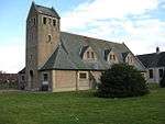 | |||
| Newbattle, Newbattle Road, Lamb's Nursery, Former Newbattle Abbey Walled Garden | 55°53′08″N 3°04′15″W | Category B | 19485 | | |||
| Newbattle, Newbattle Road, Newbattle Abbey Gardens, Archbishop Leighton's House | 55°53′03″N 3°04′09″W | Category B | 14543 | | |||
| Newtongrange, 1 - 12 (Inclusive Numbers) Lingerwood Cottages Including Boundary Wall | 55°51′42″N 3°03′53″W | Category C(S) | 14602 | | |||
| Gorebridge, Hunterfield Road, Gorebridge Parish Church (Church Of Scotland) Including Church Hall And Boundary Wall | 55°50′46″N 3°03′03″W | Category C(S) | 46965 | 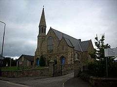 | |||
| Newbattle Road And Abbey Road, Gatepiers And Quadrant Walls | 55°53′12″N 3°04′28″W | Category C(S) | 46969 | | |||
| Newbattle Abbey Policies, Fernery | 55°53′05″N 3°04′11″W | Category B | 19257 | | |||
| Newbattle, Newbattle Road, Newbattle Parish Church (Church Of Scotland) | 55°52′59″N 3°04′15″W | Category B | 14558 | 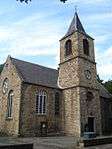 | |||
| Newbattle, Newbattle Road, Old Bridge | 55°52′48″N 3°04′13″W | Category A | 14568 | 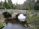 | |||
| Newbattle, Newbattle Road, 1 - 5 (Inclusive Numbers) Riverside Cottages | 55°52′50″N 3°04′14″W | Category B | 14569 | | |||
| Blinkbonny Farmhouse And Steading, Including Chimneystack | 55°51′11″N 3°01′18″W | Category C(S) | 46960 | | |||
| Southside Including Boundary Wall | 55°51′49″N 3°00′33″W | Category B | 14546 | | |||
| Newtongrange, 37 - 42 (Inclusive Numbers) Main Street, Monkwood | 55°52′02″N 3°04′00″W | Category C(S) | 14601 | | |||
| Newtongrange, Lady Victoria Colliery, Manager's Office | 55°51′43″N 3°03′54″W | Category B | 14603 | | |||
| Fordel Mains Farmhouse Including Walled Garden | 55°53′21″N 2°59′51″W | Category C(S) | 46962 | | |||
| Fordel Park, Walled Garden | 55°53′43″N 2°59′09″W | Category C(S) | 46963 | | |||
| Newtongrange, Main Street, The Dean Tavern | 55°52′08″N 3°04′08″W | Category C(S) | 46971 | | |||
| Lothianbridge, Newbattle Viaduct | 55°52′19″N 3°04′38″W | Category B | 14544 | | |||
| Lothianbridge, The Sun Inn | 55°52′22″N 3°04′41″W | Category C(S) | 14545 | | |||
| Newbattle Abbey Policies, Grotto And Ice-House | 55°52′54″N 3°04′03″W | Category B | 14565 | | |||
| Fordel Dean, Including Ancillary Buildings And Boundary Wall | 55°53′17″N 2°59′04″W | Category C(S) | 46961 | | |||
| Newbattle, Newbattle Road, Newbattle House Including Boundary Wall | 55°52′58″N 3°04′15″W | Category B | 14559 | | |||
| Newbattle, Newbattle Abbey | 55°52′58″N 3°04′01″W | Category A | 14561 | 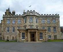 | |||
| Newbattle Abbey Policies, Newbattle Road, Monkland Wall | 55°52′52″N 3°04′15″W | Category A | 14566 | | |||
| Newbattle Abbey Policies, Port Lodge Including Quadrant Colonnades And Gatepiers | 55°52′53″N 3°04′15″W | Category A | 14567 |  | |||
| Easthouses Colliery, Airshaft East Of Kippilaw | 55°53′10″N 3°02′30″W | Category C(S) | 49651 | | |||
| Newbattle, 20 Newbattle Road, The Old Sun Inn | 55°52′54″N 3°04′17″W | Category B | 14560 | | |||
| Newbattle Abbey Policies, North Sundial | 55°53′00″N 3°03′58″W | Category A | 14562 | .jpg) | |||
| Lothianbridge, Craigesk House Including Boundary Wall And Entrance Gates | 55°52′18″N 3°04′44″W | Category C(S) | 46966 | | |||
| Newbattle Abbey Policies, Lothian Burial Ground | 55°53′02″N 3°04′09″W | Category C(S) | 46967 | |
Key
The scheme for classifying buildings in Scotland is:
- Category A: "buildings of national or international importance, either architectural or historic; or fine, little-altered examples of some particular period, style or building type."[1]
- Category B: "buildings of regional or more than local importance; or major examples of some particular period, style or building type, which may have been altered."[1]
- Category C: "buildings of local importance; lesser examples of any period, style, or building type, as originally constructed or moderately altered; and simple traditional buildings which group well with other listed buildings."[1]
In March 2016 there were 47,288 listed buildings in Scotland. Of these, 8% were Category A, and 50% were Category B, with the remaining 42% being Category C.[2]
gollark: Yes you can.
gollark: Half is only something like 0.3 of an order of magnitude.
gollark: If people cannot cope with slightly odd messages, how will they deal with esoteric programming languages?
gollark: Not really conformity, normal-looking-ness.
gollark: Well, I think optimizing for conformity actually bad.
Notes
- Sometimes known as OSGB36, the grid reference (where provided) is based on the British national grid reference system used by the Ordnance Survey.
• "Guide to National Grid". Ordnance Survey. Retrieved 2007-12-12.
• "Get-a-map". Ordnance Survey. Retrieved 2007-12-17. - Historic Environment Scotland assign a unique alphanumeric identifier to each designated site in Scotland, for listed buildings this always begins with "LB", for example "LB12345".
References
- All entries, addresses and coordinates are based on data from Historic Scotland. This data falls under the Open Government Licence
- "What is Listing?". Historic Environment Scotland. Retrieved 29 May 2018.
- Scotland's Historic Environment Audit 2016 (PDF). Historic Environment Scotland and the Built Environment Forum Scotland. pp. 15–16. Retrieved 29 May 2018.
This article is issued from Wikipedia. The text is licensed under Creative Commons - Attribution - Sharealike. Additional terms may apply for the media files.