List of listed buildings in Morham, East Lothian
List
| Name | Location | Date Listed | Grid Ref. [note 1] | Geo-coordinates | Notes | LB Number [note 2] | Image |
|---|---|---|---|---|---|---|---|
| Mainshill Farm Cottages | 55°56′27″N 2°42′13″W | Category B | 18863 |  | |||
| Morham Loanhead | 55°56′14″N 2°43′01″W | Category C(S) | 18865 | | |||
| The Old Manse | 55°56′37″N 2°42′45″W | Category B | 18868 | | |||
| Morham Mains Farmhouse With Retaining Walls | 55°56′08″N 2°42′49″W | Category B | 18867 | | |||
| Renton Hall Cottage | 55°56′20″N 2°43′51″W | Category C(S) | 18872 | | |||
| West Morham Farmhouse | 55°56′02″N 2°44′06″W | Category B | 18875 | | |||
| Beech Hill Lodge And Gatepiers | 55°55′34″N 2°44′10″W | Category B | 18862 | | |||
| Morham Bank Farmhouse With Walled Garden, Terrace Wall And Piers | 55°55′31″N 2°43′41″W | Category B | 18864 | | |||
| Morham Mains Cottages | 55°56′12″N 2°43′00″W | Category B | 18866 | | |||
| Morham Mill Bridge | 55°56′23″N 2°42′31″W | Category B | 18869 | | |||
| Standingstone Farmhouse With Piers And Retaining Walls | 55°57′13″N 2°40′45″W | Category C(S) | 18874 | | |||
| Renton Hall With Walled Garden And Gatepiers | 55°56′16″N 2°43′52″W | Category B | 18871 | | |||
| Standing Stone Farm Cottages With Retaining Walls | 55°57′13″N 2°40′46″W | Category C(S) | 18873 | | |||
| Morham Parish Church With Graveyard Walls | 55°56′40″N 2°42′41″W | Category A | 18870 | 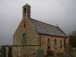 |
Key
The scheme for classifying buildings in Scotland is:
- Category A: "buildings of national or international importance, either architectural or historic; or fine, little-altered examples of some particular period, style or building type."[1]
- Category B: "buildings of regional or more than local importance; or major examples of some particular period, style or building type, which may have been altered."[1]
- Category C: "buildings of local importance; lesser examples of any period, style, or building type, as originally constructed or moderately altered; and simple traditional buildings which group well with other listed buildings."[1]
In March 2016 there were 47,288 listed buildings in Scotland. Of these, 8% were Category A, and 50% were Category B, with the remaining 42% being Category C.[2]
gollark: osmarkslisp™ was written prior to the contest, you know.
gollark: It obviously can. Click it.
gollark: They ought to at least have allowed Macron.
gollark: I have used z3 before, you know.
gollark: It does depend on your relativistic frame of reference.
Notes
- Sometimes known as OSGB36, the grid reference (where provided) is based on the British national grid reference system used by the Ordnance Survey.
• "Guide to National Grid". Ordnance Survey. Retrieved 2007-12-12.
• "Get-a-map". Ordnance Survey. Retrieved 2007-12-17. - Historic Environment Scotland assign a unique alphanumeric identifier to each designated site in Scotland, for listed buildings this always begins with "LB", for example "LB12345".
References
- All entries, addresses and coordinates are based on data from Historic Scotland. This data falls under the Open Government Licence
- "What is Listing?". Historic Environment Scotland. Retrieved 29 May 2018.
- Scotland's Historic Environment Audit 2016 (PDF). Historic Environment Scotland and the Built Environment Forum Scotland. pp. 15–16. Retrieved 29 May 2018.
This article is issued from Wikipedia. The text is licensed under Creative Commons - Attribution - Sharealike. Additional terms may apply for the media files.