List of listed buildings in Monifieth, Angus
List
| Name | Location | Date Listed | Grid Ref. [note 1] | Geo-coordinates | Notes | LB Number [note 2] | Image |
|---|---|---|---|---|---|---|---|
| 62 Hill Street, Viewfirth | 56°29′00″N 2°49′03″W | Category C(S) | 37971 |  | |||
| Victoria Street, Ashlea, With 2 Sets Of Gatepiers And Wall And Enclosing Wall To North And East | 56°28′57″N 2°49′16″W | Category C(S) | 37981 | | |||
| Kingennie, Kingennie House | 56°30′26″N 2°51′04″W | Category B | 17463 | | |||
| Laws Hill, 'Bone-House' | 56°30′13″N 2°49′39″W | Category B | 17465 | | |||
| Church Street, St Rule's Parish Church With Churchyard | 56°28′50″N 2°49′16″W | Category B | 37955 | | |||
| Hill Street, Lamp Standard At No 10 | 56°28′49″N 2°49′24″W | Category B | 37966 | | |||
| Hill Street, Seaview, Including Balustrade, Terrace Wall And Garden Wall With Gatepiers | 56°28′55″N 2°49′20″W | Category B | 37968 | | |||
| 20 Union Street, Station House | 56°28′47″N 2°49′07″W | Category B | 37979 | | |||
| Union Street, Monifieth Station, Footbridge Over Railway | 56°28′48″N 2°49′03″W | Category C(S) | 37980 | | |||
| Victoria Street, Ashludie, Walled Garden And Conservatory | 56°29′20″N 2°49′24″W | Category B | 37985 | | |||
| Former Monifieth North (Hillock) Church With Gatepiers And Walls | 56°29′52″N 2°51′32″W | Category B | 17468 | | |||
| South Grange Farm, Horse Mill | 56°29′13″N 2°50′01″W | Category C(S) | 17469 | | |||
| Wellbank, Wellbank Farm House | 56°31′33″N 2°52′11″W | Category B | 17470 | | |||
| Drumsturdy Road, Cunmont Cottages West | 56°30′34″N 2°49′40″W | Category B | 17481 | | |||
| 76 Hill Street, Greenbourne | 56°29′05″N 2°48′55″W | Category B | 37972 | | |||
| Ferry Road, Grange Works (Former Milton Tram Depot) | 56°28′36″N 2°50′02″W | Category B | 37958 | | |||
| Grange Road, 1 And 2 Paradise Cottages, Boundary Wall At North | 56°28′54″N 2°50′01″W | Category B | 37961 | | |||
| Grange Road, The Grange Lodge, Including Gatepiers | 56°29′06″N 2°49′57″W | Category C(S) | 37963 | | |||
| High Street, Holy Trinity Episcopal Church With Enclosing Wall And Gates | 56°29′02″N 2°48′55″W | Category B | 37964 | | |||
| Queen Street, Tighnduin | 56°28′55″N 2°49′30″W | Category B | 37978 | | |||
| 4 Victoria Street, Tigh-Na-Muirn, Motor House, Game Larder, Lamp Standard, Enclosing Walls At North, South, East And West, And Gatepiers At Victoria Street | 56°29′00″N 2°49′16″W | Category B | 37982 | | |||
| Victoria Street, Ashludie Stable Court | 56°29′21″N 2°49′20″W | Category C(S) | 37984 | | |||
| Laws Hill, Lodge And Gatepiers To Demolished Laws House | 56°30′09″N 2°49′35″W | Category B | 19802 | | |||
| Laws Hill, Stable Court To Demolished Laws House | 56°30′13″N 2°49′51″W | Category B | 17466 | | |||
| Albert Street, Railway Footbridge | 56°28′43″N 2°49′26″W | Category B | 37954 | | |||
| Church Street, Former Manse | 56°28′52″N 2°49′16″W | Category B | 37956 | | |||
| Church Street, Gerard Hall | 56°28′49″N 2°49′14″W | Category B | 37957 | | |||
| Ferry Road, Milton Mill | 56°28′37″N 2°50′03″W | Category B | 37959 | | |||
| Grange Road, Milton House Hotel | 56°28′49″N 2°50′01″W | Category B | 37960 | | |||
| Hill Street, Lamp Standard At No 50 | 56°28′58″N 2°49′08″W | Category B | 37970 | | |||
| Maule Street, Invertay House, Former Invertay Primary School And School House | 56°28′49″N 2°49′10″W | Category B | 37974 | | |||
| Princes Street, Ladies' Panmure Golf Club | 56°28′55″N 2°48′47″W | Category B | 37977 | | |||
| Victoria Street, Ashludie With Enclosing Wall To Victoria Street | 56°29′20″N 2°49′16″W | Category B | 37983 | | |||
| Hill Street, South Church | 56°28′52″N 2°49′22″W | Category C(S) | 37967 | | |||
| 50 Hill Street | 56°28′58″N 2°49′08″W | Category C(S) | 37969 | | |||
| Maule Street, War Memorial | 56°28′46″N 2°49′26″W | Category B | 37973 | 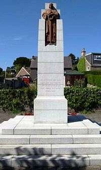 | |||
| Monifieth Golf Course Starters Box At Medal Course, Near Panmure Hotel | 56°28′53″N 2°48′41″W | Category C(S) | 37975 | | |||
| Panmurefield Road, Lamp Standard At No 5 | 56°28′38″N 2°50′18″W | Category B | 37976 | | |||
| Kingennie, Kingennie House, The Gardens | 56°30′23″N 2°51′14″W | Category C(S) | 17464 | | |||
| Laws Hill, Laws Farm Granary And Yard | 56°30′18″N 2°49′34″W | Category B | 17467 | | |||
| Drumsturdy Road, The Harrow's, Omachie Lodge West | 56°30′23″N 2°50′40″W | Category C(S) | 17483 | | |||
| 4 Hill Street With Wall And Gatepiers, And Similar Wall And Gatepiers Leading To Maule Street | 56°28′48″N 2°49′25″W | Category C(S) | 37965 | | |||
| Victoria Street, Ashludie, South Lodge And Gatepiers | 56°29′14″N 2°49′25″W | Category C(S) | 37986 | | |||
| Drumsturdy Road, Linlathen North Lodge, Linlathen | 56°29′40″N 2°52′33″W | Category C(S) | 17461 | | |||
| Kincordie House Including Coach House And Wall, Former Monifieth North (Hillock) Manse | 56°29′53″N 2°51′30″W | Category C(S) | 17462 | | |||
| Drumsturdy Road, Laws Lodge And Gatepiers | 56°30′22″N 2°50′38″W | Category C(S) | 17482 | | |||
| The Grange With Gatepiers | 56°29′09″N 2°49′51″W | Category C(S) | 37962 | |
Key
The scheme for classifying buildings in Scotland is:
- Category A: "buildings of national or international importance, either architectural or historic; or fine, little-altered examples of some particular period, style or building type."[1]
- Category B: "buildings of regional or more than local importance; or major examples of some particular period, style or building type, which may have been altered."[1]
- Category C: "buildings of local importance; lesser examples of any period, style, or building type, as originally constructed or moderately altered; and simple traditional buildings which group well with other listed buildings."[1]
In March 2016 there were 47,288 listed buildings in Scotland. Of these, 8% were Category A, and 50% were Category B, with the remaining 42% being Category C.[2]
gollark: I was thinking of various methods of evilness involving global state.
gollark: Interesting idea.
gollark: What does time-machine do? Tit-for-tat but looking back two moves?
gollark: If I run them for 100 rounds, then grudger wins substantially.
gollark: It is -2.
See also
Notes
- Sometimes known as OSGB36, the grid reference (where provided) is based on the British national grid reference system used by the Ordnance Survey.
• "Guide to National Grid". Ordnance Survey. Retrieved 2007-12-12.
• "Get-a-map". Ordnance Survey. Retrieved 2007-12-17. - Historic Environment Scotland assign a unique alphanumeric identifier to each designated site in Scotland, for listed buildings this always begins with "LB", for example "LB12345".
References
- All entries, addresses and coordinates are based on data from Historic Scotland. This data falls under the Open Government Licence
- "What is Listing?". Historic Environment Scotland. Retrieved 29 May 2018.
- Scotland's Historic Environment Audit 2016 (PDF). Historic Environment Scotland and the Built Environment Forum Scotland. pp. 15–16. Retrieved 29 May 2018.
This article is issued from Wikipedia. The text is licensed under Creative Commons - Attribution - Sharealike. Additional terms may apply for the media files.