List of listed buildings in Mearns, East Renfrewshire
List
| Name | Location | Date Listed | Grid Ref. [note 1] | Geo-coordinates | Notes | LB Number [note 2] | Image |
|---|---|---|---|---|---|---|---|
| Mearnskirk Hospital, Former Nurses' Home Administration Block Former Domestic Residence General Store House Lodge And Southfield House | 55°45′47″N 4°19′59″W | Category B | 19215 |  | |||
| Ayr Road, No 71 Newton Mearns | 55°47′01″N 4°18′48″W | Category B | 18526 | | |||
| Aurs Road, Balgray Reservoir Draw-Off Tower | 55°47′00″N 4°21′55″W | Category B | 51185 | | |||
| Robert Pollock Monument, At Junction Of Old Mearns Road With Ayr Road Near Loganswell | 55°44′37″N 4°21′54″W | Category C(S) | 19889 | 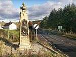 | |||
| Newton Mearns Broom Road East Kirkhill House | 55°46′29″N 4°18′14″W | Category B | 18524 | | |||
| Ayr Road, Fa'side House | 55°45′53″N 4°20′48″W | Category B | 18527 | | |||
| Church Of Maxwell, Mearns Castle, Broom Road, By Newton Mearns | 55°46′11″N 4°18′33″W | Category A | 18536 | 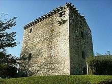 | |||
| "Croyland", No. 202 Ayr Road, Newton Mearns | 55°46′31″N 4°19′41″W | Category B | 18531 | | |||
| Balgray House, Off Stewarton Road (B769) | 55°46′46″N 4°22′22″W | Category B | 18533 | | |||
| "Holytree" (Formerly "Todhill"), Capelrig Road By Newton Mearns | 55°46′47″N 4°19′51″W | Category B | 18529 | | |||
| Humbie Road, Kirkhouse Newton Mearns | 55°46′00″N 4°19′21″W | Category B | 18534 | | |||
| Ayr Road, Gates And Gatepiers At No 71. Newton Mearns | 55°47′01″N 4°18′48″W | Category C(S) | 18525 | | |||
| Capelrig, Capelrig Road, By Newton Mearns | 55°47′12″N 4°19′36″W | Category A | 18523 | | |||
| Belmont House School, Formerly "Broom House", Sandringham Avenue, Newton Mearns | 55°46′53″N 4°18′48″W | Category B | 18528 | | |||
| Mearns Kirk, Mearnskirk Newton Mearns | 55°46′01″N 4°19′30″W | Category B | 18532 | 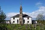 |
Key
The scheme for classifying buildings in Scotland is:
- Category A: "buildings of national or international importance, either architectural or historic; or fine, little-altered examples of some particular period, style or building type."[1]
- Category B: "buildings of regional or more than local importance; or major examples of some particular period, style or building type, which may have been altered."[1]
- Category C: "buildings of local importance; lesser examples of any period, style, or building type, as originally constructed or moderately altered; and simple traditional buildings which group well with other listed buildings."[1]
In March 2016 there were 47,288 listed buildings in Scotland. Of these, 8% were Category A, and 50% were Category B, with the remaining 42% being Category C.[2]
gollark: But yes, something something tradeoffs. You can get powerful thin laptops too, but they cost more than a bad thin laptop or powerful nonthin laptop.
gollark: A desktop is portable, just glue a car battery and 23" monitor to the side.
gollark: Unfortunately, they cost a lot (the M1 is very much not optimized for cost, and Apple like charging lots), run MacOS, and cannot be repaired.
gollark: As well as good power efficiency they also have possibly the best single-threaded performance of any mobile thing.
gollark: The new ones have rather good GPUs, too.
Notes
- Sometimes known as OSGB36, the grid reference (where provided) is based on the British national grid reference system used by the Ordnance Survey.
• "Guide to National Grid". Ordnance Survey. Retrieved 2007-12-12.
• "Get-a-map". Ordnance Survey. Retrieved 2007-12-17. - Historic Environment Scotland assign a unique alphanumeric identifier to each designated site in Scotland, for listed buildings this always begins with "LB", for example "LB12345".
References
- All entries, addresses and coordinates are based on data from Historic Scotland. This data falls under the Open Government Licence
- "What is Listing?". Historic Environment Scotland. Retrieved 29 May 2018.
- Scotland's Historic Environment Audit 2016 (PDF). Historic Environment Scotland and the Built Environment Forum Scotland. pp. 15–16. Retrieved 29 May 2018.
This article is issued from Wikipedia. The text is licensed under Creative Commons - Attribution - Sharealike. Additional terms may apply for the media files.