List of listed buildings in Marnoch, Aberdeenshire
List
| Name | Location | Date Listed | Grid Ref. [note 1] | Geo-coordinates | Notes | LB Number [note 2] | Image |
|---|---|---|---|---|---|---|---|
| Netherdale, Barnyards Of Netherdale, Dovecot | 57°31′42″N 2°35′14″W | Category C(S) | 19617 |  | |||
| Netherdale Walled Garden, Summerhouse Sundial And Gatepiers | 57°31′44″N 2°35′00″W | Category B | 19620 | | |||
| Culvie With Steading And Walled Garden | 57°34′16″N 2°41′04″W | Category B | 19603 | | |||
| Marnoch Graveyard With Watchhouse, Burial Enclosures And Gravestones | 57°32′16″N 2°40′42″W | Category A | 19610 | | |||
| Kinnairdy Castle With Outbuildings | 57°32′12″N 2°39′17″W | Category A | 19606 | 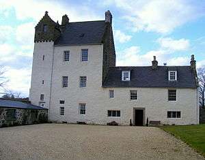 | |||
| Marnoch, Old Church With Retaining Wall, Standing Stones And Mounting Block | 57°32′24″N 2°40′29″W | Category B | 19611 | 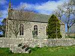 | |||
| Mill Of Alliehar | 57°34′42″N 2°38′49″W | Category C(S) | 19614 | | |||
| Auldtown Of Netherdale Steading | 57°31′13″N 2°36′30″W | Category C(S) | 16023 | | |||
| Clunie Home Farm | 57°32′25″N 2°36′27″W | Category B | 16027 | | |||
| Ardmeallie House With Steading Range, Coachhouse, Boundary Walls And Gatepiers | 57°32′38″N 2°41′05″W | Category B | 16028 | | |||
| Netherdale House, Coachhouse Stable And Coachman's House, And Garage | 57°31′30″N 2°34′57″W | Category B | 19619 | | |||
| Janefield | 57°32′56″N 2°38′52″W | Category B | 19605 | | |||
| Kinnairdy Castle, Dovecot And Walled Garden | 57°32′11″N 2°39′18″W | Category B | 19607 | | |||
| Marnoch, Old Schoolhouse | 57°32′19″N 2°40′25″W | Category B | 19613 | | |||
| Auchintoul, Mains Of Auchintoul - Smithy | 57°33′32″N 2°38′48″W | Category C(S) | 16032 | | |||
| House Of Glennie With Garden Walls And Gates And Gatepiers | 57°31′58″N 2°41′56″W | Category B | 19604 | | |||
| Mill Of Kinnairdy Bridge | 57°32′21″N 2°39′00″W | Category C(S) | 19615 | | |||
| Clunie | 57°32′24″N 2°36′32″W | Category B | 16025 | | |||
| Auchintoul, Mains Of Auchintoul, Farmhouse With Garden Walls | 57°33′32″N 2°38′48″W | Category B | 16031 | | |||
| Clunie Walled Garden | 57°32′23″N 2°36′25″W | Category C(S) | 19601 | | |||
| Lootcherbrae, Smithy | 57°34′29″N 2°39′38″W | Category C(S) | 19609 | | |||
| Auchintoul, South Lodge With Gates And Gatepiers | 57°33′08″N 2°38′59″W | Category B | 16020 | | |||
| Clunie Dovecot | 57°32′24″N 2°36′17″W | Category C(S) | 16026 | | |||
| Mill Of Kinnairdy, Miller's House | 57°32′21″N 2°39′05″W | Category C(S) | 19616 | | |||
| Netherdale House | 57°31′27″N 2°34′58″W | Category B | 19618 | | |||
| Crombie Castle | 57°33′31″N 2°41′07″W | Category A | 19602 | | |||
| Auchintoul, Mill Of Auchintoul | 57°33′04″N 2°38′58″W | Category B | 16033 | 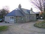 | |||
| Auchintoul With Courtyard Walls | 57°33′21″N 2°38′54″W | Category B | 16030 | | |||
| Longlaugh | 57°31′32″N 2°38′18″W | Category C(S) | 19608 | | |||
| Auchintoul, Walled Garden And Sundial | 57°33′27″N 2°38′49″W | Category B | 16021 | | |||
| Chapeltown | 57°30′57″N 2°37′33″W | Category C(S) | 16024 | | |||
| Ardmeallie Walled Garden With Summerhouse And Sundial | 57°32′40″N 2°41′08″W | Category B | 16029 | | |||
| Auchintoul, Mains Of Auchintoul - Steading | 57°33′31″N 2°38′48″W | Category B | 19771 | | |||
| Marnoch, Old Manse Of Marnoch With Outbuildings And Garden Walls | 57°32′21″N 2°40′47″W | Category B | 19612 | 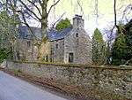 | |||
| Auldtown Of Netherdale With Coachhouse | 57°31′12″N 2°36′21″W | Category B | 16022 | |
Key
The scheme for classifying buildings in Scotland is:
- Category A: "buildings of national or international importance, either architectural or historic; or fine, little-altered examples of some particular period, style or building type."[1]
- Category B: "buildings of regional or more than local importance; or major examples of some particular period, style or building type, which may have been altered."[1]
- Category C: "buildings of local importance; lesser examples of any period, style, or building type, as originally constructed or moderately altered; and simple traditional buildings which group well with other listed buildings."[1]
In March 2016 there were 47,288 listed buildings in Scotland. Of these, 8% were Category A, and 50% were Category B, with the remaining 42% being Category C.[2]
gollark: That's one of the existent ones I'm aware of, and it has WiFi, so sure?
gollark: Unless you mean the actual processor chip, no, what you probably want is a microcontroller thing.
gollark: ESPsomething microcontroller boards?
gollark: The zero W?
gollark: Degrading flash memory probably *should* just become unwritable or something.
Notes
- Sometimes known as OSGB36, the grid reference (where provided) is based on the British national grid reference system used by the Ordnance Survey.
• "Guide to National Grid". Ordnance Survey. Retrieved 2007-12-12.
• "Get-a-map". Ordnance Survey. Retrieved 2007-12-17. - Historic Environment Scotland assign a unique alphanumeric identifier to each designated site in Scotland, for listed buildings this always begins with "LB", for example "LB12345".
References
- All entries, addresses and coordinates are based on data from Historic Scotland. This data falls under the Open Government Licence
- "What is Listing?". Historic Environment Scotland. Retrieved 29 May 2018.
- Scotland's Historic Environment Audit 2016 (PDF). Historic Environment Scotland and the Built Environment Forum Scotland. pp. 15–16. Retrieved 29 May 2018.
This article is issued from Wikipedia. The text is licensed under Creative Commons - Attribution - Sharealike. Additional terms may apply for the media files.