List of listed buildings in Markinch, Fife
List
| Name | Location | Date Listed | Grid Ref. [note 1] | Geo-coordinates | Notes | LB Number [note 2] | Image |
|---|---|---|---|---|---|---|---|
| Windygates, Cameron Hospital, Pavilion Wards And Lodges 2 And 3 | 56°11′14″N 3°03′26″W | Category B | 43384 |  | |||
| Carriston With Walled Garden, Bee Boles, Boundary Walls, Gates And Railings | 56°13′28″N 3°05′33″W | Category B | 42971 | | |||
| Coaltown Of Balgonie, 88 Main Street, East House With Outbuildings, Boundary Wall, Gatepiers, Gates And Railings | 56°11′03″N 3°07′49″W | Category B | 42973 | | |||
| Coaltown Of Balgonie, Balgonie Cottage With Outbuilding | 56°11′28″N 3°07′20″W | Category C(S) | 42978 | | |||
| Milton Of Balgonie, Lydiard | 56°11′41″N 3°05′02″W | Category B | 42989 | | |||
| Thornton, Main Street, Crown Hotel | 56°09′51″N 3°08′44″W | Category C(S) | 42994 | | |||
| Thornton, Park Place War Memorial | 56°09′55″N 3°08′41″W | Category C(S) | 42998 | | |||
| Windygates, Cameron House With Boundary Wall And Pier | 56°11′11″N 3°03′13″W | Category B | 43009 | | |||
| Windygates, Station Road, Mariposa And Monrepos With Boundary Walls, Piers, Railings And Gates | 56°11′31″N 3°03′15″W | Category C(S) | 43017 | | |||
| 27 Balbirnie Street With Boundary Wall | 56°12′12″N 3°08′09″W | Category C(S) | 42930 | | |||
| Balbirnie Street And Commercial Street, Royal Bank Of Scotland With Boundary Walls | 56°12′13″N 3°08′08″W | Category C(S) | 42935 | | |||
| Betson Street, Town Hall, Gatepiers And Railings | 56°12′08″N 3°08′05″W | Category C(S) | 42942 | | |||
| 2 High Street And 1 Mitchell Place | 56°12′06″N 3°07′53″W | Category C(S) | 42946 | | |||
| High Street And Union Street, The Town House | 56°12′06″N 3°07′55″W | Category C(S) | 42949 | | |||
| Balbirnie Park, West Lodge With Boundary Walls | 56°12′23″N 3°09′39″W | Category B | 16654 | | |||
| Carriston Dovecot | 56°13′26″N 3°05′27″W | Category B | 16662 | | |||
| Newton Farmhouse With Outbuilding And Boundary Wall | 56°12′44″N 3°08′09″W | Category B | 16663 | | |||
| Coul Mains With Boundary Walls | 56°12′57″N 3°09′43″W | Category B | 16668 | | |||
| Balbirnie Park, Balbirnie Stables With Boundary Wall | 56°12′29″N 3°08′43″W | Category B | 16688 | | |||
| Balbirnie Park, South Lodge With Gatepiers, Gates, Railings And Boundary Walls | 56°12′13″N 3°08′22″W | Category B | 16689 | | |||
| Brunton Walled Garden | 56°12′20″N 3°07′17″W | Category B | 42970 | | |||
| Coaltown Of Balgonie, Balgonie Cottage, Steading | 56°11′27″N 3°07′18″W | Category B | 42979 | | |||
| Coaltown Road, Former United Presbyterian Manse With Boundary Walls | 56°11′56″N 3°07′49″W | Category C(S) | 42981 | | |||
| Middle Mill And Middle Mill Cottages | 56°11′48″N 3°08′19″W | Category B | 42986 | | |||
| Thornton, Main Street, Old Parish Church With Boundary Walls | 56°09′56″N 3°08′47″W | Category C(S) | 42995 | | |||
| Windygates, Balcurvie, East Temple | 56°11′49″N 3°03′38″W | Category C(S) | 43005 | | |||
| Windygates, Haughmill Lane, Primrose Bank With Outbuilding And Boundary Wall | 56°11′31″N 3°03′17″W | Category C(S) | 43013 | | |||
| Woodlands House With Boundary Wall | 56°11′58″N 3°07′44″W | Category C(S) | 43019 | | |||
| 32 And 34 Balbirnie Street | 56°12′13″N 3°08′09″W | Category C(S) | 42931 | | |||
| Balbirnie Street And Betson Street, Laurel Bank Hotel With Boundary Walls | 56°12′12″N 3°08′07″W | Category C(S) | 42934 | | |||
| Balgonie Road And Mitchell Terrace, Markinch Railway Station With Gatepiers, Boundary Walls And Railings | 56°12′04″N 3°07′51″W | Category B | 42936 | | |||
| 2 And 4 King Edward Street With Boundary Walls | 56°12′00″N 3°08′03″W | Category C(S) | 42951 | | |||
| Northall Road, Burnside Cottage With Boundary Walls And Gate | 56°12′27″N 3°07′49″W | Category B | 42955 | | |||
| Balbirnie Park, Walled Garden | 56°12′28″N 3°08′39″W | Category B | 42964 | | |||
| Kirk Street And School Street, Galloway Inn | 56°12′21″N 3°08′05″W | Category B | 37651 | | |||
| 13 And 15 School Street With Boundary Wall | 56°12′22″N 3°08′03″W | Category C(S) | 37654 | | |||
| High Street, Brunton Court, Former United Free Church With Boundary Walls | 56°12′10″N 3°07′58″W | Category C(S) | 37673 | | |||
| Balbirnie Street, United Presbyterian Church | 56°12′12″N 3°08′16″W | Category B | 37675 | | |||
| Balbirnie Estate, Kirkforthar Dovecot | 56°13′53″N 3°08′10″W | Category B | 16660 | | |||
| 6 And 7 Gateside With Boundary Wall | 56°13′15″N 3°09′18″W | Category C(S) | 16682 | | |||
| Windygates, Cameron Hospital, Haig House With Outbuilding Boundary Wall And Railings | 56°11′15″N 3°03′25″W | Category B | 16684 | | |||
| Markinch Railway Viaduct | 56°11′48″N 3°07′56″W | Category B | 16685 | | |||
| Coaltown Of Balgonie, Main Street, Balgonie Arms With Boundary Wall | 56°11′06″N 3°07′35″W | Category C(S) | 42975 | | |||
| Duniface Farmhouse And Steading, Outbuilding, Boundary Walls, Gatepiers And Gates | 56°11′51″N 3°02′38″W | Category B | 42982 | | |||
| Milton Of Balgonie, Balfour Bridge | 56°11′34″N 3°05′26″W | Category B | 42987 | | |||
| Milton Of Balgonie, Balfour Walled Garden With Garden House | 56°11′25″N 3°05′38″W | Category B | 42988 | | |||
| Thornton, Main Street And Park Place No 60 And Royal Bank With Boundary Walls | 56°09′55″N 3°08′44″W | Category C(S) | 42997 | | |||
| Thornton, 40 Station Road With Boundary Wall | 56°10′02″N 3°08′37″W | Category C(S) | 43002 | | |||
| Windygates, Balcurvie House With Walled Garden, Boundary Walls, Gatepiers And Gates | 56°12′00″N 3°03′34″W | Category B | 43006 | | |||
| Windygates, Durie Vale, Gatepiers And Quadrant Walls | 56°11′35″N 3°03′03″W | Category B | 43011 | | |||
| 15 Commercial Street And Antique Shop With Outbuilding And Boundary Wall | 56°12′15″N 3°08′09″W | Category C(S) | 42944 | | |||
| 1, 2 And 3 Balfarg Cottages With Boundary Wall | 56°13′02″N 3°09′15″W | Category C(S) | 42965 | | |||
| Kirk Brae, St Drostan's Parish Church | 56°12′18″N 3°08′03″W | Category A | 37644 | 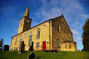 | |||
| Kirk Brae, St Drostan's Parish Church Session House | 56°12′19″N 3°08′04″W | Category B | 37646 | | |||
| 7 Kirk Street With Boundary Wall | 56°12′20″N 3°08′04″W | Category C(S) | 37649 | | |||
| 2, 2A And 4-10 (Even Nos) Croft Road | 56°12′18″N 3°08′08″W | Category C(S) | 37656 | | |||
| 1 Stobcross Road | 56°12′21″N 3°08′07″W | Category C(S) | 37667 | | |||
| Coul Farmhouse | 56°13′06″N 3°10′13″W | Category B | 16655 | | |||
| Balgonie Policies, Walled Garden | 56°11′36″N 3°06′49″W | Category B | 16665 | | |||
| Balgonie Policies, Turbine House | 56°11′42″N 3°06′45″W | Category B | 42969 | | |||
| Windygates, Cross, Clock | 56°11′33″N 3°03′15″W | Category C(S) | 43010 | | |||
| Windygates, Durie Vale House With Boundary Wall | 56°11′34″N 3°03′02″W | Category B | 43012 | | |||
| Windygates, Milton Road And Haughmill Lane, West View And Newsagent With Boundary Wall, Gatepiers | 56°11′33″N 3°03′18″W | Category C(S) | 43015 | | |||
| Windygates, Milton Road And Kennoway Road, Windygates Hotel With Outbuildings, Boundary Wall And Gatepiers | 56°11′34″N 3°03′16″W | Category C(S) | 43016 | | |||
| Balbirnie Street, War Memorial With Boundary Walls | 56°12′12″N 3°08′04″W | Category B | 42933 | | |||
| 2 Betson Street And 29 Balbirnie Street | 56°12′13″N 3°08′08″W | Category C(S) | 42937 | | |||
| 12, 14, And 16 Betson Street, Including Post Office | 56°12′11″N 3°08′08″W | Category C(S) | 42938 | | |||
| Betson Street, Markinch Centre With Boundary Walls And Lamp | 56°12′10″N 3°08′08″W | Category B | 42940 | | |||
| 72, 74 And 74A, 76, 78 High Street | 56°12′13″N 3°07′58″W | Category C(S) | 42947 | | |||
| Victoria Road, Morven With Outbuilding And Boundary Wall | 56°12′03″N 3°08′06″W | Category C(S) | 42956 | | |||
| Balbirnie Mills, Saapi Graphics, Manager's House | 56°12′02″N 3°09′04″W | Category C(S) | 42959 | | |||
| Balbirnie Park, Gamekeeper's Cottage With Boundary Walls | 56°12′40″N 3°08′23″W | Category C(S) | 42962 | | |||
| Balfarg Farmhouse With Boundary Walls | 56°12′58″N 3°09′19″W | Category C(S) | 42966 | | |||
| 13 Kirk Street, Kirkstyle | 56°12′19″N 3°08′04″W | Category C(S) | 37647 | | |||
| 9 School Street, Old Schoolhouse With Boundary Walls | 56°12′22″N 3°08′04″W | Category C(S) | 37652 | | |||
| Milton Of Balgonie, Balgonie Bridge | 56°11′30″N 3°06′06″W | Category B | 16666 | | |||
| Milton Of Balgonie, Main Street, Church Of Scotland Church With Graveyard, Boundary Walls, Gatepiers And Gates | 56°11′39″N 3°05′34″W | Category B | 16667 | 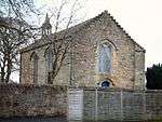 | |||
| Alburne Park, Balbirnie Bridge | 56°12′01″N 3°09′08″W | Category B | 15045 | | |||
| Balgonie Policies, Gatepiers And Boundary Walls | 56°11′34″N 3°06′29″W | Category C(S) | 42968 | | |||
| Coaltown Of Balgonie, 48 Main Street | 56°11′05″N 3°07′36″W | Category C(S) | 42972 | | |||
| Coaltown Of Balgonie, Barrel Brig | 56°10′21″N 3°07′00″W | Category B | 42980 | | |||
| Little Lun With Boundary Wall And Gatepiers | 56°11′09″N 3°04′11″W | Category B | 42985 | | |||
| Northall Cemetery With Gravestones, Boundary Walls And Gates | 56°12′34″N 3°07′46″W | Category C(S) | 42991 | | |||
| Thornton, Main Street And Chewton Road, The Clock Shop | 56°09′58″N 3°08′47″W | Category C(S) | 42996 | | |||
| Thornton, Spittal Farm With Steading And Boundary Walls | 56°09′58″N 3°07′58″W | Category C(S) | 42999 | | |||
| Woodbank With Boundary Wall, Gatepiers And Gates | 56°10′37″N 3°04′05″W | Category B | 43018 | | |||
| Betson Street, Bowling Club With Boundary, Walls, Gatepiers And Gate | 56°12′08″N 3°08′09″W | Category C(S) | 42939 | | |||
| Balbirnie Park, Balbirnie Mains Farm, Dairy With Pavilion And Boundary Walls | 56°12′39″N 3°09′07″W | Category C(S) | 42961 | | |||
| 11 Kirk Street | 56°12′20″N 3°08′04″W | Category C(S) | 37648 | | |||
| 30 Commercial Street, Radnor House With Boundary Walls, Gates And Gatepiers | 56°12′17″N 3°08′07″W | Category B | 37663 | | |||
| 5 Stobcross Road, The Cottage With Boundary Walls | 56°12′22″N 3°08′07″W | Category C(S) | 37668 | | |||
| Coul Steadings, Nos 4, 5, 6 And 7 | 56°13′06″N 3°10′13″W | Category C(S) | 16656 | | |||
| Pyeston Dovecot | 56°13′37″N 3°06′17″W | Category B | 16661 | | |||
| Balbirnie Park, Balbirnie House With Sundial, Garden Seat, Boundary Wall, Gatepier And Gate | 56°12′34″N 3°08′46″W | Category A | 16687 | | |||
| Glenrothes, Woodside Road, St Margaret's Parish Church | 56°11′22″N 3°09′10″W | Category C(S) | 42983 | | |||
| Tullis Russell Paper Mills, Rothes House With Conservatory And Boundary Walls | 56°12′03″N 3°09′26″W | Category B | 43004 | | |||
| Windygates, Cameron Bridge Distillery, Workshop And General Store | 56°11′24″N 3°03′23″W | Category B | 43008 | | |||
| Balbirnie Street, Beechcroft With Outbuilding, Boundary Walls, Gatepiers And Gates | 56°12′14″N 3°08′12″W | Category C(S) | 42932 | | |||
| Betson Street And Balgonie Place, Clinic With Boundary Walls And Gatepiers | 56°12′05″N 3°08′04″W | Category C(S) | 42943 | | |||
| High Street, Brunton Manse With Outbuildings And Boundary Walls | 56°12′09″N 3°08′01″W | Category C(S) | 42948 | | |||
| Kirk Wynd, The Old Manse With Outbuilding, Boundary Walls, Gatepiers And Gates | 56°12′18″N 3°08′00″W | Category B | 42953 | | |||
| 2 Kirk Street With Boundary Wall | 56°12′20″N 3°08′05″W | Category C(S) | 37650 | | |||
| 11 And 11A School Street With Boundary Wall | 56°12′23″N 3°08′05″W | Category B | 37653 | | |||
| 41 And 43 Commercial Street | 56°12′20″N 3°08′08″W | Category B | 37661 | | |||
| Commercial Street And 1 And 3 Gibbs Close, House At Corner With Boundary Wall | 56°12′18″N 3°08′07″W | Category B | 37664 | | |||
| Balgonie Castle With Curtain Walls, Boundary Walls, Gatepiers And Well | 56°11′38″N 3°06′34″W | Category A | 16664 | 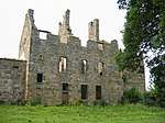 | |||
| Glenrothes, Warout Road,St Paul's Roman Catholic Church With Presbytery And Boundary Walls | 56°11′29″N 3°09′37″W | Category A | 10012 | | |||
| Coaltown Of Balgonie, Main Street, Victoria Hall With Boundary Wall, Gates And Railings | 56°11′06″N 3°07′30″W | Category C(S) | 42976 | | |||
| Coaltown Of Balgonie, School Street, Primary School With Outbuilding | 56°11′10″N 3°07′41″W | Category C(S) | 42977 | | |||
| Balbirnie Estate, Kirkforthar Farmhouse With Boundary Walls | 56°13′54″N 3°07′38″W | Category C(S) | 42984 | | |||
| Milton Of Balgonie, 54 Main Street, Milton House With Gatepiers And Boundary Walls | 56°11′37″N 3°05′45″W | Category C(S) | 42990 | | |||
| Thornton, 17 Main Street | 56°09′52″N 3°08′44″W | Category C(S) | 42993 | | |||
| Windygates, Milton Road, The Auld Hoose With Boundary Walls, Gatepiers And Gates And Wrought-Iron Sign | 56°11′34″N 3°03′23″W | Category C(S) | 43014 | | |||
| Betson Street, Primary School With Boundary Walls, Gatepiers, Gates And Railings | 56°12′05″N 3°08′07″W | Category B | 42941 | | |||
| Haig Business Park, Bonded Warehouse | 56°11′58″N 3°07′56″W | Category B | 42945 | | |||
| Northall Road, Brunton Bridge | 56°12′23″N 3°07′49″W | Category C(S) | 42954 | | |||
| Alburne Park, Levenbank With Outbuilding, Gate, Gatepiers And Boundary Wallsalburne Park, Levenbank With Outbuilding, Gate, Gatepiers And Boundary Walls | 56°11′56″N 3°09′02″W | Category B | 42957 | | |||
| 45 Commercial Street, Hunterville With Boundary Walls And Railings | 56°12′21″N 3°08′06″W | Category C(S) | 37662 | | |||
| 27 High Street With Railings | 56°12′09″N 3°07′56″W | Category C(S) | 37672 | | |||
| Windygates, Cameron Hospital, Lodge House With Gatepiers | 56°11′09″N 3°03′16″W | Category C(S) | 43383 | | |||
| Coaltown Of Balgonie, 90 Main Street With Boundary Wall, Gates And Railings | 56°11′02″N 3°07′50″W | Category B | 42974 | | |||
| Thornton, Beam-Engine House | 56°09′46″N 3°08′30″W | Category A | 42992 | | |||
| Windygates, Balcurvie Road, Church Of Scotland Church With Boundary Walls, Gatepiers And Railings | 56°11′36″N 3°03′23″W | Category C(S) | 43007 | | |||
| Kirk Street, Church Hall | 56°12′19″N 3°08′05″W | Category C(S) | 42952 | | |||
| Balbirnie Park, Balbirnie Burn Bridge | 56°12′42″N 3°09′05″W | Category C(S) | 42960 | | |||
| Balbirnie Park, Lodge At Stob Cross With Gatepier And Boundary Walls | 56°12′27″N 3°08′11″W | Category C(S) | 42963 | | |||
| Balgonie Policies, Gardener's Cottage With Outbuilding And Boundary Walls | 56°11′38″N 3°06′45″W | Category C(S) | 42967 | | |||
| Kirk Brae, St Drostan's Parish Church Graveyard With Boundary Walls Gates And Railings | 56°12′18″N 3°08′02″W | Category B | 37645 | | |||
| Kirk Wynd, Mansefield With Outbuilding And Boundary Wall | 56°12′21″N 3°08′00″W | Category B | 37655 | | |||
| 33 Commercial Street | 56°12′19″N 3°08′08″W | Category C(S) | 37660 | | |||
| 42 Commercial Street With Boundary Walls | 56°12′19″N 3°08′07″W | Category C(S) | 37666 | | |||
| Bandon Tower | 56°13′31″N 3°10′05″W | Category B | 16681 | | |||
| Windygates, Cameron Bridge | 56°11′18″N 3°03′12″W | Category B | 16683 | | |||
| Balbirnie Railway Viaduct | 56°11′53″N 3°08′45″W | Category B | 16686 | |
Key
The scheme for classifying buildings in Scotland is:
- Category A: "buildings of national or international importance, either architectural or historic; or fine, little-altered examples of some particular period, style or building type."[1]
- Category B: "buildings of regional or more than local importance; or major examples of some particular period, style or building type, which may have been altered."[1]
- Category C: "buildings of local importance; lesser examples of any period, style, or building type, as originally constructed or moderately altered; and simple traditional buildings which group well with other listed buildings."[1]
In March 2016 there were 47,288 listed buildings in Scotland. Of these, 8% were Category A, and 50% were Category B, with the remaining 42% being Category C.[2]
gollark: * LOL out loud
gollark: Hmm, that sounds useful.
gollark: It would really have made more sense for them to design the whole thing in a sane way in the first place.
gollark: ... sure?
gollark: Really? Neat.
See also
Notes
- Sometimes known as OSGB36, the grid reference (where provided) is based on the British national grid reference system used by the Ordnance Survey.
• "Guide to National Grid". Ordnance Survey. Retrieved 2007-12-12.
• "Get-a-map". Ordnance Survey. Retrieved 2007-12-17. - Historic Environment Scotland assign a unique alphanumeric identifier to each designated site in Scotland, for listed buildings this always begins with "LB", for example "LB12345".
References
- All entries, addresses and coordinates are based on data from Historic Scotland. This data falls under the Open Government Licence
- "What is Listing?". Historic Environment Scotland. Retrieved 29 May 2018.
- Scotland's Historic Environment Audit 2016 (PDF). Historic Environment Scotland and the Built Environment Forum Scotland. pp. 15–16. Retrieved 29 May 2018.
This article is issued from Wikipedia. The text is licensed under Creative Commons - Attribution - Sharealike. Additional terms may apply for the media files.