List of listed buildings in Lundie, Angus
List
| Name | Location | Date Listed | Grid Ref. [note 1] | Geo-coordinates | Notes | LB Number [note 2] | Image |
|---|---|---|---|---|---|---|---|
| Lundie Castle Including Enclosing Walls And Gatepiers And Garden House | 56°30′42″N 3°07′26″W | Category C(S) | 13082 |  | |||
| Lundie Mill House/Kirklands | 56°30′58″N 3°09′14″W | Category B | 13084 | | |||
| Lundie Mill And Steading | 56°30′55″N 3°09′03″W | Category B | 13636 | | |||
| Neuk Farmhouse | 56°31′58″N 3°07′42″W | Category C(S) | 13088 | | |||
| Parish Church, Including Duncan Burial Enclosure, Churchyard Wall And Gatepiers | 56°30′58″N 3°09′16″W | Category A | 13090 | 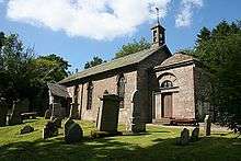 | |||
| Clushmill Mill House, Including Stables | 56°31′17″N 3°08′15″W | Category C(S) | 13080 | | |||
| The Roundie, Village Pump | 56°30′58″N 3°09′13″W | Category B | 13087 | | |||
| Wester Keith, Cartshed And Granary | 56°31′43″N 3°09′31″W | Category B | 13091 | | |||
| Lundie Village, K6 Telephone Kiosk Close To The Church | 56°30′57″N 3°09′13″W | Category B | 13085 | | |||
| Ardgarth Cottage | 56°31′15″N 3°09′48″W | Category C(S) | 13079 | | |||
| Former School Including Boundary Wall | 56°30′57″N 3°09′07″W | Category B | 13081 | | |||
| Lundie Castle Farm, Farmhouse | 56°30′29″N 3°07′20″W | Category C(S) | 13083 | | |||
| Lundie Village, Pump Near Village Hall | 56°31′00″N 3°09′21″W | Category B | 13086 | | |||
| Old Manse, Garden Wall And Pump, Coach House/Stable | 56°30′53″N 3°09′17″W | Category C(S) | 13089 | |
Key
The scheme for classifying buildings in Scotland is:
- Category A: "buildings of national or international importance, either architectural or historic; or fine, little-altered examples of some particular period, style or building type."[1]
- Category B: "buildings of regional or more than local importance; or major examples of some particular period, style or building type, which may have been altered."[1]
- Category C: "buildings of local importance; lesser examples of any period, style, or building type, as originally constructed or moderately altered; and simple traditional buildings which group well with other listed buildings."[1]
In March 2016 there were 47,288 listed buildings in Scotland. Of these, 8% were Category A, and 50% were Category B, with the remaining 42% being Category C.[2]
gollark: Realerer users use a *true* command line, with no "colors" or "TUI programs".
gollark: It already has a window manager.
gollark: solarflame5
gollark: I do not know them all by number.
gollark: I filled it all in and expanded the claim, but it's... odd.
See also
Notes
- Sometimes known as OSGB36, the grid reference (where provided) is based on the British national grid reference system used by the Ordnance Survey.
• "Guide to National Grid". Ordnance Survey. Retrieved 2007-12-12.
• "Get-a-map". Ordnance Survey. Retrieved 2007-12-17. - Historic Environment Scotland assign a unique alphanumeric identifier to each designated site in Scotland, for listed buildings this always begins with "LB", for example "LB12345".
References
- All entries, addresses and coordinates are based on data from Historic Scotland. This data falls under the Open Government Licence
- "What is Listing?". Historic Environment Scotland. Retrieved 29 May 2018.
- Scotland's Historic Environment Audit 2016 (PDF). Historic Environment Scotland and the Built Environment Forum Scotland. pp. 15–16. Retrieved 29 May 2018.
This article is issued from Wikipedia. The text is licensed under Creative Commons - Attribution - Sharealike. Additional terms may apply for the media files.