List of listed buildings in Lonmay, Aberdeenshire
List
| Name | Location | Date Listed | Grid Ref. [note 1] | Geo-coordinates | Notes | LB Number [note 2] | Image |
|---|---|---|---|---|---|---|---|
| Crimonmogate House Sundial | 57°37′05″N 1°56′05″W | Category B | 13718 |  | |||
| Crimonmogate House Game Larder | 57°37′07″N 1°56′06″W | Category C(S) | 9240 | | |||
| Bridge Over Burn Of Logie At S.E. Lodge | 57°36′58″N 1°55′52″W | Category C(S) | 9253 | | |||
| Logie Lodges | 57°36′30″N 1°56′16″W | Category B | 9255 | | |||
| Kininmonth Church | 57°33′50″N 1°59′05″W | Category C(S) | 9260 | | |||
| Craigellie House Walled Garden And Old House Of Craigellie | 57°37′58″N 1°57′41″W | Category C(S) | 9268 | | |||
| Crimonmogate House | 57°37′06″N 1°56′05″W | Category A | 9270 | 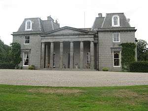 | |||
| Lonmay, St Columba's Including Lychgate | 57°37′49″N 1°56′25″W | Category C(S) | 49840 | | |||
| Lumbs Farmhouse | 57°36′31″N 1°57′11″W | Category B | 9257 | | |||
| Cairness House | 57°38′17″N 1°56′15″W | Category A | 9263 | | |||
| Cairness House Walled Garden | 57°38′06″N 1°56′12″W | Category C(S) | 9265 | | |||
| Pavillions (Old Lonmay House) | 57°38′16″N 1°55′28″W | Category C(S) | 13717 | | |||
| Crimonmogate House Monument | 57°37′06″N 1°55′54″W | Category B | 9241 | 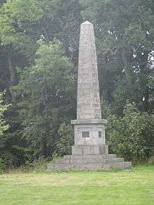 | |||
| Crimonmogate House Kennels House | 57°36′57″N 1°56′39″W | Category C(S) | 9251 | | |||
| Crimonmogate House S.E. Lodge Near Mill Of Crimonmogate | 57°36′57″N 1°55′54″W | Category B | 9252 | | |||
| Cairness, Home Farm, Formerly Barnyards Of Cairness | 57°38′28″N 1°56′14″W | Category C(S) | 9266 | | |||
| Craigellie House, West Lodge | 57°38′00″N 1°58′18″W | Category C(S) | 9269 | | |||
| Crimonmogate House Stableblock | 57°37′06″N 1°56′13″W | Category B | 9242 | | |||
| Crimonmogate House Old Laundry | 57°37′05″N 1°56′15″W | Category C(S) | 9244 | | |||
| Crimonmogate House North Lodge | 57°37′13″N 1°56′37″W | Category C(S) | 9247 | | |||
| Mill Of Crimonmogate, Former Mill | 57°36′55″N 1°55′56″W | Category C(S) | 9254 | | |||
| Windpump, Savock | 57°37′02″N 1°54′27″W | Category B | 9258 | | |||
| Cairness House, South Lodges, Gates And Railings | 57°37′50″N 1°56′24″W | Category A | 9264 | | |||
| Crimonmogate House Garden Wall And Outhouses S. Of Stableblock | 57°37′05″N 1°56′11″W | Category C(S) | 9245 | | |||
| Crimonmogate House Dovecot | 57°37′06″N 1°56′23″W | Category B | 9246 | | |||
| Crimonmogate House Main (West) Gate And Gardener's Lodge | 57°37′03″N 1°56′52″W | Category B | 9248 | | |||
| Kininmonth House | 57°34′02″N 1°56′48″W | Category C(S) | 9259 | | |||
| Craigellie House | 57°37′55″N 1°57′41″W | Category C(S) | 9267 | | |||
| Mill Of Crimonmogate Farmhouse | 57°36′54″N 1°55′57″W | Category C(S) | 6738 | | |||
| Crimonmogate House Kennels | 57°36′57″N 1°56′40″W | Category C(S) | 9250 | | |||
| Parish Church Of Lonmay | 57°37′54″N 1°56′15″W | Category B | 9261 | | |||
| Churchyard Of Lonmay | 57°38′01″N 1°56′10″W | Category B | 9262 | | |||
| Crimonmogate House Dairy | 57°37′08″N 1°56′15″W | Category B | 9243 | | |||
| Crimonmogate House Walled Garden | 57°37′00″N 1°56′54″W | Category C(S) | 9249 | | |||
| Logie, Old Coachhouse | 57°19′20″N 2°29′24″W | Category B | 9256 | |
Key
The scheme for classifying buildings in Scotland is:
- Category A: "buildings of national or international importance, either architectural or historic; or fine, little-altered examples of some particular period, style or building type."[1]
- Category B: "buildings of regional or more than local importance; or major examples of some particular period, style or building type, which may have been altered."[1]
- Category C: "buildings of local importance; lesser examples of any period, style, or building type, as originally constructed or moderately altered; and simple traditional buildings which group well with other listed buildings."[1]
In March 2016 there were 47,288 listed buildings in Scotland. Of these, 8% were Category A, and 50% were Category B, with the remaining 42% being Category C.[2]
gollark: Incorrect. We're using cutting-edge procedural dynamical legal generation techniques.
gollark: (clause 4.4)
gollark: Mine invoke the potatOS privacy policy to utterly invalidate this.
gollark: You can *try* this, but my generated legal systems will of course forbid transferring to yours.
gollark: Initiating procedural legal system generation at 171THz.
Notes
- Sometimes known as OSGB36, the grid reference (where provided) is based on the British national grid reference system used by the Ordnance Survey.
• "Guide to National Grid". Ordnance Survey. Retrieved 2007-12-12.
• "Get-a-map". Ordnance Survey. Retrieved 2007-12-17. - Historic Environment Scotland assign a unique alphanumeric identifier to each designated site in Scotland, for listed buildings this always begins with "LB", for example "LB12345".
References
- All entries, addresses and coordinates are based on data from Historic Scotland. This data falls under the Open Government Licence
- "What is Listing?". Historic Environment Scotland. Retrieved 29 May 2018.
- Scotland's Historic Environment Audit 2016 (PDF). Historic Environment Scotland and the Built Environment Forum Scotland. pp. 15–16. Retrieved 29 May 2018.
This article is issued from Wikipedia. The text is licensed under Creative Commons - Attribution - Sharealike. Additional terms may apply for the media files.