List of listed buildings in Lintrathen, Angus
List
| Name | Location | Date Listed | Grid Ref. [note 1] | Geo-coordinates | Notes | LB Number [note 2] | Image |
|---|---|---|---|---|---|---|---|
| West Lodge - Gates | 56°40′21″N 3°11′47″W | Category C(S) | 11438 | 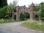 | |||
| Fornethy Residential School | 56°41′11″N 3°13′54″W | Category C(S) | 11439 |  | |||
| Dykend Bridge Over Back Water | 56°42′15″N 3°13′29″W | Category B | 11441 | | |||
| Lintrathen Parish Kirk | 56°40′39″N 3°10′04″W | Category C(S) | 11431 | | |||
| Parish Kirk Manse Now Melgam House | 56°40′39″N 3°10′09″W | Category C(S) | 11434 | | |||
| Lintrathen Bridge Over Melgam Water | 56°40′39″N 3°10′17″W | Category C(S) | 11435 | 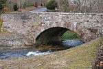 | |||
| Balintore - Burnside Lodge | 56°42′50″N 3°09′06″W | Category C(S) | 11442 | | |||
| Bridge Of Lintrathen, Fingerpost | 56°40′38″N 3°10′18″W | Category C(S) | 51611 | 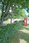 | |||
| Balintore Castle | 56°43′03″N 3°09′40″W | Category A | 13757 | 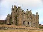 | |||
| Kirkton Of Lintrathen - Old Cornmill | 56°40′38″N 3°10′16″W | Category C(S) | 11437 | | |||
| Lintrathen Reservoir, Main Lodge Including Stable Courtyard And Archway, Entrance Gatepiers And Gates | 56°40′22″N 3°11′16″W | Category B | 48618 | | |||
| Parish Kirkyard Walls And Tombstones | 56°40′39″N 3°10′03″W | Category C(S) | 11432 | | |||
| Foldend Forester's House | 56°41′15″N 3°09′48″W | Category C(S) | 11440 | | |||
| Parish Kirkyard - Hearse House | 56°40′39″N 3°10′05″W | Category C(S) | 11433 | | |||
| Kirkton Of Lintrathen - "Craigie Linn Cottage" | 56°40′39″N 3°10′15″W | Category C(S) | 11436 | | |||
| Lintrathen Water Board - West Lodge | 56°40′22″N 3°11′48″W | Category C(S) | 13756 | | |||
| Balintore Castle, Kennels | 56°43′05″N 3°09′44″W | Category C(S) | 12969 | |
Key
The scheme for classifying buildings in Scotland is:
- Category A: "buildings of national or international importance, either architectural or historic; or fine, little-altered examples of some particular period, style or building type."[1]
- Category B: "buildings of regional or more than local importance; or major examples of some particular period, style or building type, which may have been altered."[1]
- Category C: "buildings of local importance; lesser examples of any period, style, or building type, as originally constructed or moderately altered; and simple traditional buildings which group well with other listed buildings."[1]
In March 2016 there were 47,288 listed buildings in Scotland. Of these, 8% were Category A, and 50% were Category B, with the remaining 42% being Category C.[2]
gollark: Sounds 9006% non-bad to me!
gollark: What *could* go wrong?
gollark: What if you could only worldedit a useless random unclaimed patch of land into either air or dirt?
gollark: Free time here too. Still boring though.
gollark: The server is quite boring now.
See also
Notes
- Sometimes known as OSGB36, the grid reference (where provided) is based on the British national grid reference system used by the Ordnance Survey.
• "Guide to National Grid". Ordnance Survey. Retrieved 2007-12-12.
• "Get-a-map". Ordnance Survey. Retrieved 2007-12-17. - Historic Environment Scotland assign a unique alphanumeric identifier to each designated site in Scotland, for listed buildings this always begins with "LB", for example "LB12345".
References
- All entries, addresses and coordinates are based on data from Historic Scotland. This data falls under the Open Government Licence
- "What is Listing?". Historic Environment Scotland. Retrieved 29 May 2018.
- Scotland's Historic Environment Audit 2016 (PDF). Historic Environment Scotland and the Built Environment Forum Scotland. pp. 15–16. Retrieved 29 May 2018.
This article is issued from Wikipedia. The text is licensed under Creative Commons - Attribution - Sharealike. Additional terms may apply for the media files.