List of listed buildings in Leuchars, Fife
List
| Name | Location | Date Listed | Grid Ref. [note 1] | Geo-coordinates | Notes | LB Number [note 2] | Image |
|---|---|---|---|---|---|---|---|
| Parish Kirkyard | 56°22′53″N 2°53′00″W | Category B | 8843 |  | |||
| 2 Main Street 'Rachel's Inn' | 56°22′53″N 2°52′56″W | Category C(S) | 8847 | | |||
| Schoolbrae | 56°22′54″N 2°53′08″W | Category C(S) | 8849 | | |||
| Mileplate At Balmullo Farm | 56°22′30″N 2°55′41″W | Category B | 8855 | | |||
| Clayton House (Now Flatted) | 56°21′14″N 2°55′23″W | Category C(S) | 8859 | | |||
| Kinshaldy House, Farmsteading And Walled Garden | 56°24′06″N 2°49′52″W | Category B | 8865 | | |||
| Strathburn Farmhouse | 56°24′00″N 2°55′31″W | Category B | 8896 | | |||
| Mileplate At Pickletillem | 56°24′38″N 2°54′52″W | Category B | 8897 | | |||
| Guardbridge, Seggie House Including Gate Lodge And Walled Garden | 56°21′36″N 2°54′02″W | Category C(S) | 50494 | | |||
| Guardbridge, Paper Mill (Former), Boiler House (Mill Building 49) And Stalk | 56°21′56″N 2°53′24″W | Category B | 51397 | | |||
| Raf Leuchars, Domestic Side, Officers' Mess, Building Nos 10, 11, 65 And 175 | 56°22′38″N 2°53′08″W | Category C(S) | 51420 | | |||
| Raf Leuchars, Domestic Side, Former Barracks Blocks, Buildings 25, 26 And 27 | 56°22′42″N 2°53′01″W | Category B | 51418 | | |||
| Mileplate 300 Yards North Of Muirhead | 56°21′44″N 2°56′22″W | Category B | 13699 | | |||
| Earlshall Walled Garden | 56°22′44″N 2°52′04″W | Category B | 8805 | 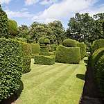 | |||
| Parish Kirk Manse | 56°22′55″N 2°52′55″W | Category B | 8844 | | |||
| 3, 5, 7 Pitlethie Road ('Briar Cottage', 'The Anchorage' And 'Rose Cottage') | 56°22′59″N 2°53′00″W | Category C(S) | 8845 | | |||
| 7 Main Street 'Wayside' | 56°22′53″N 2°52′58″W | Category C(S) | 8848 | | |||
| Doocot, Leuchars Castle | 56°23′11″N 2°53′20″W | Category A | 8851 | 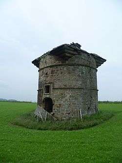 | |||
| Earlshall | 56°22′44″N 2°52′06″W | Category A | 8852 | 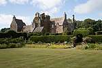 | |||
| Guardbridge (Old) Over River Eden | 56°21′33″N 2°53′19″W | Category A | 8861 | | |||
| Raf Leuchars, Domestic Side, Barracks Blocks, Buildings 1, 2, 3 And 5 | 56°22′42″N 2°52′57″W | Category C(S) | 51417 | | |||
| Vicarsford Cemetery, Lodge, Boundary Walls, Gates, Gatepiers And Railings | 56°25′16″N 2°54′47″W | Category B | 13476 | | |||
| Balmullo Farmhouse And Gatepiers | 56°22′29″N 2°55′45″W | Category B | 8893 | | |||
| Earlshall, Sundial To West Of House | 56°22′44″N 2°52′07″W | Category C(S) | 13014 | | |||
| The Cottage (Now Willowbank) Guardbridge | 56°21′35″N 2°53′31″W | Category B | 8860 | | |||
| Vicarsford Cemetery Chapel | 56°25′13″N 2°54′41″W | Category A | 8863 | | |||
| Guideplates At Junction Of A92 And Wormit Road 700 Yards North Of St Michael's | 56°23′56″N 2°54′40″W | Category B | 8898 | | |||
| Guardbridge, Paper Mill (Former), Main Street Buildings Numbers 1, 2, 3, 3A, 4, 6, 7, 8, 17 And 26 | 56°21′54″N 2°53′32″W | Category B | 51396 | | |||
| Raf Leuchars, Domestic Side, Former Squash Court, Building No 70 | 56°22′41″N 2°53′03″W | Category C(S) | 51419 | | |||
| Raf Leuchars, Technical Side, Former Operations Block, Building 181 | 56°22′43″N 2°52′48″W | Category C(S) | 51422 | | |||
| Craigie House | 56°24′25″N 2°53′13″W | Category B | 8808 | | |||
| Parish Kirk Of St Athernase | 56°22′54″N 2°53′00″W | Category A | 8842 | | |||
| Mileplates At Junction Of A91 And A92 North-East Of Dairsie Village | 56°20′53″N 2°56′33″W | Category B | 8856 | | |||
| Raf Leuchars, Domestic Side, Old Sergeants' Mess, Building 8 | 56°22′45″N 2°52′55″W | Category C(S) | 51421 | | |||
| Leuchars War Memorial | 56°23′05″N 2°53′56″W | Category C(S) | 10798 | | |||
| 86 Main Street, 'st Annes' | 56°23′02″N 2°53′21″W | Category B | 8850 | | |||
| Pitcullo Castle | 56°21′44″N 2°57′03″W | Category A | 8857 | 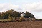 | |||
| Raf Leuchars, Technical Side, General Service Aircraft Sheds, Buildings 55 And 57 | 56°22′35″N 2°52′33″W | Category A | 51423 | | |||
| Craigsanquhar House | 56°21′40″N 2°58′50″W | Category B | 43925 | | |||
| Craigsanquhar House, Steading | 56°21′41″N 2°58′53″W | Category C(S) | 43926 | | |||
| Leuchars Lodge, Hermitage Lodge | 56°23′43″N 2°54′18″W | Category C(S) | 13723 | | |||
| Earlshall, Sundial On East Side Of Terraced Garden | 56°22′44″N 2°52′02″W | Category B | 13015 | | |||
| Pitlethie House | 56°23′11″N 2°52′42″W | Category B | 8807 | | |||
| Mileplate Near Southfield | 56°23′11″N 2°54′57″W | Category B | 8854 | | |||
| Clayton Den Ice House Above Moonzie Burn | 56°21′28″N 2°55′51″W | Category C(S) | 8864 | | |||
| 59 And 61 Main Street, Ye Olde Hotel Including Gig House With Hayloft And Boundary Wall | 56°22′57″N 2°53′15″W | Category B | 49915 | | |||
| Craigsanquhar House, Walled Garden | 56°21′43″N 2°58′47″W | Category B | 43927 | | |||
| Earlshall Lodge | 56°22′46″N 2°52′08″W | Category B | 8806 | | |||
| 9 Pitlethie Road 'seaview' | 56°22′56″N 2°52′59″W | Category C(S) | 8846 | | |||
| Earlshall Doocot | 56°22′42″N 2°52′07″W | Category A | 8853 | .jpg) | |||
| Pitcullo Doocot | 56°21′39″N 2°57′00″W | Category B | 8858 | | |||
| Inner Bridge (Old) Over Motray Water, Guardbridge | 56°22′01″N 2°53′31″W | Category B | 8862 | | |||
| Balmullo Steading | 56°22′30″N 2°55′43″W | Category C(S) | 8894 | | |||
| Hayston Farmhouse | 56°22′08″N 2°56′26″W | Category B | 8895 | | |||
| Mileplate Approx 500 Yards North Of St Michael's | 56°23′51″N 2°54′34″W | Category B | 8899 | | |||
| Raf Leuchars, Technical Side, Watch Office, Building 213 | 56°22′31″N 2°52′49″W | Category C(S) | 51424 | |
Key
The scheme for classifying buildings in Scotland is:
- Category A: "buildings of national or international importance, either architectural or historic; or fine, little-altered examples of some particular period, style or building type."[1]
- Category B: "buildings of regional or more than local importance; or major examples of some particular period, style or building type, which may have been altered."[1]
- Category C: "buildings of local importance; lesser examples of any period, style, or building type, as originally constructed or moderately altered; and simple traditional buildings which group well with other listed buildings."[1]
In March 2016 there were 47,288 listed buildings in Scotland. Of these, 8% were Category A, and 50% were Category B, with the remaining 42% being Category C.[2]
gollark: ```File Formats csv — CSV File Reading and Writing configparser — Configuration file parser netrc — netrc file processing xdrlib — Encode and decode XDR data plistlib — Generate and parse Mac OS X .plist files```More random stuff which probably nobody ever needs.
gollark: ```Data Compression and Archiving zlib — Compression compatible with gzip gzip — Support for gzip files```(not whole section)
gollark: Two different things for globby pattern matching, stupid amounts of different things for paths.
gollark: ```File and Directory Access pathlib — Object-oriented filesystem paths os.path — Common pathname manipulations fileinput — Iterate over lines from multiple input streams stat — Interpreting stat() results filecmp — File and Directory Comparisons tempfile — Generate temporary files and directories glob — Unix style pathname pattern expansion fnmatch — Unix filename pattern matching linecache — Random access to text lines shutil — High-level file operations macpath — Mac OS 9 path manipulation functions```The standard library being weird.
gollark: We have `let`/`const` now.
See also
Notes
- Sometimes known as OSGB36, the grid reference (where provided) is based on the British national grid reference system used by the Ordnance Survey.
• "Guide to National Grid". Ordnance Survey. Retrieved 12 December 2007.
• "Get-a-map". Ordnance Survey. Retrieved 17 December 2007. - Historic Environment Scotland assign a unique alphanumeric identifier to each designated site in Scotland, for listed buildings this always begins with "LB", for example "LB12345".
References
- All entries, addresses and coordinates are based on data from Historic Scotland. This data falls under the Open Government Licence
- "What is Listing?". Historic Environment Scotland. Retrieved 29 May 2018.
- Scotland's Historic Environment Audit 2016 (PDF). Historic Environment Scotland and the Built Environment Forum Scotland. pp. 15–16. Retrieved 29 May 2018.
This article is issued from Wikipedia. The text is licensed under Creative Commons - Attribution - Sharealike. Additional terms may apply for the media files.