List of listed buildings in Lasswade, Midlothian
List
| Name | Location | Date Listed | Grid Ref. [note 1] | Geo-coordinates | Notes | LB Number [note 2] | Image |
|---|---|---|---|---|---|---|---|
| Lasswade, Dunesk House, Lodge, Gatepiers, Gates And Boundary Walls | 55°52′53″N 3°07′22″W | Category C(S) | 44154 |  | |||
| Lasswade, Dunesk House, Walled Garden | 55°52′54″N 3°07′18″W | Category C(S) | 44155 | | |||
| Midfield Lodge, Polton, Including Gatepiers, Boundary Wall And Railings | 55°51′50″N 3°08′04″W | Category C(S) | 44167 | | |||
| Rosewell, 1 Carnethie Street, (Formerly The Manse) Including Boundary Walls | 55°51′24″N 3°07′50″W | Category C(S) | 44169 | | |||
| Rosewell, 295 Carnethie Street, Rosedale House | 55°50′38″N 3°08′28″W | Category C(S) | 44171 | | |||
| Rosewell, Carnethie Street, St Matthew Rc Church Including Presbytery, Boundary Walls, Gateway And Cloisters | 55°51′19″N 3°08′06″W | Category B | 13024 | 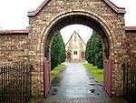 | |||
| Rosslyn Castle, Including Bridge | 55°51′09″N 3°09′36″W | Category A | 13026 | 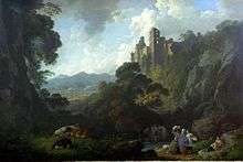 | |||
| Rosslyn, Collegehill House, Formerly The Old Inn, Including Boundary Walls And Gateway | 55°51′20″N 3°09′38″W | Category B | 13029 | | |||
| Melville Castle, East Lodge Including Gatepiers And Quadrant Walls | 55°53′40″N 3°05′31″W | Category B | 12934 | | |||
| Melville Castle, Garden Cottage | 55°53′31″N 3°06′48″W | Category C(S) | 12935 | | |||
| Elginhaugh Farmhouse And Cottages | 55°53′31″N 3°05′26″W | Category B | 12941 | | |||
| Lasswade, Wadingburn Road, Barony House (Formerly Lasswade Cottage) | 55°52′52″N 3°07′31″W | Category A | 7398 | | |||
| Lasswade, Melville Dykes Road, Pittendreich House, South Lodge, Including Boundary Walls | 55°53′05″N 3°06′20″W | Category B | 44160 | 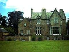 | |||
| Lasswade, Wadingburn Lane, Carlethan House | 55°52′57″N 3°07′39″W | Category C(S) | 44161 | | |||
| Rosewell, Carnethie Street, St Joseph's Hospital Lodge, Gatepiers And Railings | 55°51′21″N 3°07′55″W | Category B | 44170 | | |||
| Roslin, Main Street, The Original Rosslyn Hotel | 55°51′25″N 3°09′50″W | Category C(S) | 44175 | 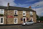 | |||
| Hawthornden Castle, Lodge | 55°51′38″N 3°08′10″W | Category C(S) | 44142 | | |||
| Rosewell, Carnethie Street, Rosewell Institute, Including Boundary Wall, Railings And Gates | 55°50′59″N 3°08′14″W | Category B | 43642 | | |||
| Hawthornden Castle, Including Gatepiers, Boundary Walls, Wellhead Drinking Fountainhead And Outbuilding | 55°51′39″N 3°08′29″W | Category A | 13023 | | |||
| Roslin, Rosebank Cottage (Formerly Stables) And Boundary Wall | 55°51′24″N 3°09′21″W | Category B | 13027 | | |||
| Auchindinny, Firth House | 55°50′25″N 3°11′19″W | Category B | 13033 | | |||
| Melville Castle, Esk Cottage With Sawmill And Cottage | 55°53′21″N 3°06′34″W | Category B | 12937 | | |||
| Meville Castle, Walled Garden Steading | 55°53′28″N 3°06′33″W | Category C(S) | 12938 | | |||
| Lasswade, Melville Dykes Road, Pittendreich House, Doocot | 55°53′05″N 3°06′28″W | Category B | 7392 | | |||
| Melville Castle, Chestnut House, (Formerly Coach House And Stables) | 55°53′25″N 3°06′22″W | Category B | 7397 | | |||
| Lasswade, 11 Kevock Road, Mount Esk, Including Former Stables Gatepiers, Gates And Boundary Walls | 55°52′43″N 3°07′32″W | Category B | 7403 | | |||
| Mavisbank House, (Formerly New Saughtonhall), Including Service Wing, Terraces, Retaining Walls, And Steps | 55°52′27″N 3°08′22″W | Category A | 7404 | 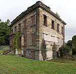 | |||
| Lasswade Cemetery; Lodges, Gatepiers, Gates And Boundary Walls | 55°52′58″N 3°07′06″W | Category B | 44144 | 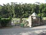 | |||
| Mavisbank House, Game Larder | 55°52′25″N 3°08′21″W | Category B | 44164 | | |||
| Mavisbank House, Walled Gardens, Including Gates And Gatepiers | 55°52′25″N 3°08′14″W | Category A | 44166 | | |||
| Polton Road, Montrose Farm Steading (Now Stables) And Cottages | 55°51′54″N 3°08′02″W | Category C(S) | 13021 | | |||
| Bilston Railway Viaduct Over Bilston Burn | 55°52′17″N 3°09′04″W | Category A | 13035 | 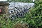 | |||
| Mavisbank House, Gazebo | 55°52′20″N 3°08′18″W | Category A | 7387 | | |||
| 6 Polton Bank, De Quincey Cottage , Including Gates, Gatepiers, Boundary Walls, Railings, And Garden Walls | 55°52′16″N 3°08′05″W | Category B | 7388 | | |||
| Lasswade, Esk Tower, Including Gatepiers, Gates And Boundary Walls | 55°52′50″N 3°07′18″W | Category B | 7401 | | |||
| Lasswade, 20 Kevock Road, Little Crawfurd, Including Former Cart Shed, Stables And Boundary Walls | 55°52′41″N 3°07′32″W | Category C(S) | 44158 | | |||
| Polton Bank, Priorwood House, Formerly Mavisbush House, Including Gates, Gatepiers And Boundary Walls | 55°52′15″N 3°08′10″W | Category B | 44168 | | |||
| Rosewell, 150 Carnethie Street, Rosewell Mains With Ancillary Structures | 55°51′02″N 3°08′17″W | Category B | 44173 | | |||
| Roslin, 29 Manse Road | 55°51′31″N 3°09′45″W | Category B | 44176 | | |||
| Roslin, Penicuik Road, Roslin Glen Hotel | 55°51′25″N 3°09′51″W | Category C(S) | 44177 | | |||
| Rosslyn Cemetery, Including Gates, Gatepiers And Boundary Walls | 55°51′19″N 3°09′43″W | Category C(S) | 44178 | 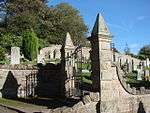 | |||
| Rosslyn, Custodian's Office (Stables To Old Inn), Including Boundary Walls And Adjoining Gateway To Rosslyn Chapel | 55°49′53″N 3°09′33″W | Category B | 13030 | | |||
| Melville Castle, Willie's Temple | 55°53′23″N 3°06′44″W | Category A | 12940 | | |||
| Lasswade Old Kirkyard, Including Boundary Walls, Burial Aisles And Enclosures | 55°52′59″N 3°07′04″W | Category B | 7390 | 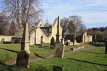 | |||
| Melville Castle | 55°53′28″N 3°06′16″W | Category A | 7394 | 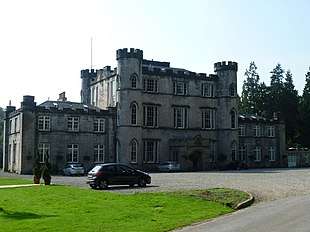 | |||
| Lasswade, Kevock Road, Kevock Tower, Summerhouse | 55°52′44″N 3°07′22″W | Category C(S) | 44159 | | |||
| Mavisbank House, Dairy (Comprising South Lodge, The Coach House And The Barn), Including Gatepiers, Gates And Walled Yard | 55°52′19″N 3°08′19″W | Category C(S) | 44163 | | |||
| Rosewell, Carnethie Street, Rosewell Parish Church, Including Gatepiers And Gates | 55°51′00″N 3°08′17″W | Category B | 44172 | 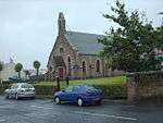 | |||
| Roslin, Eskhill House, Including Gatepiers, Terrace And Boundary Walls And Outbuilding | 55°51′00″N 3°10′37″W | Category B | 13846 | | |||
| Pentland Burial Ground, Including Watch House, Vault And Boundary Walls | 55°53′04″N 3°10′51″W | Category B | 13036 | 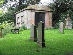 | |||
| Melville Castle, South Lodge, Including Gatepiers And Quadrant Walls | 55°53′13″N 3°06′08″W | Category C(S) | 12933 | | |||
| Melville Castle, Garden Farmhouse With Gatepiers | 55°53′31″N 3°06′46″W | Category C(S) | 12936 | | |||
| Elginhaugh Bridge, River North Esk | 55°53′32″N 3°05′12″W | Category B | 7393 | | |||
| Baird Smith Memorial | 55°53′00″N 3°07′02″W | Category C(S) | 50605 | | |||
| Hardengreen House | 55°52′47″N 3°04′54″W | Category C(S) | 45599 | | |||
| Lasswade, 16 Kevock Road, Including Boundary Wall | 55°52′44″N 3°07′38″W | Category B | 44157 | | |||
| Gorton Road, Old Gorton House | 55°51′21″N 3°08′57″W | Category C(S) | 13025 | | |||
| Melville Mains, South Range Of Steading | 55°53′27″N 3°07′05″W | Category B | 12939 | | |||
| Lasswade, Melville Dykes Road, Pittendreich House, Including Gatepiers And Boundary Walls | 55°53′04″N 3°06′31″W | Category B | 7391 | | |||
| Lasswade, Wadingburn Road Barony House, Cottage And Gateway | 55°52′53″N 3°07′33″W | Category B | 7399 | | |||
| Lasswade, Dunesk House | 55°52′55″N 3°07′14″W | Category B | 7400 | | |||
| Mavisbank House, Ice House | 55°52′29″N 3°08′22″W | Category B | 44165 | | |||
| Rosewell, Castle View, Including Gatepiers And Boundary Walls | 55°51′12″N 3°09′09″W | Category B | 44174 | | |||
| Hawthornden Cottage | 55°51′38″N 3°08′08″W | Category C(S) | 44143 | | |||
| Polton Bank, St Ann's Mount | 55°52′16″N 3°07′50″W | Category B | 13206 | | |||
| Melville Castle, Lodge At Walled Garden | 55°53′25″N 3°06′42″W | Category C(S) | 13019 | | |||
| Polton Road, Polton Summerhouse | 55°52′27″N 3°07′16″W | Category B | 13020 | | |||
| Dryden Tower | 55°52′10″N 3°10′07″W | Category B | 13032 | 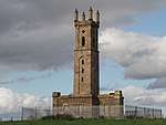 | |||
| Lasswade, 3 Kevock Road, Eskgrove, Including Boundary Walls, Gatepiers, Conservatory And Summerhouse | 55°52′49″N 3°07′32″W | Category B | 7385 | | |||
| Lasswade, Greenfield Lodge, Including Gatepiers, Gates And Outbuilding | 55°52′44″N 3°07′23″W | Category C(S) | 7402 | | |||
| Roslin Curling Pond, Building | 55°51′29″N 3°10′59″W | Category C(S) | 49691 | | |||
| Rosslynlee Hospital, Including Gate Lodge, Gatepiers, Railings And Staff Cottages | 55°50′08″N 3°10′26″W | Category C(S) | 44926 | | |||
| Lasswade, 12 Kevock Road, The Old Lodge, Including Gatepiers, Gates And Boundary Walls | 55°52′47″N 3°07′38″W | Category C(S) | 44156 | | |||
| Lasswade, Wadingburn Lane, Fettes Mount Including Conservatory, Gatepiers And Boundary Walls | 55°52′56″N 3°07′36″W | Category B | 44162 | | |||
| Lasswade Viaduct | 55°52′46″N 3°07′10″W | Category B | 13621 | | |||
| Melville Castle, Walled Garden | 55°53′29″N 3°06′40″W | Category B | 13509 | | |||
| Midfield House, Lasswade, Including Boundary Wall To Garden | 55°51′51″N 3°07′56″W | Category B | 13022 | | |||
| Rosslyn Chapel (Episcopal), Formerly Collegiate Church Of St Matthew, Including Vaults, Burial Ground And Boundary Walls | 55°51′19″N 3°09′36″W | Category A | 13028 | 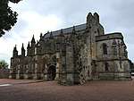 | |||
| Auchindinny House, Including Gatepiers, Boundary Walls And Outbuildings | 55°50′22″N 3°11′47″W | Category A | 13034 | | |||
| Mavisbank House, Doocot | 55°52′47″N 3°07′49″W | Category A | 7386 | .jpg) | |||
| Melville Castle, South Driveway Bridge | 55°53′19″N 3°06′30″W | Category B | 7396 | |
Key
The scheme for classifying buildings in Scotland is:
- Category A: "buildings of national or international importance, either architectural or historic; or fine, little-altered examples of some particular period, style or building type."[1]
- Category B: "buildings of regional or more than local importance; or major examples of some particular period, style or building type, which may have been altered."[1]
- Category C: "buildings of local importance; lesser examples of any period, style, or building type, as originally constructed or moderately altered; and simple traditional buildings which group well with other listed buildings."[1]
In March 2016 there were 47,288 listed buildings in Scotland. Of these, 8% were Category A, and 50% were Category B, with the remaining 42% being Category C.[2]
gollark: My meme library actually has a lot of alignment memes.
gollark: I actually have a bunch of random text processing scripts like d͓̂ͤǐ̋͐à̗ͥc͎͉̉r̺̪̎ị̍̅ţ͐ͪi̺̇̊c̼̓ͣi͌ͩ̊z̨̨͟eͨ̄̉ and zwsify.
gollark: ```python#!/usr/bin/env python3import fileinputimport sysdef process_char(c): if c == "\n" or c == " ": return c return "||" + c + "||"for line in fileinput.input(): out = "".join([process_char(c) for c in line]) sys.stdout.buffer.write(out.encode("utf-8"))```
gollark: I made a simple python script for it.
gollark: https://github.com/acelewis/my_first_calculator.py
Notes
- Sometimes known as OSGB36, the grid reference (where provided) is based on the British national grid reference system used by the Ordnance Survey.
• "Guide to National Grid". Ordnance Survey. Retrieved 2007-12-12.
• "Get-a-map". Ordnance Survey. Retrieved 2007-12-17. - Historic Environment Scotland assign a unique alphanumeric identifier to each designated site in Scotland, for listed buildings this always begins with "LB", for example "LB12345".
References
- All entries, addresses and coordinates are based on data from Historic Scotland. This data falls under the Open Government Licence
- "What is Listing?". Historic Environment Scotland. Retrieved 29 May 2018.
- Scotland's Historic Environment Audit 2016 (PDF). Historic Environment Scotland and the Built Environment Forum Scotland. pp. 15–16. Retrieved 29 May 2018.
This article is issued from Wikipedia. The text is licensed under Creative Commons - Attribution - Sharealike. Additional terms may apply for the media files.