List of listed buildings in Largo, Fife
List
| Name | Location | Date Listed | Grid Ref. [note 1] | Geo-coordinates | Notes | LB Number [note 2] | Image |
|---|---|---|---|---|---|---|---|
| Upper Largo 26 Church Place | 56°13′12″N 2°55′54″W | Category C(S) | 13704 |  | |||
| Lower Largo Old Railway Viaduct | 56°12′46″N 2°56′30″W | Category B | 13705 | | |||
| Upper Largo, 26 High Street, Greycot | 56°13′13″N 2°55′42″W | Category B | 13017 | | |||
| Balcormo Mains Steading | 56°14′24″N 2°57′31″W | Category C(S) | 8933 | | |||
| Lower Largo Rear 79 Main Street, Courthouse Close | 56°12′47″N 2°56′14″W | Category C(S) | 8946 | | |||
| Upper Largo St Andrew's Road Wood's Hospital | 56°13′16″N 2°55′44″W | Category B | 8968 | | |||
| Lundin Tower Dovecot | 56°12′58″N 2°58′08″W | Category B | 8956 | | |||
| Strathairly House | 56°13′06″N 2°54′54″W | Category B | 8959 | | |||
| Upper Largo 18 South Feus Largo Cottage | 56°13′09″N 2°55′45″W | Category C(S) | 8973 | | |||
| Lower Largo Main Street Cardy Networks | 56°12′46″N 2°55′59″W | Category B | 8981 | | |||
| Lower Largo 90, 92 Main Street, Bower House | 56°12′46″N 2°56′10″W | Category C(S) | 8983 | | |||
| Upper Largo Largo Home Farm Dovecot | 56°13′16″N 2°56′23″W | Category B | 8988 | | |||
| Upper Largo Largo Road Eaglegate Gatepiers | 56°13′02″N 2°55′53″W | Category B | 8991 | | |||
| Upper Largo 4 North Feus Struan | 56°13′16″N 2°55′47″W | Category B | 8994 | | |||
| Upper Largo St Andrews Road Eden Cottage | 56°13′17″N 2°55′40″W | Category B | 13706 | | |||
| Gilston East Mains Farmhouse And Steading | 56°15′19″N 2°54′19″W | Category B | 8935 | | |||
| Lower Largo 8 Drummochy Road | 56°12′45″N 2°56′32″W | Category C(S) | 8937 | | |||
| Lower Largo 16 Drummochy Road Drummochy House | 56°12′44″N 2°56′33″W | Category B | 8939 | | |||
| Lower Largo 20 Drummochy Road Bellevue | 56°12′44″N 2°56′34″W | Category C(S) | 8940 | | |||
| Lower Largo 1 (The Railway Inn) And 3 (Lea-Rig) Station Wynd | 56°12′44″N 2°56′28″W | Category C(S) | 8948 | | |||
| Pitcruvie Tower | 56°13′50″N 2°56′51″W | Category B | 8957 | | |||
| Strathairly House Dovecot At Walled Garden | 56°13′07″N 2°54′56″W | Category B | 8962 | | |||
| Upper Largo Largo Home Farmhouse | 56°13′17″N 2°56′15″W | Category B | 8967 | | |||
| Upper Largo 16 South Feus The Grange | 56°13′09″N 2°55′44″W | Category C(S) | 8972 | | |||
| 22, 24, 26 South Feus, Upper Largo (Formerly 1, 2, 3 South Feus) | 56°13′09″N 2°55′48″W | Category C(S) | 8974 | | |||
| Lower Largo 122 Main Street | 56°12′47″N 2°56′04″W | Category C(S) | 8985 | | |||
| Upper Largo Largo Home Farm Old Largo House Walled Garden | 56°13′14″N 2°56′14″W | Category C(S) | 8987 | | |||
| Lower Largo 119 And West Part 121 Main Street | 56°12′47″N 2°56′05″W | Category B | 8914 | | |||
| Buckthorns Farm House | 56°13′07″N 2°55′18″W | Category B | 8934 | | |||
| Lower Largo Drummochy Road Drum Lodge | 56°12′43″N 2°56′45″W | Category B | 8942 | | |||
| Lower Largo 99, 101, 103, 105 Main Street (Former 1-4 Inclusive Main Street) | 56°12′47″N 2°56′08″W | Category B | 8947 | | |||
| Pratis Farm House And Steading | 56°14′39″N 2°59′56″W | Category B | 8958 | | |||
| Strathairly Farmhouse (Otherwise Known As Keirs) | 56°13′18″N 2°55′05″W | Category B | 8960 | | |||
| Upper Largo, Church Place, Parish Church Manse | 56°13′15″N 2°55′55″W | Category B | 8963 | | |||
| Upper Largo 28 Church Place Parish Church Room | 56°13′13″N 2°55′54″W | Category B | 8964 | | |||
| Lower Largo 100, 102 Main Street | 56°12′46″N 2°56′08″W | Category C(S) | 8984 | | |||
| Lower Largo 123 Main Street (Formerly East End Cottages) | 56°12′47″N 2°56′02″W | Category C(S) | 8915 | | |||
| Upper Largo, 30, 32 Church Place | 56°13′13″N 2°55′53″W | Category C(S) | 13016 | | |||
| Lower Largo Drummochy Road Keilside Cottage | 56°12′45″N 2°56′32″W | Category B | 8938 | | |||
| Lower Largo 79 Main Street Court House | 56°12′46″N 2°56′13″W | Category B | 8945 | | |||
| Upper Largo 8 South Feus, Carlton | 56°13′10″N 2°55′41″W | Category C(S) | 8969 | | |||
| Upper Largo 10, 12 (Seafield) South Feus | 56°13′10″N 2°55′42″W | Category C(S) | 8970 | | |||
| Lower Largo 6 Main Street (Baptist Meeting House) | 56°12′43″N 2°56′28″W | Category B | 8982 | | |||
| Upper Largo Largo House Gatepiers At East Entrance | 56°13′13″N 2°55′55″W | Category B | 8992 | | |||
| Lundin Links 21 Crescent Road Old Field | 56°12′46″N 2°57′00″W | Category B | 8950 | | |||
| Lundin Links 25 Crescent Road Bourtree Brae House | 56°12′45″N 2°56′56″W | Category B | 8951 | | |||
| Lundin Links 35 Woodlands Road | 56°12′47″N 2°56′44″W | Category B | 8954 | | |||
| Lundin Tower | 56°12′55″N 2°58′14″W | Category B | 8955 | | |||
| Upper Largo 52, 54 High Street Lawview | 56°13′15″N 2°55′30″W | Category C(S) | 8965 | | |||
| Lower Largo Main Street Cardy Cottage | 56°12′47″N 2°56′02″W | Category C(S) | 8980 | | |||
| Lower Largo Main Street, Cardy House | 56°12′47″N 2°56′00″W | Category B | 8916 | | |||
| Upper Largo, 2 St Andrews Road, St Andrew's Cottage | 56°13′14″N 2°55′42″W | Category B | 13018 | | |||
| Lower Largo Drummochy Road Net House | 56°12′42″N 2°56′36″W | Category B | 8941 | | |||
| Lower Largo 57 Main Street | 56°12′44″N 2°56′17″W | Category B | 8944 | | |||
| Lundin Links, Former Mill Off Mill Wynd | 56°12′55″N 2°56′50″W | Category C(S) | 8953 | | |||
| Upper Largo Largo House | 56°13′11″N 2°56′10″W | Category B | 8966 | 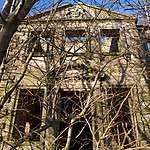 | |||
| Upper Largo Largo Home Farm Sir Andrew Wood's Tower | 56°13′16″N 2°56′15″W | Category B | 8986 | | |||
| Upper Largo Largo Parish Church And Church Yard | 56°13′14″N 2°55′51″W | Category B | 8989 | 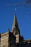 | |||
| Upper Largo 3 North Feus Rose Cottage | 56°13′16″N 2°55′51″W | Category B | 8993 | | |||
| Lower Largo Bridgend House And Out Buildings | 56°12′45″N 2°56′28″W | Category C(S) | 8936 | | |||
| Lower Largo 21 And 23 Main Street, Old Manse | 56°12′44″N 2°56′24″W | Category B | 8943 | | |||
| Lundin Links 15 Crescent Road (Old Calabar) | 56°12′47″N 2°57′03″W | Category B | 8949 | | |||
| Lundin Links 23 Largo Road | 56°12′58″N 2°56′53″W | Category C(S) | 8952 | | |||
| Strathairly Lodge | 56°13′17″N 2°55′08″W | Category B | 8961 | | |||
| Upper Largo 14 South Feus South View | 56°13′10″N 2°55′43″W | Category C(S) | 8971 | | |||
| Upper Largo Largo Road Eaglegate Lodge | 56°13′03″N 2°55′54″W | Category C(S) | 8990 | | |||
| Upper Largo St Andrews Road Lyndhurst | 56°13′19″N 2°55′39″W | Category B | 8995 | |
Key
The scheme for classifying buildings in Scotland is:
- Category A: "buildings of national or international importance, either architectural or historic; or fine, little-altered examples of some particular period, style or building type."[1]
- Category B: "buildings of regional or more than local importance; or major examples of some particular period, style or building type, which may have been altered."[1]
- Category C: "buildings of local importance; lesser examples of any period, style, or building type, as originally constructed or moderately altered; and simple traditional buildings which group well with other listed buildings."[1]
In March 2016 there were 47,288 listed buildings in Scotland. Of these, 8% were Category A, and 50% were Category B, with the remaining 42% being Category C.[2]
gollark: No.
gollark: Why not (pre)^npreludes for all positive integer n?
gollark: You have a parser which you want to rewrite anyway and vague pictures of a logic interpreter/logic spec, I have a sort of working application which admittedly does not do much of what "minoteaur" is to contain.
gollark: Even Minoteaur is more implemented than Macron.
gollark: Oh. I meant that ironically.
See also
Notes
- Sometimes known as OSGB36, the grid reference (where provided) is based on the British national grid reference system used by the Ordnance Survey.
• "Guide to National Grid". Ordnance Survey. Retrieved 2007-12-12.
• "Get-a-map". Ordnance Survey. Retrieved 2007-12-17. - Historic Environment Scotland assign a unique alphanumeric identifier to each designated site in Scotland, for listed buildings this always begins with "LB", for example "LB12345".
References
- All entries, addresses and coordinates are based on data from Historic Scotland. This data falls under the Open Government Licence
- "What is Listing?". Historic Environment Scotland. Retrieved 29 May 2018.
- Scotland's Historic Environment Audit 2016 (PDF). Historic Environment Scotland and the Built Environment Forum Scotland. pp. 15–16. Retrieved 29 May 2018.
This article is issued from Wikipedia. The text is licensed under Creative Commons - Attribution - Sharealike. Additional terms may apply for the media files.