List of listed buildings in Kinnell, Angus
List
| Name | Location | Date Listed | Grid Ref. [note 1] | Geo-coordinates | Notes | LB Number [note 2] | Image |
|---|---|---|---|---|---|---|---|
| Old Schoolhouse, Muirside Of Kinnell | 56°39′35″N 2°38′43″W | Category C(S) | 12324 |  | |||
| Willanyards Farmhouse | 56°40′13″N 2°36′47″W | Category B | 12326 | | |||
| Former Kinnell Parish Church Graveyard Including Gatepiers, Gates And Enclosure Walls | 56°38′34″N 2°38′22″W | Category C(S) | 51307 | | |||
| Kinnells Mill - Gate Piers | 56°38′30″N 2°38′34″W | Category B | 12322 | | |||
| Kinnells Mill - Granary And Cottages | 56°38′31″N 2°38′36″W | Category B | 12323 | | |||
| Kinnells Mill Bridge Over Lunan Water | 56°38′28″N 2°38′38″W | Category B | 13815 | | |||
| Kinnells Mill Farmhouse | 56°38′30″N 2°38′44″W | Category B | 12321 | | |||
| Braikie Castle | 56°38′54″N 2°36′27″W | Category A | 12325 | 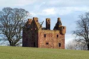 |
Key
The scheme for classifying buildings in Scotland is:
- Category A: "buildings of national or international importance, either architectural or historic; or fine, little-altered examples of some particular period, style or building type."[1]
- Category B: "buildings of regional or more than local importance; or major examples of some particular period, style or building type, which may have been altered."[1]
- Category C: "buildings of local importance; lesser examples of any period, style, or building type, as originally constructed or moderately altered; and simple traditional buildings which group well with other listed buildings."[1]
In March 2016 there were 47,288 listed buildings in Scotland. Of these, 8% were Category A, and 50% were Category B, with the remaining 42% being Category C.[2]
gollark: The Android ones.
gollark: I think BlackBerry phones?
gollark: On *some* Android phones you can't root it at all because they lock the bootloaders.
gollark: On Android you still need to root your phone to do much.
gollark: I am *very* easily distracted.
See also
Notes
- Sometimes known as OSGB36, the grid reference (where provided) is based on the British national grid reference system used by the Ordnance Survey.
• "Guide to National Grid". Ordnance Survey. Retrieved 2007-12-12.
• "Get-a-map". Ordnance Survey. Retrieved 2007-12-17. - Historic Environment Scotland assign a unique alphanumeric identifier to each designated site in Scotland, for listed buildings this always begins with "LB", for example "LB12345".
References
- All entries, addresses and coordinates are based on data from Historic Scotland. This data falls under the Open Government Licence
- "What is Listing?". Historic Environment Scotland. Retrieved 29 May 2018.
- Scotland's Historic Environment Audit 2016 (PDF). Historic Environment Scotland and the Built Environment Forum Scotland. pp. 15–16. Retrieved 29 May 2018.
This article is issued from Wikipedia. The text is licensed under Creative Commons - Attribution - Sharealike. Additional terms may apply for the media files.