List of listed buildings in Kingsbarns, Fife
List
| Name | Location | Date Listed | Grid Ref. [note 1] | Geo-coordinates | Notes | LB Number [note 2] | Image |
|---|---|---|---|---|---|---|---|
| Briar Rose And Croft Cottage North Street | 56°18′03″N 2°39′26″W | Category B | 13694 |  | |||
| Randerston Farm | 56°17′15″N 2°38′05″W | Category C(S) | 8797 | | |||
| Kingsbarns Parish Churchyard Sepulchral Monument To Corstorphines Of Kingsbarns | 56°17′58″N 2°39′32″W | Category B | 8710 | | |||
| Kingsbarns Parish Church The Square And Main Street | 56°17′58″N 2°39′34″W | Category B | 8718 | 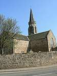 | |||
| Monypenny House Seagate | 56°17′58″N 2°39′27″W | Category C(S) | 8723 | | |||
| St Anne's And South Quarter Cottages Seagate | 56°17′59″N 2°39′25″W | Category C(S) | 8724 | | |||
| Crombie's Hall Main Street | 56°17′54″N 2°39′35″W | Category C(S) | 8730 | | |||
| Cambo Arms Hotel Main Street Including Out-Buildings, Car Park Walls, And Gateway | 56°17′59″N 2°39′34″W | Category B | 8733 | | |||
| South Quarter Farmhouse | 56°17′53″N 2°39′27″W | Category B | 8738 | | |||
| Smithy House (Incorporating Former Smithy) Station Road | 56°17′57″N 2°39′40″W | Category B | 8751 | | |||
| Kippo Doocot | 56°17′08″N 2°41′01″W | Category B | 8753 | | |||
| Rose Cottage (Miss Scott) Including Garden Walls | 56°17′56″N 2°39′26″W | Category C(S) | 8776 | | |||
| Former Joiner's Shop Now Farm Store Of South Quarter Farm | 56°17′56″N 2°39′26″W | Category C(S) | 8777 | | |||
| Cambo Dovecot | 56°17′32″N 2°38′48″W | Category B | 8793 | | |||
| Cambo Estate, Cambo House, Run Of Six Iron Footbridges Over Burn | 56°17′39″N 2°38′28″W | Category B | 13195 | | |||
| Kingsbarns Parish Churchyard The Square And Main Street | 56°17′58″N 2°39′33″W | Category C(S) | 8711 | | |||
| Woodside Cottage Back Style | 56°17′56″N 2°39′22″W | Category C(S) | 8716 | | |||
| Cottages, Now Out-Buildings Of Cesneuk, Off Main Street And Square | 56°17′56″N 2°39′31″W | Category B | 8725 | | |||
| Balmerino And The Old Hoose (Ha Boag) Main Street | 56°17′54″N 2°39′32″W | Category C(S) | 8729 | | |||
| Parish Church Manse, Off Main Street, Including Garden Walls | 56°17′52″N 2°39′36″W | Category B | 8732 | | |||
| Daisybank North Street | 56°18′01″N 2°39′34″W | Category C(S) | 8741 | | |||
| Kippo Gatepiers | 56°17′21″N 2°41′17″W | Category B | 8754 | | |||
| Pitmilly - North Lodge | 56°18′47″N 2°41′02″W | Category C(S) | 8755 | | |||
| Garage, Formerly Cottage Croft Butts House North Street | 56°18′03″N 2°39′29″W | Category B | 8782 | | |||
| The Grey House The Square Including Garden Walls And Out-Buildings | 56°17′57″N 2°39′28″W | Category B | 8720 | | |||
| Dunholm And Mrs Blyth's Seagate | 56°17′57″N 2°39′27″W | Category B | 8721 | | |||
| House (Mr Spence) Including Out-Buildings To Rear, Seagate | 56°17′58″N 2°39′28″W | Category B | 8722 | | |||
| Hazeldean And No 9 Main Street | 56°17′55″N 2°39′32″W | Category C(S) | 8727 | | |||
| The Old Forge North Street Including Garden Walls And Garage | 56°18′03″N 2°39′27″W | Category C(S) | 8742 | | |||
| Westwood Cottage And Bon Accord The Square | 56°17′57″N 2°39′29″W | Category B | 8762 | | |||
| 4, 6 And 8 Lady Wynd | 56°17′57″N 2°39′26″W | Category B | 8778 | | |||
| Cambo Stables And Walled Garden | 56°17′32″N 2°38′31″W | Category B | 8792 | | |||
| Barns Cottage And Stella Maris (W B Anderson) The Square | 56°17′58″N 2°39′31″W | Category C(S) | 8714 | | |||
| Dunstan Cottage (Wellers) Off Main Street | 56°17′55″N 2°39′32″W | Category C(S) | 8726 | | |||
| North Quarter Steading Main Street | 56°18′01″N 2°39′36″W | Category C(S) | 8736 | | |||
| Former Bakehouse Torrie House Off Station Road | 56°18′00″N 2°39′38″W | Category B | 8747 | | |||
| No 1 The Pleasance Station Road | 56°17′58″N 2°39′37″W | Category B | 8748 | | |||
| Cambo Farm | 56°17′32″N 2°39′14″W | Category B | 8757 | | |||
| Cesneuk The Square | 56°17′56″N 2°39′32″W | Category B | 8760 | | |||
| Cottages (Findlay And Hill) Lady Wynd | 56°17′54″N 2°39′30″W | Category C(S) | 8775 | | |||
| Kingsbarns Parish Church - Session House The Square | 56°17′57″N 2°39′34″W | Category C(S) | 8719 | | |||
| Cameron Cottage And Rosebank, Main Street | 56°17′53″N 2°39′33″W | Category B | 8731 | | |||
| North Quarter House, Main Street, Including Garden Walls | 56°17′59″N 2°39′36″W | Category B | 8735 | | |||
| South Quarter Farm Steading Including Farmyard Walls | 56°17′54″N 2°39′28″W | Category B | 8739 | | |||
| Briar Cottages The Wynd | 56°18′02″N 2°39′28″W | Category B | 8744 | | |||
| Retreat Cottage Bell's Wynd | 56°18′01″N 2°39′27″W | Category B | 8745 | | |||
| Cambo Lodges And Gates | 56°17′10″N 2°38′59″W | Category B | 8758 | | |||
| Cherry Cottage North Street | 56°18′02″N 2°39′32″W | Category B | 8780 | | |||
| Boghall Farm, Byre | 56°18′54″N 2°40′01″W | Category B | 49657 | | |||
| Kingsbarns School Main Street | 56°17′55″N 2°39′35″W | Category B | 13693 | | |||
| Strathyre Main Street | 56°17′54″N 2°39′32″W | Category B | 8728 | | |||
| The Library Main Street | 56°18′00″N 2°39′36″W | Category B | 8737 | | |||
| Kingsbarns Smithy North Street | 56°18′00″N 2°39′34″W | Category B | 8740 | | |||
| St Margaret's (Miss Robertson) The Wynd | 56°18′02″N 2°39′29″W | Category C(S) | 8743 | | |||
| No 2 The Pleasance Garage Premises Station Road | 56°17′58″N 2°39′38″W | Category C(S) | 8750 | | |||
| Cambo Mausoleum | 56°17′24″N 2°38′50″W | Category B | 8794 | | |||
| East Newhall Farm | 56°17′15″N 2°38′33″W | Category B | 8795 |  | |||
| Village Pump The Square | 56°17′57″N 2°39′33″W | Category B | 8712 | | |||
| Wellgate, The Square Including Garden Walls | 56°17′56″N 2°39′32″W | Category B | 8715 | | |||
| Kingsbarns Farm Main Street And North Street | 56°18′02″N 2°39′35″W | Category B | 8734 | | |||
| No 2 The Pleasance Station Road | 56°17′58″N 2°39′38″W | Category B | 8749 | | |||
| Hillhead Icehouse | 56°18′56″N 2°40′57″W | Category C(S) | 8756 | | |||
| Cambo House | 56°17′39″N 2°38′30″W | Category B | 8759 | | |||
| Cottage, Kingsbarns Farm North Street | 56°18′02″N 2°39′32″W | Category B | 8779 | | |||
| May Cottage North Street | 56°18′02″N 2°39′32″W | Category B | 8781 | | |||
| Randerston Farm House | 56°17′18″N 2°38′02″W | Category A | 8796 | | |||
| Schoolhouse The Square | 56°17′58″N 2°39′31″W | Category B | 8713 | | |||
| Ladyville Lady Wynd | 56°17′54″N 2°39′31″W | Category C(S) | 8717 | | |||
| Torrie House Off Station Road | 56°18′00″N 2°39′38″W | Category B | 8746 | | |||
| Kippo Farmhouse | 56°17′04″N 2°40′56″W | Category B | 8752 | | |||
| Kingsbarns House The Square Including Garden Walls And Out-Buildings | 56°17′57″N 2°39′30″W | Category B | 8761 | |
Key
The scheme for classifying buildings in Scotland is:
- Category A: "buildings of national or international importance, either architectural or historic; or fine, little-altered examples of some particular period, style or building type."[1]
- Category B: "buildings of regional or more than local importance; or major examples of some particular period, style or building type, which may have been altered."[1]
- Category C: "buildings of local importance; lesser examples of any period, style, or building type, as originally constructed or moderately altered; and simple traditional buildings which group well with other listed buildings."[1]
In March 2016 there were 47,288 listed buildings in Scotland. Of these, 8% were Category A, and 50% were Category B, with the remaining 42% being Category C.[2]
gollark: ++exec```luafunction factorial(x)local a = 1for i = 1, x do a = a * iendreturn aendfunction scream(x, a, b)if a == 0 thenif b == 0 thenreturn factorial(x) + 1else return math.pow(factorial(x), scream(factorial(x), 0, b - 1))endendlocal g = factorial(scream(x, a - 1, b))return math.pow(g, g) endprint(scream(5, 2, 2))```
gollark: ++exec```luafunction factorial(x)local a = 1for i = 1, x do a = a * iendreturn aendfunction scream(x, a, b)if a == 0 thenif b == 0 thenreturn factorial(x)else return factorial(x) + scream(factorial(x), 0, b - 1) endendlocal g = factorial(scream(x, a - 1, b))return math.pow(g, g) endprint(scream(5, 2, 2))```
gollark: ++exec```luafunction factorial(x)local a = 1for i = 1, x do a = a * iendreturn aendfunction scream(x, a, b)if a == 0 thenif b == 0 thenreturn factorial(x)else return math.pow(factorial(x), scream(factorial(x), 0, b - 1))endendlocal g = factorial(scream(x, a - 1, b))return math.pow(g, g) endprint(scream(5, 2, 2))```
gollark: ++exec```luafunction factorial(x)local a = 1for i = 1, x do a = a * iendreturn aendfunction scream(x, a, b)if a == 0 then if b == 0 then return factorial(x) else return math.pow(factorial(x), scream(factorial(x), 0, b - 1)) end endlocal p = factorial(scream(x, a - 1, b))return math.pow(g, g) endprint(scream(5, 2, 2))```
gollark: <@257604541300604928> <@319753218592866315> was a TRIANGLE and got rid of it.
See also
Notes
- Sometimes known as OSGB36, the grid reference (where provided) is based on the British national grid reference system used by the Ordnance Survey.
• "Guide to National Grid". Ordnance Survey. Retrieved 2007-12-12.
• "Get-a-map". Ordnance Survey. Retrieved 2007-12-17. - Historic Environment Scotland assign a unique alphanumeric identifier to each designated site in Scotland, for listed buildings this always begins with "LB", for example "LB12345".
References
- All entries, addresses and coordinates are based on data from Historic Scotland. This data falls under the Open Government Licence
- "What is Listing?". Historic Environment Scotland. Retrieved 29 May 2018.
- Scotland's Historic Environment Audit 2016 (PDF). Historic Environment Scotland and the Built Environment Forum Scotland. pp. 15–16. Retrieved 29 May 2018.
This article is issued from Wikipedia. The text is licensed under Creative Commons - Attribution - Sharealike. Additional terms may apply for the media files.