List of listed buildings in Kinghorn, Fife
List
| Name | Location | Date Listed | Grid Ref. [note 1] | Geo-coordinates | Notes | LB Number [note 2] | Image |
|---|---|---|---|---|---|---|---|
| 6 Cuinzie Neuk Including Stairway Within To No 7 | 56°04′14″N 3°10′27″W | Category B | 36248 |  | |||
| 36 North Overgate | 56°04′22″N 3°10′29″W | Category B | 36263 | | |||
| Raith Estate, Heather Lodge | 56°06′27″N 3°12′19″W | Category B | 9684 | | |||
| Easter Balbardie House Formerly East Balbardie Farmhouse And Steading | 56°05′29″N 3°13′39″W | Category C(S) | 9701 | | |||
| Glassmount Dovecot | 56°05′00″N 3°12′48″W | Category B | 9705 | | |||
| 21-35 (Odd Nos), High Street, Cross Buildings | 56°04′12″N 3°10′28″W | Category B | 46842 | | |||
| 2-6 (Even Nos) High Street Including Gatepiers | 56°04′14″N 3°10′29″W | Category C(S) | 46844 | | |||
| 1 Kilcruik Road Including Gatepiers, Gates And Boundary Walls | 56°04′20″N 3°10′40″W | Category B | 46847 | | |||
| Rossland Place, Railway Bridge No 72 | 56°04′05″N 3°10′32″W | Category C(S) | 46858 | | |||
| St Leonard's Place, Archway Motors, Former St Leonard's Mill | 56°04′19″N 3°10′29″W | Category C(S) | 46860 | | |||
| 4 St Leonard's Place, Former Gatehouse To St Leonard's Mill Including Boundary Walls | 56°04′18″N 3°10′27″W | Category C(S) | 46861 | | |||
| Abden Farm | 56°04′35″N 3°10′25″W | Category B | 46863 | | |||
| Kilrie House, Walled Garden | 56°05′40″N 3°12′58″W | Category C(S) | 46872 | | |||
| Lambert's Mill Bridge | 56°05′46″N 3°14′14″W | Category C(S) | 46873 | | |||
| 34 And 36 Nethergate | 56°04′12″N 3°10′21″W | Category B | 36245 | | |||
| 2-12 (Even Nos) Castle Wyn (Formerly 24 High Street) | 56°04′13″N 3°10′30″W | Category C(S) | 36249 | | |||
| 25 North Overgate Including Boundary Walls | 56°04′20″N 3°10′29″W | Category B | 36253 | | |||
| 2 Glamis Road Including Boundary Walls | 56°04′21″N 3°10′30″W | Category C(S) | 36254 | | |||
| 6, 7 And 9 Townhead And Barclay Road, Including Boundary Walls | 56°04′21″N 3°10′36″W | Category C(S) | 36257 | | |||
| Nether Pitteadie (Formerly North Pitteadie Farm) Including Dovecot, Walled Garden And Ancillary Buildings, Gatepiers And Boundary Walls | 56°05′41″N 3°12′22″W | Category B | 9699 | | |||
| Kilrie Dovecot | 56°05′38″N 3°13′04″W | Category B | 9703 | | |||
| Seafield Tower | 56°05′03″N 3°09′34″W | Category B | 9710 | 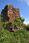 | |||
| Glamis Road, James Hay Joiner, Former Plash Mill With Ancillary Buildings And Boundary Walls | 56°04′20″N 3°10′32″W | Category B | 46838 | | |||
| Harbour Road, Railway Footbridge | 56°04′08″N 3°10′29″W | Category C(S) | 46839 | | |||
| 14 And 16 North Overgate, Glover's Court Including Boundary Walls | 56°04′21″N 3°10′27″W | Category C(S) | 46853 | | |||
| Balmuto Bridge Over Tributary To Tiel Burn | 56°05′37″N 3°15′03″W | Category C(S) | 46864 | | |||
| 1 , 2 And 3 St James Place | 56°04′10″N 3°10′21″W | Category C(S) | 36243 | | |||
| 28 - 32 (Even Nos) Nethergate And Harbour Road | 56°04′12″N 3°10′22″W | Category B | 36244 | | |||
| 40 Nethergate, Seagate House | 56°04′11″N 3°10′21″W | Category C(S) | 36247 | | |||
| 16 And 18 Eastgate Including Boundary Walls | 56°04′24″N 3°10′28″W | Category C(S) | 36266 | | |||
| Raith Estate, Coupie Craigs Bridge Over Dronachy Burn | 56°06′30″N 3°12′26″W | Category C(S) | 9685 | | |||
| Spanish Cottage And Datie Mill | 56°06′28″N 3°11′18″W | Category B | 9700 | | |||
| Inchkeith Island, Lighthouse And Remains Of Inchkeith Fort And Boundary Walls | 56°02′01″N 3°08′10″W | Category B | 9707 | | |||
| 17 Rossland Place, Rossland House | 56°04′07″N 3°10′32″W | Category C(S) | 46855 | | |||
| 14 Rossland Place | 56°04′06″N 3°10′33″W | Category C(S) | 46857 | | |||
| Rossland Place, War Memorial | 56°04′08″N 3°10′34″W | Category C(S) | 46859 | | |||
| 9 St Leonard's Place And South Overgate, Julian Memorial Hall Including Boundary Walls | 56°04′18″N 3°10′25″W | Category C(S) | 46862 | | |||
| Kilrie Gate, East Lodge | 56°05′26″N 3°12′47″W | Category C(S) | 46871 | | |||
| Nethergate, Kinghorn Parish Church Of St Leonard (Church Of Scotland) | 56°04′11″N 3°10′17″W | Category B | 36241 | 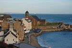 | |||
| Nethergate, Kinghorn Old Kirk | 56°04′12″N 3°10′16″W | Category C(S) | 36242 | | |||
| West Balbardie Lodge | 56°05′29″N 3°14′40″W | Category C(S) | 13003 | | |||
| Harbour Road, Railway Viaduct | 56°04′12″N 3°10′22″W | Category C(S) | 46840 | | |||
| 1 High Street | 56°04′14″N 3°10′27″W | Category C(S) | 46841 | | |||
| 35 North Overgate | 56°04′21″N 3°10′30″W | Category C(S) | 46852 | | |||
| Drinkbetween Including Boundary Walls, Railings And Gates | 56°04′59″N 3°11′09″W | Category C(S) | 46868 | | |||
| 30 North Overgate | 56°04′22″N 3°10′29″W | Category C(S) | 36261 | | |||
| 38 North Overgate And Eastgate | 56°04′22″N 3°10′29″W | Category B | 36264 | | |||
| 1 And 3 Eastgate Including Boundary Walls | 56°04′23″N 3°10′29″W | Category B | 36265 | | |||
| Balmuto Tower Including Boundary, Garden And Terrace Walls And Gatepiers | 56°05′38″N 3°15′14″W | Category B | 9686 | | |||
| Grangehill House With Pavilions And Link Walls, Boundary Walls, Gatepiers And Gates | 56°04′02″N 3°11′29″W | Category B | 9698 | | |||
| Burntisland Road, Kinghorn Golf Club, Clubhouse Including Boundary Walls | 56°03′59″N 3°10′45″W | Category C(S) | 46835 | | |||
| Nethergate, 6 And 7 St Clair's Entry | 56°04′11″N 3°10′22″W | Category C(S) | 46850 | | |||
| Nethergate, Kinghorn Parish Church Graveyard With Stones, Boundary Walls, Gatepiers, Gates And Railings | 56°04′11″N 3°10′16″W | Category B | 46851 | | |||
| Pettycur Harbour | 56°03′45″N 3°10′51″W | Category C(S) | 46854 | | |||
| Glassmount Conservatory | 56°05′01″N 3°12′48″W | Category A | 46869 | | |||
| Raith Estate, West Balbarton Farmhouse Including Walled Garden | 56°06′30″N 3°13′50″W | Category C(S) | 46874 | | |||
| Bruce Terrace, Bowbutts Dovecot | 56°04′25″N 3°10′25″W | Category B | 36268 | | |||
| 38 Nethergate (3 St Clair's Entry) | 56°04′12″N 3°10′21″W | Category B | 36246 | | |||
| Grange House Including Walled Garden, Boundary Walls And Gates | 56°05′03″N 3°10′26″W | Category C(S) | 9696 | | |||
| Glassmount Sundial | 56°05′02″N 3°12′43″W | Category C(S) | 9706 | | |||
| 37-39 (Odd Nos) High Street | 56°04′12″N 3°10′29″W | Category C(S) | 46843 | | |||
| Nethergate, 4 St Clair's Entry | 56°04′11″N 3°10′22″W | Category B | 46849 | | |||
| 4 North Overgate Including Boundary Walls | 56°04′20″N 3°10′26″W | Category B | 36260 | | |||
| 34 North Overgate | 56°04′22″N 3°10′29″W | Category B | 36262 | | |||
| Kinghorn Road, Alexander Iii Monument | 56°03′52″N 3°12′00″W | Category B | 13639 | | |||
| West Balbardie Including Gatepiers | 56°05′32″N 3°14′38″W | Category C(S) | 9687 | | |||
| Inchkeith Island, Batteries | 56°01′47″N 3°08′02″W | Category B | 9709 | | |||
| Inch View, Railway Tunnel No 71A | 56°03′57″N 3°10′49″W | Category C(S) | 46846 | | |||
| 8 Rossland Place Including Boundary Walls | 56°04′07″N 3°10′34″W | Category C(S) | 46856 | | |||
| Banchory Including Walled Garden, Boundary Walls And Gates | 56°04′55″N 3°11′24″W | Category C(S) | 46865 | | |||
| Bruce Terrace, Bowbutts House With Ancillary Building | 56°04′25″N 3°10′26″W | Category A | 36267 | | |||
| Bruce Terrace, Bowbutts Gatepiers, Gates And Enclosing Boundary Walls | 56°04′23″N 3°10′23″W | Category C(S) | 36269 | | |||
| Rossland Place, Public Library And Community Centre (Formerly Kinghorn Primary School) | 56°04′05″N 3°10′35″W | Category B | 36250 | | |||
| St Leonard's Place And North Overgate, Town House Including Boundary Walls, Exercise Yard And Railings | 56°04′18″N 3°10′26″W | Category B | 36251 | | |||
| 43 North Overgate | 56°04′22″N 3°10′31″W | Category C(S) | 36255 | | |||
| 1 Townhead Including Boundary Walls | 56°04′22″N 3°10′32″W | Category C(S) | 36256 | | |||
| Townhead, Kilcruik Cottage Including Boundary Walls | 56°04′21″N 3°10′38″W | Category C(S) | 36258 | | |||
| 2 North Overgate, Viewforth House Including Boundary Walls | 56°04′19″N 3°10′26″W | Category B | 36259 | | |||
| Pitteadie Castle Including Walled Garden | 56°05′21″N 3°11′42″W | Category B | 9697 | | |||
| Kilrie House Including Gatepiers | 56°05′42″N 3°12′52″W | Category B | 9702 | | |||
| Glassmount House | 56°05′02″N 3°12′46″W | Category C(S) | 9704 | | |||
| Inchkeith Island, Memorial To Lord Herbert Of Lea | 56°01′58″N 3°08′10″W | Category C(S) | 9708 | | |||
| 1 - 5 Cuinzie Neuk And Tron Gate | 56°04′14″N 3°10′27″W | Category C(S) | 46836 | | |||
| 20 Eastgate | 56°04′24″N 3°10′28″W | Category C(S) | 46837 | | |||
| 4 Kilcruik Road, The Manse Including Boundary Walls | 56°04′22″N 3°10′43″W | Category B | 46848 | | |||
| Banchory Farm, Grieves House With Ancillary Buildings | 56°04′54″N 3°11′18″W | Category C(S) | 46866 | | |||
| Craigencalt Farm Ecology Centre, Former Mill Building, Steading, The Hermitage And Ancillary Building | 56°04′30″N 3°11′32″W | Category C(S) | 46867 | | |||
| Glassmount Steading With Boundary Walls And Gatepiers | 56°05′01″N 3°12′52″W | Category B | 46870 | |
Key
The scheme for classifying buildings in Scotland is:
- Category A: "buildings of national or international importance, either architectural or historic; or fine, little-altered examples of some particular period, style or building type."[1]
- Category B: "buildings of regional or more than local importance; or major examples of some particular period, style or building type, which may have been altered."[1]
- Category C: "buildings of local importance; lesser examples of any period, style, or building type, as originally constructed or moderately altered; and simple traditional buildings which group well with other listed buildings."[1]
In March 2016 there were 47,288 listed buildings in Scotland. Of these, 8% were Category A, and 50% were Category B, with the remaining 42% being Category C.[2]
gollark: I don't think it does much though.
gollark: I mean, I use my computer's trackpad with both hands (not at the same time).
gollark: I have never interacted with a ”can opener”.
gollark: I'm right-handed but can do basically everything but writing with either hand, so meh.
gollark: Plus, you can amaze people by demonstrating that you have 10% more fingers than usual.
See also
Notes
- Sometimes known as OSGB36, the grid reference (where provided) is based on the British national grid reference system used by the Ordnance Survey.
• "Guide to National Grid". Ordnance Survey. Retrieved 12 December 2007.
• "Get-a-map". Ordnance Survey. Retrieved 17 December 2007. - Historic Environment Scotland assign a unique alphanumeric identifier to each designated site in Scotland, for listed buildings this always begins with "LB", for example "LB12345".
References
- All entries, addresses and coordinates are based on data from Historic Scotland. This data falls under the Open Government Licence
- "What is Listing?". Historic Environment Scotland. Retrieved 29 May 2018.
- Scotland's Historic Environment Audit 2016 (PDF). Historic Environment Scotland and the Built Environment Forum Scotland. pp. 15–16. Retrieved 29 May 2018.
This article is issued from Wikipedia. The text is licensed under Creative Commons - Attribution - Sharealike. Additional terms may apply for the media files.