List of listed buildings in Kilmarnock, East Ayrshire
List
| Name | Location | Date Listed | Grid Ref. [note 1] | Geo-coordinates | Notes | LB Number [note 2] | Image |
|---|---|---|---|---|---|---|---|
| St Marnock Street, Procurator Fiscal's Office (Former Court House) Including Boundary Walls And Railings | 55°36′28″N 4°29′57″W | Category B | 35964 |  | |||
| Turner Place, Highfield (Formerly Laigh Kirk Manse) | 55°37′15″N 4°29′26″W | Category C(S) | 35969 | | |||
| 6 Grange Street, The Artist's House | 55°36′36″N 4°30′00″W | Category B | 35899 | | |||
| 51 And 53 John Finnie Street | 55°36′33″N 4°29′59″W | Category B | 35911 | | |||
| Kay Park, Reformers' Monument | 55°36′52″N 4°29′22″W | Category B | 35926 |  | |||
| London Road, Henderson Church, Church Of Scotland | 55°36′26″N 4°29′04″W | Category C(S) | 35933 | 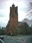 | |||
| 12 London Road, Including Boundary Wall And Gatepiers | 55°36′34″N 4°29′25″W | Category B | 35935 | | |||
| 21 - 29 (Odd Numbers) North Hamilton Street | 55°36′40″N 4°30′18″W | Category B | 35939 | | |||
| St Andrew's Street, St Andrew's Glencairn Church (Church Of Scotland), Including Churchyard And Boundary Walls | 55°36′13″N 4°29′38″W | Category B | 35959 | | |||
| Gardener's Cottage, Rowallan | 55°39′05″N 4°29′22″W | Category B | 12526 | | |||
| Stables, Rowallan | 55°39′15″N 4°29′23″W | Category B | 12528 | | |||
| Dean Road, Dean Bridge At Dean Castle | 55°37′25″N 4°28′58″W | Category C(S) | 48712 | | |||
| London Road, Green Bridge | 55°36′10″N 4°30′27″W | Category C(S) | 48725 | | |||
| Holehouse Road, 1 - 4 (Inclusive Numbers) Evelyn Villas, Boundary Walls And Gatepiers | 55°36′37″N 4°29′14″W | Category B | 48729 | | |||
| Howard Park, North And South Entrances, Gates And Railings | 55°36′21″N 4°30′02″W | Category C(S) | 48734 | | |||
| 5 And 7 Howard Street | 55°36′23″N 4°30′07″W | Category C(S) | 48736 | | |||
| 2 And 4 John Finnie Street And 26 West George Street, Former Ossington Hotel | 55°36′42″N 4°29′54″W | Category C(S) | 48740 | | |||
| Kay Park, Edward Vii Drinking Fountain | 55°36′46″N 4°29′21″W | Category B | 48741 | | |||
| 81 - 83 King Street (Odd Numbers) And 2 Water Lane | 55°36′30″N 4°29′50″W | Category C(S) | 48747 | | |||
| 2 And 4 Loanhead Street | 55°36′28″N 4°29′23″W | Category C(S) | 48750 | | |||
| 10 Loanhead Street Including Boundary Walls | 55°36′26″N 4°29′23″W | Category C(S) | 48754 | | |||
| Loanhead Street, Loanhead School, Including Janitor's House, Boundary Walls, Railings, Gatepiers And Playshelters | 55°36′25″N 4°29′29″W | Category B | 48755 | | |||
| 44 London Road Including Boundary Walls And Gatepiers | 55°36′28″N 4°29′04″W | Category C(S) | 48762 | | |||
| 51 - 63 (Odd Numbers) Portland Road, Formerly Portland Terrace | 55°36′31″N 4°30′23″W | Category C(S) | 48768 | | |||
| 10 - 16 (Even Nos) Portland Road | 55°36′27″N 4°30′05″W | Category B | 48769 | | |||
| 22 And 24 Portland Road | 55°36′28″N 4°30′07″W | Category B | 48771 | | |||
| 6 - 10 (Even Numbers) Queen Street | 55°36′28″N 4°29′47″W | Category C(S) | 48777 | | |||
| 1 Walker Avenue, Including Boundary Wall And Railings | 55°36′29″N 4°28′57″W | Category C(S) | 48792 | | |||
| Turner Place, Deanhill | 55°37′13″N 4°29′27″W | Category C(S) | 35970 | | |||
| West Langlands Street, Caledonia Works | 55°36′41″N 4°30′14″W | Category B | 35973 | | |||
| Ayr Road, Treesbank | 55°34′43″N 4°30′23″W | Category B | 35873 | | |||
| 3 And 5 Bank Street (Scotch Corner) And 8 College Wynd | 55°36′34″N 4°29′54″W | Category C(S) | 35877 | | |||
| 46 Bank Street, Bank Of Scotland | 55°36′32″N 4°29′54″W | Category B | 35880 | | |||
| Dundonald Road, The Parsonage Includung Boundary Wall And Gatepiers (To Holy Trinity Episcopal Church, Portland Road) | 55°36′27″N 4°30′02″W | Category B | 35885 | | |||
| 78 Dundonald Road, Westmont Including Boundary Walls And Gatepiers | 55°36′11″N 4°30′25″W | Category B | 35891 | | |||
| Elmbank Avenue, Dick Institute | 55°36′30″N 4°29′23″W | Category B | 35892 | 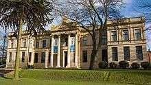 | |||
| 12 Grassyards Road, West Lodge Gateway And Gates To Kilmarnock Cemetery | 55°36′47″N 4°29′00″W | Category B | 35902 | | |||
| Green Street, Palace Theatre, Former Corn Exchange | 55°36′35″N 4°29′40″W | Category A | 35903 | 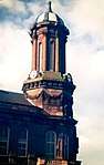 | |||
| 25 - 29 (Odd Numbers) John Finnie Street | 55°36′36″N 4°29′58″W | Category B | 35907 | | |||
| 39 And 41 John Finnie Street | 55°36′35″N 4°29′58″W | Category B | 35909 | | |||
| 75-79 (Odd Nos) John Finnie Street, George Tannahill And Sons | 55°36′30″N 4°30′00″W | Category B | 35914 | | |||
| John Finnie Street, District Council Offices | 55°36′37″N 4°29′56″W | Category B | 35918 | | |||
| 58 - 62 (Even Numbers) John Finnie Street | 55°36′35″N 4°29′57″W | Category B | 35920 | | |||
| 77 London Road, Deanmont | 55°36′36″N 4°29′05″W | Category B | 35932 | | |||
| 41 Portland Road, Etruria | 55°36′30″N 4°30′17″W | Category C(S) | 35945 | | |||
| Rowallan Castle | 55°39′00″N 4°29′21″W | Category A | 12523 | | |||
| Dean Road, Dean Castle Dower House | 55°37′24″N 4°29′03″W | Category B | 48713 | | |||
| 21 Hill Street (Veterinary Practice) And Boundary Walls | 55°36′50″N 4°29′52″W | Category C(S) | 48727 | | |||
| 107-111 (Odd Nos) King Street | 55°36′28″N 4°29′50″W | Category C(S) | 48748 | | |||
| 59 And 61 London Road | 55°36′28″N 4°29′13″W | Category C(S) | 48757 | | |||
| 20, 22 And 22A London Road | 55°36′32″N 4°29′18″W | Category C(S) | 48760 | | |||
| Sandbed Street, Sandbed Bridge | 55°36′34″N 4°29′50″W | Category C(S) | 48782 | | |||
| 3 Seaford Street Including Boundary Walls | 55°36′24″N 4°30′12″W | Category C(S) | 48783 | | |||
| Strand Street, Former Hays And Goldberg's Warehouse (And Johnnie Walker Whisky Bonds) | 55°36′37″N 4°29′52″W | Category B | 48784 | | |||
| 96-104 (Even Nos) Titchfield Street, Brigade Court | 55°36′18″N 4°29′49″W | Category C(S) | 48791 | | |||
| Grougar Road, Former Crookedholm School | 55°36′37″N 4°27′49″W | Category C(S) | 49867 | | |||
| Crookedholm, Main Road, Hurlford Church (Church Of Scotland), Formerly Reid Memorial Church With Boundary Wall And Church Hall | 55°36′11″N 4°27′19″W | Category C(S) | 50024 | | |||
| 1 And 3 St Marnock Place, 9 And 11 St Marnock Street, Former Borland's Seed Warehouse | 55°36′28″N 4°29′53″W | Category B | 35963 | | |||
| Soulis Street, High Church (Church Of Scotland), Including Churchyard, Walls, Gatepiers And Soulis Monument | 55°36′45″N 4°29′41″W | Category A | 35965 | | |||
| Dundonald Road, Winton Place Evangelical Union Congregational Church Including Hall, Boundary Walls And Railings | 55°36′26″N 4°30′02″W | Category B | 35886 |  | |||
| 8 Grange Terrace Including Boundary Wall | 55°36′34″N 4°30′52″W | Category C(S) | 35901 | | |||
| 16 - 28 (Even Numbers) John Finnie Street | 55°36′39″N 4°29′55″W | Category B | 35916 | | |||
| 72 - 84 (Even Numbers) John Finnie Street | 55°36′34″N 4°29′57″W | Category B | 35922 | | |||
| 36 And 38 London Road | 55°36′29″N 4°29′09″W | Category B | 35938 | | |||
| 37 Portland Road | 55°36′59″N 4°30′16″W | Category C(S) | 35944 | | |||
| Braeside Street, Kilmarnock Academy, Including Janitor's House, Boundary Walls, Gatepiers, Gates And Railings | 55°36′31″N 4°29′37″W | Category B | 35958 | 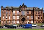 | |||
| Lodge, Rowallan | 55°38′46″N 4°29′21″W | Category B | 12525 | | |||
| Summerhouse And Walled Garden, Rowallan | 55°39′03″N 4°29′19″W | Category B | 12527 | | |||
| 36 - 40 (Even Nos) Bank Street | 55°36′33″N 4°29′53″W | Category C(S) | 48708 | | |||
| 1 - 14 (Inclusive Numbers) De Walden Terrace Including Boundary Walls And Outbuildings | 55°36′38″N 4°29′16″W | Category B | 48716 | | |||
| Elmbank Drive, Kilmarnock Equitable Co-Operative Society Drinking Fountain | 55°36′28″N 4°29′25″W | Category C(S) | 48721 | | |||
| 11, 13 (Glen Rosa) And 15 High Glencairn Street | 55°36′10″N 4°29′50″W | Category C(S) | 48726 | | |||
| Howard Park, Dr Alexander Marshall Monument | 55°36′11″N 4°30′09″W | Category B | 48730 | | |||
| Howard Park, Old Men's Hut | 55°36′15″N 4°30′08″W | Category C(S) | 48732 | | |||
| Crookedholm, Main Road, Former Hurlford Kirk And Manse, Including Boundary Walls And Gatepiers | 55°36′13″N 4°27′29″W | Category B | 42950 | | |||
| 26 - 34 (Even Nos) Bank Street | 55°36′34″N 4°29′53″W | Category C(S) | 35879 | | |||
| Dean Road, Dean Castle And Gatehouse | 55°37′23″N 4°29′01″W | Category A | 35884 | _at_Dean_Castle_in_Kilmarnock%2C_East_Ayrshire%2C_Scotland._http-en.wikipedia.org-wiki-Dean_Castle_-_panoramio.jpg) | |||
| 31 - 37 (Odd Numbers) John Finnie Street Laigh Kirk Mission Hall | 55°36′35″N 4°29′58″W | Category B | 35908 | | |||
| 55 And 57 John Finnie Street | 55°36′32″N 4°29′59″W | Category B | 35912 | | |||
| 6 - 14 (Even Numbers) John Finnie Street (Facade Only) | 55°36′40″N 4°29′55″W | Category B | 35915 | | |||
| Kilmarnock Railway Station | 55°36′44″N 4°29′57″W | Category B | 35928 | 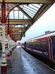 | |||
| 42 London Road (Formerly Hafton) Including Boundary Walls And Gatepiers | 55°36′29″N 4°29′07″W | Category B | 35941 | | |||
| Portland Road, Holy Trinity Episcopal Church Including Hall, Boundary Walls, Gatepiers And Milestone | 55°36′27″N 4°30′02″W | Category A | 35946 | 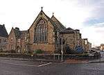 | |||
| Portland Road, Springhill House | 55°36′30″N 4°30′30″W | Category B | 35947 | | |||
| 78 And 80 Portland Street And 1 West George Street | 55°36′42″N 4°29′50″W | Category B | 35956 | | |||
| St Andrew's Street, St Andrew's Church Hall | 55°36′13″N 4°29′40″W | Category C(S) | 35960 | | |||
| Newhouse | 55°37′00″N 4°27′38″W | Category B | 12534 | | |||
| Dean Road, Dean Castle Lodge And Boundary Walls | 55°37′16″N 4°29′13″W | Category C(S) | 48714 | | |||
| 7 And 8 Howard Park Drive | 55°36′09″N 4°30′11″W | Category C(S) | 48735 | | |||
| 9-13 (Odd Nos) King Street | 55°36′35″N 4°29′49″W | Category C(S) | 48744 | | |||
| 73 London Road, Torwood | 55°36′27″N 4°29′06″W | Category C(S) | 48758 | | |||
| 1 And 3 Portland Road | 55°36′28″N 4°30′00″W | Category C(S) | 48767 | | |||
| 18 And 20 Portland Road | 55°36′28″N 4°30′06″W | Category B | 48770 | | |||
| 26 Portland Road | 55°36′28″N 4°30′08″W | Category B | 48772 | | |||
| 12 Queen Street | 55°36′28″N 4°29′47″W | Category C(S) | 48778 | | |||
| St Marnock Street, Road Bridge | 55°36′27″N 4°29′52″W | Category C(S) | 48780 | | |||
| 47 - 71 (Odd Numbers) Titchfield Street | 55°36′21″N 4°29′51″W | Category C(S) | 48787 | | |||
| 90 - 94 (Even Numbers) Titchfield Street | 55°36′18″N 4°29′49″W | Category C(S) | 48790 | | |||
| 13 - 15 (Odd Numbers) West George Street | 55°36′42″N 4°29′52″W | Category B | 48793 | | |||
| 44 And 46 Wellington Street Including Gatepiers And Boundary Walls | 55°36′55″N 4°29′44″W | Category C(S) | 35972 | | |||
| Bank Street, The Laigh Kirk | 55°36′35″N 4°29′52″W | Category A | 35875 | .jpg) | |||
| 3 Dundonald Road | 55°36′25″N 4°30′02″W | Category C(S) | 35887 | | |||
| 52 Dundonald Road Including Boundary Wall And Gatepier | 55°36′15″N 4°30′15″W | Category C(S) | 35889 | | |||
| 56 And 58 Dundonald Road, Invermay And Edelweiss | 55°36′14″N 4°30′17″W | Category C(S) | 35890 | | |||
| 10 Grange Place, Formerly Kilmarnock Standard Printing Office | 55°36′33″N 4°30′01″W | Category B | 35895 | | |||
| 5-9 (Odd Numbers) Grange Place | 55°36′33″N 4°30′01″W | Category B | 35898 | | |||
| 6 Grange Terrace Including Outbuilding And Boundary Wall | 55°36′35″N 4°30′51″W | Category C(S) | 35900 | | |||
| 43-49 (Odd Nos) John Finnie Street | 55°36′34″N 4°29′59″W | Category C(S) | 35910 | | |||
| 30 - 38 (Even Numbers) John Finnie Street | 55°36′39″N 4°29′55″W | Category B | 35917 | | |||
| 108 - 114 (Even Numbers) John Finnie Street (Former Kilmarnock Arms) | 55°36′30″N 4°29′58″W | Category C(S) | 35924 | | |||
| Kilmarnock Railway Station, Subway To Garden Street | 55°36′44″N 4°29′55″W | Category C(S) | 35929 | | |||
| 40 And 40A London Road, Formerly Elmslie | 55°36′29″N 4°29′08″W | Category B | 35940 | | |||
| Portland Road, The Lodge, Springhill House | 55°36′29″N 4°30′24″W | Category B | 35948 | | |||
| Portland Street, West High Church Of Scotland And Boundary Walls | 55°36′45″N 4°29′48″W | Category B | 35957 | | |||
| Crawfurdland Castle | 55°38′10″N 4°27′17″W | Category A | 12530 | | |||
| Crawfurdland Mains | 55°38′18″N 4°27′14″W | Category C(S) | 12531 | | |||
| Crawfurdland Bridge | 55°38′27″N 4°26′34″W | Category B | 12533 | | |||
| Western Road, Former Southhook Pottery, Including Gates, Gatepiers, Boundary Walls And Railings | 55°36′57″N 4°30′45″W | Category B | 47422 | | |||
| 42 Bank Street | 55°36′33″N 4°29′54″W | Category B | 48709 | | |||
| Dean Road (Near), Lauder Foot Bridge | 55°37′11″N 4°29′04″W | Category C(S) | 48715 | | |||
| 1-3 Dunlop Street And 12 Strand Street | 55°36′39″N 4°29′54″W | Category C(S) | 48720 | | |||
| Kay Park Terrace, Edward Viii Pillar Box | 55°36′41″N 4°29′05″W | Category B | 48742 | | |||
| Kilmarnock Station, K6 Telephone Kiosk | 55°36′41″N 4°30′02″W | Category B | 48743 | | |||
| 57 - 65 (Odd Numbers) King Street And 22 Sandbed Street, Victoria Buildings | 55°36′31″N 4°29′50″W | Category C(S) | 48746 | | |||
| Lawson Street, Belford Mill (Formerly Fleming's Lace Mill) | 55°36′10″N 4°29′34″W | Category B | 48749 | | |||
| 75 London Road Including Boundary Wall And Gatepier | 55°36′26″N 4°29′05″W | Category C(S) | 48759 | | |||
| 30 Samson Avenue, Provost Lamp | 55°36′19″N 4°28′55″W | Category B | 48781 | | |||
| 24 Titchfield Street, Former King's Theatre And Abc Cinema | 55°36′22″N 4°29′48″W | Category B | 48789 | | |||
| Dundonald Road, Mount House Including Gatepiers And Railings | 55°36′07″N 4°31′35″W | Category B | 43910 | | |||
| Bank Street, Laigh Kirk Graveyard And Gatepiers | 55°36′35″N 4°29′53″W | Category B | 35876 | | |||
| 3 Grange Place | 55°36′33″N 4°30′00″W | Category C(S) | 35897 | | |||
| 3-9 (Odd Numbers) John Finnie Street, Kilmarnock Club | 55°36′37″N 4°29′57″W | Category B | 35905 | | |||
| John Finnie Street, Council Chambers | 55°36′36″N 4°29′55″W | Category B | 35919 | | |||
| 100 - 106 (Even Numbers) John Finnie Street | 55°36′31″N 4°29′58″W | Category C(S) | 35923 | | |||
| Kay Park, Burns Monument And Former Museum | 55°36′46″N 4°29′23″W | Category B | 35925 | 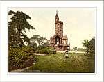 | |||
| 71 London Road, Including Boundary Walls And Gate Piers | 55°36′27″N 4°29′07″W | Category B | 35931 | | |||
| Portland Road, Former Stables And Boundary Wall To Springhill House | 55°36′29″N 4°30′29″W | Category B | 35949 | | |||
| Portland Street And Soulis Street, Viaduct | 55°36′43″N 4°29′45″W | Category B | 35951 | | |||
| 1 - 9 (Odd Numbers) Portland Street, Former Royal Bank Of Scotland | 55°36′37″N 4°29′47″W | Category B | 35952 | | |||
| Rowallan - | 55°39′10″N 4°29′33″W | Category A | 12524 | | |||
| Assloss | 55°37′47″N 4°28′07″W | Category B | 12529 | | |||
| 1 Bank Place, Kilmarnock Standard | 55°36′33″N 4°29′56″W | Category C(S) | 48706 | | |||
| 82 Dundonald Road | 55°36′10″N 4°30′27″W | Category C(S) | 48718 | | |||
| Glasgow Road, Milestone (Opposite End Of Arran Avenue) | 55°37′25″N 4°29′20″W | Category C(S) | 48723 | | |||
| Hill Street, St Joseph's Catholic Church And Priest's House | 55°36′49″N 4°29′50″W | Category B | 48728 | | |||
| Howard Park, Park Keeper's House | 55°36′14″N 4°30′10″W | Category C(S) | 48733 | | |||
| 47 And 47A London Road | 55°36′30″N 4°29′20″W | Category B | 48756 | | |||
| 70 London Road, Stanely | 55°36′25″N 4°28′43″W | Category C(S) | 48763 | | |||
| 2 And 4 Low Glencairn Street, Former Co - Operative Building | 55°36′03″N 4°29′48″W | Category C(S) | 48766 | | |||
| 28 And 30 Portland Road | 55°36′28″N 4°30′09″W | Category B | 48776 | | |||
| 32 Sturrock Street, Lilymount | 55°36′24″N 4°29′39″W | Category C(S) | 48785 | | |||
| West Shaw Street, Bridge | 55°36′04″N 4°30′02″W | Category C(S) | 48794 | | |||
| 47 Woodstock Street, Woodstock Cottage Including Boundary Walls And Railings | 55°36′35″N 4°30′14″W | Category C(S) | 48795 | | |||
| 3, 5 And 7 St Marnock Street And 113 - 119 (Odd Numbers) King Street | 55°36′27″N 4°29′50″W | Category C(S) | 35962 | | |||
| Woodstock Street, Grange Free Church, Including Hall, Boundary Walls, Railings And Gatepiers | 55°36′34″N 4°30′06″W | Category B | 35974 | | |||
| Campbell Street, New Riccarton Bridge | 55°35′50″N 4°29′50″W | Category C(S) | 35881 | | |||
| 5 Dundonald Road Including Boundary Walls And Outbuildings | 55°36′24″N 4°30′02″W | Category C(S) | 35888 | | |||
| London Road, Sir James Shaw's Statue | 55°36′32″N 4°29′25″W | Category B | 35930 | | |||
| St Marnock Street, St Marnock's Parish Church (Church Of Scotland) | 55°36′26″N 4°29′57″W | Category B | 35961 |  | |||
| 37 Bank Street And 20 Nelson Street | 55°36′31″N 4°29′57″W | Category C(S) | 48707 | | |||
| 58 - 62 (Even Nos) Bank Street And 22-24 (Even Nos) Nelson Street | 55°36′31″N 4°29′55″W | Category B | 48711 | | |||
| Elmbank Drive, War Memorial | 55°36′31″N 4°29′26″W | Category B | 48722 | 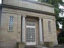 | |||
| Howard Park, Cholera Monument | 55°36′04″N 4°30′05″W | Category C(S) | 48731 | 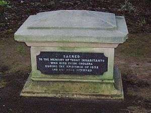 | |||
| 45 London Road, Kilmarnock Masonic Halls | 55°36′32″N 4°29′27″W | Category B | 48764 | | |||
| 5 - 7 (Odd Numbers) St Marnock Place | 55°36′30″N 4°29′52″W | Category C(S) | 48779 | | |||
| 141 - 145 (Odd Numbers) Titchfield Street And Douglas Street | 55°36′15″N 4°29′51″W | Category C(S) | 48788 | | |||
| 116-118 (Even Nos) John Finnie Street | 55°36′29″N 4°29′58″W | Category C(S) | 49625 | | |||
| 15 Strand Street, Formerly Part Of Hays And Goldberg's Warehouse | 55°36′36″N 4°29′51″W | Category C(S) | 35966 | | |||
| 24 Sturrock Street, Conservative Club, Including Boundary Wall | 55°36′30″N 4°29′42″W | Category B | 35967 | | |||
| 26 Sturrock Street, Former Reading Room | 55°36′30″N 4°29′43″W | Category C(S) | 35968 | | |||
| Ayr Road, Blacksyke Tower | 55°35′06″N 4°30′52″W | Category C(S) | 35872 | | |||
| Ayr Road, Stables At Treesbank | 55°34′44″N 4°30′25″W | Category C(S) | 35874 | | |||
| 7 Bank Street | 55°36′34″N 4°29′54″W | Category C(S) | 35878 | | |||
| Elmbank Avenue, Former Kilmarnock Technical School Including Gatepiers And Railings | 55°36′29″N 4°29′29″W | Category B | 35893 | | |||
| Elmbank Drive, St Columba's Primary School Including Bounday Wall, Gatepiers, Gates And Railings | 55°36′28″N 4°29′36″W | Category C(S) | 35894 | | |||
| 11 - 15 (Odd Numbers) Grange Place And 24 And 26 (Even Numbers) Grange Street, Formerly Wylie's Grain Store | 55°36′34″N 4°30′02″W | Category B | 35896 | | |||
| Irvine Road, Annanhill House (Former Kilmarnock Golf Club House) | 55°36′31″N 4°31′12″W | Category B | 35904 | | |||
| John Finnie Street, Central Evangelical Church | 55°36′36″N 4°29′58″W | Category C(S) | 35906 | | |||
| 73 John Finnie Street, Post Office | 55°36′31″N 4°30′00″W | Category B | 35913 | | |||
| 64 - 70 (Even Numbers) John Finnie Street | 55°36′34″N 4°29′57″W | Category B | 35921 | | |||
| 10 London Road | 55°36′33″N 4°29′26″W | Category C(S) | 35934 | | |||
| 14 London Road Including Boundary Walls And Gatepiers | 55°36′33″N 4°29′23″W | Category C(S) | 35936 | | |||
| 28 London Road, Rosehill, Including Boundary Wall And Gatepiers | 55°36′31″N 4°29′14″W | Category B | 35937 | | |||
| Old Street, Old Riccarton Bridge | 55°35′50″N 4°29′48″W | Category B | 35942 | 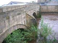 | |||
| Old Street, Riccarton Parish Church (Church Of Scotland), Including Boundary Walls, Gatepiers, Railings, Gates And Kirkyard | 55°35′45″N 4°29′45″W | Category B | 35943 | 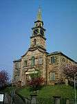 | |||
| Crawfurdland | 55°38′03″N 4°27′27″W | Category C(S) | 12532 | | |||
| 35 Dundonald Road, Boundary Wall And Corner Pier | 55°36′18″N 4°30′11″W | Category C(S) | 48717 | | |||
| 90 Dundonald Road, Auchenheath Including Boundary Wall And Gatepiers | 55°36′08″N 4°30′30″W | Category C(S) | 48719 | | |||
| 14 And 16 Glencairn Square, The Hunting Lodge | 55°36′03″N 4°29′47″W | Category C(S) | 48724 | | |||
| Irvine Road, Annanhill House, Walled Garden | 55°36′31″N 4°31′05″W | Category C(S) | 48737 | | |||
| 45-55 (Odd Nos) King Street, Formerly Lauder's Emporium | 55°36′32″N 4°29′50″W | Category C(S) | 48745 | | |||
| 6 And 8 Loanhead Street | 55°36′27″N 4°29′23″W | Category C(S) | 48751 | | |||
| 34 London Road | 55°36′30″N 4°29′10″W | Category C(S) | 48761 | | |||
| London Road, Milestone (To South West Of 18 London Road) | 55°36′32″N 4°29′21″W | Category C(S) | 48765 | | |||
| 43 Titchfield Street, Former Headquarters Of The 4Th Battalion Of The Royal Scots Fusiliers | 55°36′22″N 4°29′51″W | Category C(S) | 48786 | |
Key
The scheme for classifying buildings in Scotland is:
- Category A: "buildings of national or international importance, either architectural or historic; or fine, little-altered examples of some particular period, style or building type."[1]
- Category B: "buildings of regional or more than local importance; or major examples of some particular period, style or building type, which may have been altered."[1]
- Category C: "buildings of local importance; lesser examples of any period, style, or building type, as originally constructed or moderately altered; and simple traditional buildings which group well with other listed buildings."[1]
In March 2016 there were 47,288 listed buildings in Scotland. Of these, 8% were Category A, and 50% were Category B, with the remaining 42% being Category C.[2]
gollark: uncool.
gollark: ?help softban
gollark: ?info 550187576049270798
gollark: Just prepend leading zeros.
gollark: 5500?
Notes
- Sometimes known as OSGB36, the grid reference (where provided) is based on the British national grid reference system used by the Ordnance Survey.
• "Guide to National Grid". Ordnance Survey. Retrieved 2007-12-12.
• "Get-a-map". Ordnance Survey. Retrieved 2007-12-17. - Historic Environment Scotland assign a unique alphanumeric identifier to each designated site in Scotland, for listed buildings this always begins with "LB", for example "LB12345".
References
- All entries, addresses and coordinates are based on data from Historic Scotland. This data falls under the Open Government Licence
- "What is Listing?". Historic Environment Scotland. Retrieved 29 May 2018.
- Scotland's Historic Environment Audit 2016 (PDF). Historic Environment Scotland and the Built Environment Forum Scotland. pp. 15–16. Retrieved 29 May 2018.
This article is issued from Wikipedia. The text is licensed under Creative Commons - Attribution - Sharealike. Additional terms may apply for the media files.