List of listed buildings in Killean And Kilchenzie, Argyll and Bute
This is a list of listed buildings in the parish of Killean And Kilchenzie in Argyll and Bute, Scotland.
List
| Name | Location | Date Listed | Grid Ref. [note 1] | Geo-coordinates | Notes | LB Number [note 2] | Image |
|---|---|---|---|---|---|---|---|
| Killean House, Lodge, Gatepiers, Wing Walls And Railings | 55°38′19″N 5°39′50″W | Category B | 13074 |  | |||
| Killean House | 55°38′14″N 5°39′41″W | Category A | 12005 | 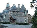 | |||
| Glencreggan House | 55°34′49″N 5°41′31″W | Category B | 12008 | | |||
| Macalister Of Glenbarr Burial Enclosure, Cladh Nam Paitean | 55°32′58″N 5°42′20″W | Category C(S) | 12011 | | |||
| Tangy Mill | 55°29′15″N 5°42′04″W | Category B | 12012 | | |||
| Killean And Kilchenzie Kirk A'Chleit | 55°36′52″N 5°41′01″W | Category A | 12035 | 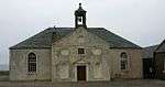 | |||
| Killean, Former School | 55°38′25″N 5°39′47″W | Category B | 43250 | | |||
| Killean Home Farm | 55°38′23″N 5°39′47″W | Category B | 12006 | | |||
| Barr House (Glenbarr Abbey) | 55°33′54″N 5°41′49″W | Category B | 12009 | | |||
| Barr Doocot | 55°33′53″N 5°42′01″W | Category C(S) | 12010 | | |||
| Muasdale Old Bridge, Clachaig Water | 55°36′01″N 5°41′03″W | Category C(S) | 12015 | | |||
| Killean, The "Dolls' Houses" | 55°38′27″N 5°39′47″W | Category A | 43266 | 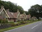 | |||
| St. Kenneth's Chapel, Kilchenzie Burial Ground | 55°27′44″N 5°40′53″W | Category C(S) | 13798 | | |||
| Killean Farmhouse | 55°38′20″N 5°39′48″W | Category B | 13073 | | |||
| Ballure House | 55°41′07″N 5°38′09″W | Category C(S) | 12013 | | |||
| Gortinanane House | 55°39′58″N 5°38′57″W | Category C(S) | 12014 | | |||
| Killean Chapel (St John's) Killean Burial Ground | 55°38′24″N 5°39′50″W | Category A | 12004 | | |||
| Tigh-Na-Cladaich (Formerly Killean And Kilchenzie Manse) Muasdale | 55°35′44″N 5°41′20″W | Category B | 12007 | | |||
| Drummore | 55°31′53″N 5°42′04″W | Category C(S) | 12016 | |
Key
The scheme for classifying buildings in Scotland is:
- Category A: "buildings of national or international importance, either architectural or historic; or fine, little-altered examples of some particular period, style or building type."[1]
- Category B: "buildings of regional or more than local importance; or major examples of some particular period, style or building type, which may have been altered."[1]
- Category C: "buildings of local importance; lesser examples of any period, style, or building type, as originally constructed or moderately altered; and simple traditional buildings which group well with other listed buildings."[1]
In March 2016 there were 47,288 listed buildings in Scotland. Of these, 8% were Category A, and 50% were Category B, with the remaining 42% being Category C.[2]
gollark: btw I use arch
gollark: It cheats by basically hibernating.
gollark: It always works fine for me if I press random function keys enough.
gollark: What if it just takes the complement of the set of the people to whom they are attracted?
gollark: ABR is back up.
Notes
- Sometimes known as OSGB36, the grid reference (where provided) is based on the British national grid reference system used by the Ordnance Survey.
• "Guide to National Grid". Ordnance Survey. Retrieved 2007-12-12.
• "Get-a-map". Ordnance Survey. Retrieved 2007-12-17. - Historic Environment Scotland assign a unique alphanumeric identifier to each designated site in Scotland, for listed buildings this always begins with "LB", for example "LB12345".
References
- All entries, addresses and coordinates are based on data from Historic Scotland. This data falls under the Open Government Licence
- "What is Listing?". Historic Environment Scotland. Retrieved 29 May 2018.
- Scotland's Historic Environment Audit 2016 (PDF). Historic Environment Scotland and the Built Environment Forum Scotland. pp. 15–16. Retrieved 29 May 2018.
This article is issued from Wikipedia. The text is licensed under Creative Commons - Attribution - Sharealike. Additional terms may apply for the media files.