List of listed buildings in Killarow And Kilmeny, Argyll and Bute
This is a list of listed buildings in the parish of Killarow And Kilmeny in Argyll and Bute, Scotland.
List
| Name | Location | Date Listed | Grid Ref. [note 1] | Geo-coordinates | Notes | LB Number [note 2] | Image |
|---|---|---|---|---|---|---|---|
| Bridgend Hotel And Steading | 55°46′51″N 6°14′57″W | Category C(S) | 12189 |  | |||
| House (Campbell) Shop, And Post Office By River Sorn | 55°46′53″N 6°14′59″W | Category C(S) | 12190 | | |||
| Islay Home Farm | 55°47′07″N 6°15′05″W | Category B | 12144 | | |||
| Bluehouse, Islay House Estate | 55°47′09″N 6°15′37″W | Category B | 12149 | | |||
| East Lodge And Gate-Way, Islay House Estate | 55°47′47″N 6°12′59″W | Category B | 12153 | | |||
| Store-House (D. Macbranes) Port Askaig Pier | 55°50′55″N 6°06′18″W | Category C(S) | 12166 | | |||
| John Francis Campbell Monument Rear St. Columba's Episcopal Church | 55°46′32″N 6°14′56″W | Category C(S) | 12188 | | |||
| Dry Bridge Over Bridgend-Ballygrant Road, Islay House Estate | 55°46′58″N 6°14′57″W | Category C(S) | 12145 | | |||
| Port Askaig Hotel | 55°50′52″N 6°06′20″W | Category C(S) | 12162 | | |||
| Houses (F.T. Spears) Shop | 55°50′53″N 6°06′21″W | Category C(S) | 12163 | | |||
| Port Askaig, Jetty | 55°50′53″N 6°06′17″W | Category C(S) | 12164 | | |||
| Piermasters Shipping Office (D. Macbranes) House And Post Office Port Askaig | 55°50′54″N 6°06′18″W | Category C(S) | 12165 | | |||
| Bridge, River Laggan Bowmore-Port Ellen Low Road | 55°43′51″N 6°17′11″W | Category C(S) | 12430 | | |||
| Rhuvaal Lighthouse, Rudh A' Mhail | 55°56′11″N 6°07′25″W | Category B | 12117 |  | |||
| Gardeners House And Gate Piers. Islay House Estate | 55°46′54″N 6°15′07″W | Category C(S) | 12146 | | |||
| East Tower Near Gate-Lodge Islay House Estate | 55°46′55″N 6°15′06″W | Category B | 12147 | | |||
| Eallabus House | 55°47′20″N 6°15′06″W | Category B | 12150 | | |||
| Dunlossit House Estate, Memorial Cross (Shaft) | 55°50′50″N 6°06′32″W | Category C(S) | 47367 | | |||
| Bridge House Beside Bridge Over River Laggan | 55°43′51″N 6°17′10″W | Category C(S) | 12431 | | |||
| Kilarrow Parish Church, Main Street | 55°45′18″N 6°17′11″W | Category A | 12184 | 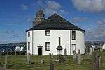 | |||
| Islay Woollen Mill And Bridge | 55°47′22″N 6°13′30″W | Category A | 12143 | 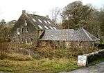 | |||
| Emeraconart Cottage | 55°48′34″N 6°11′54″W | Category C(S) | 12156 | | |||
| Dunlossit House | 55°50′45″N 6°06′15″W | Category C(S) | 12160 | | |||
| Island House | 55°43′43″N 6°17′24″W | Category B | 12187 | | |||
| West Tower, Islay House Estate | 55°47′02″N 6°16′24″W | Category B | 12148 | | |||
| Newton House | 55°47′04″N 6°14′12″W | Category C(S) | 12151 | | |||
| Daill House | 55°47′04″N 6°12′26″W | Category B | 12152 | | |||
| Kilmeny (Former Manse) | 55°48′48″N 6°10′16″W | Category B | 12155 | | |||
| Finlaggan Castle, Eilean Mor, Loch Finlaggan | 55°50′07″N 6°10′22″W | Category C(S) | 12158 | 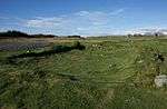 | |||
| Shore Street, House At Scws Filling Station | 55°45′26″N 6°17′11″W | Category B | 12429 | | |||
| Bridge, River Sorn | 55°46′54″N 6°14′58″W | Category B | 12191 | | |||
| Veterinary Surgery (Beside Bridge) River Sorn | 55°46′54″N 6°14′59″W | Category B | 12141 | | |||
| 61 Jamieson Street, Cottage | 55°45′24″N 6°17′05″W | Category C(S) | 12428 | | |||
| Islay House, Gateway At Entrance To Strand Legal Plantation | 55°46′54″N 6°15′05″W | Category C(S) | 12432 | | |||
| Town Hall, Main Street | 55°45′21″N 6°17′13″W | Category B | 12185 | | |||
| Cottage, (D. Gillies) 59-60 Jamieson Street | 55°45′24″N 6°17′05″W | Category C(S) | 12186 | | |||
| Bunnahabhan Distillery, Bonahaven Bay | 55°52′58″N 6°07′34″W | Category C(S) | 12116 | | |||
| Kilfinlaggan Chapel, Eilean Mor, Loch Finlaggan | 55°50′08″N 6°10′19″W | Category C(S) | 12159 | 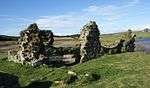 | |||
| Bowmore Village, High Street, Former Free Church Including Perimeter Wall And Gatepiers | 55°45′22″N 6°17′03″W | Category C(S) | 12947 | | |||
| Islay House | 55°47′05″N 6°15′15″W | Category A | 12142 | 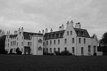 | |||
| Kilmeny Parish Church | 55°48′51″N 6°10′06″W | Category B | 12154 | | |||
| Knocklearoch Farm-House And Steading | 55°48′26″N 6°09′09″W | Category C(S) | 12157 | | |||
| Heatherhouse, Caol Ila | 55°51′04″N 6°07′04″W | Category B | 12161 | |
Key
The scheme for classifying buildings in Scotland is:
- Category A: "buildings of national or international importance, either architectural or historic; or fine, little-altered examples of some particular period, style or building type."[1]
- Category B: "buildings of regional or more than local importance; or major examples of some particular period, style or building type, which may have been altered."[1]
- Category C: "buildings of local importance; lesser examples of any period, style, or building type, as originally constructed or moderately altered; and simple traditional buildings which group well with other listed buildings."[1]
In March 2016 there were 47,288 listed buildings in Scotland. Of these, 8% were Category A, and 50% were Category B, with the remaining 42% being Category C.[2]
gollark: Observe, a rednet-addled user.
gollark: Spoofing!
gollark: There should at least be some sort of *warning*, like "note: IDs are spoofable".
gollark: Okay, that is true.
gollark: Security.
Notes
- Sometimes known as OSGB36, the grid reference (where provided) is based on the British national grid reference system used by the Ordnance Survey.
• "Guide to National Grid". Ordnance Survey. Retrieved 2007-12-12.
• "Get-a-map". Ordnance Survey. Retrieved 2007-12-17. - Historic Environment Scotland assign a unique alphanumeric identifier to each designated site in Scotland, for listed buildings this always begins with "LB", for example "LB12345".
References
- All entries, addresses and coordinates are based on data from Historic Scotland. This data falls under the Open Government Licence
- "What is Listing?". Historic Environment Scotland. Retrieved 29 May 2018.
- Scotland's Historic Environment Audit 2016 (PDF). Historic Environment Scotland and the Built Environment Forum Scotland. pp. 15–16. Retrieved 29 May 2018.
This article is issued from Wikipedia. The text is licensed under Creative Commons - Attribution - Sharealike. Additional terms may apply for the media files.