List of listed buildings in Kilchoman, Argyll and Bute
This is a list of listed buildings in the parish of Kilchoman on Islay in Argyll and Bute, Scotland.
List
| Name | Location | Date Listed | Grid Ref. [note 1] | Geo-coordinates | Notes | LB Number [note 2] | Image |
|---|---|---|---|---|---|---|---|
| Portnahaven School | 55°40′49″N 6°30′03″W | Category B | 12437 |  | |||
| Kilchiaran Farmhouse | 55°45′21″N 6°27′03″W | Category B | 11898 | | |||
| Bruichladdich Gorton Schoolhouse And Former School | 55°46′48″N 6°21′09″W | Category B | 11911 | | |||
| Houses, Main Street Sraid Ard (E. Side, Middle) 1. Mclellan 2. Clark 3. Kidd 4. Gillies 5. Mckinven 6 Rothschild | 55°44′21″N 6°22′41″W | Category B | 11928 | | |||
| Police Station And House (Lochview), Rathad Na Roinne (W. Side) | 55°44′12″N 6°22′54″W | Category C(S) | 11937 | | |||
| Houses Bruthach Dubh W. Side 1. Boyle 2. Leitch 3. Maclean 4. Gillespie 5. Mactaggart And Henderson 6. Donald 7. Macindeor 8. Mcdougall 9. Mackintosh | 55°44′24″N 6°22′44″W | Category B | 11948 | | |||
| "Rhu" By Port Na Ceasach, 1. Dick, 2. Mclelland | 55°44′17″N 6°22′43″W | Category B | 12436 | | |||
| Hugh Mackay's Grave, (Tung Mhic Aoidh Na Ranna) | 55°40′32″N 6°30′45″W | Category B | 11895 | | |||
| St. Ciaran's Chapel Kilchiaran | 55°45′12″N 6°27′25″W | Category B | 11897 | | |||
| Kilchiaran Steading | 55°45′19″N 6°27′12″W | Category B | 11899 | | |||
| Nave Island Chapel Nave Island | 55°53′58″N 6°20′01″W | Category B | 11909 | | |||
| 26, 27, 28 & 29 Shore Street (Sraid A'Chladdaich) (Middle) | 55°44′21″N 6°22′39″W | Category B | 11924 | | |||
| House, (Woodrow & Ross) Bruthach An Diolladair | 55°44′20″N 6°22′41″W | Category C(S) | 11927 | | |||
| Houses, Main Street (Sraid Ard) (W. Side, N. End) 1) Macarther, 2) Mcindeor 3) Miss Mcindeor 4) Fergusson 5) Mciver 6) Grier | 55°44′24″N 6°22′43″W | Category B | 11929 | | |||
| Houses, Main St. Sraid Ard (W. Side, S. End) 1) Mclelland, 2) Mcsween 3) Fergusson 4) Beattie | 55°44′19″N 6°22′45″W | Category B | 11931 | | |||
| 'Laggan View' Rathad Na Roinne (W. Side) | 55°44′17″N 6°22′47″W | Category C(S) | 11933 | | |||
| Portnahaven Church Of Scotland | 55°40′52″N 6°30′25″W | Category B | 11940 | .jpg) | |||
| Bonded Warehouses Lochindaal Distillery | 55°44′28″N 6°22′44″W | Category C(S) | 11947 | | |||
| Port Charlotte Hotel | 55°44′25″N 6°22′42″W | Category C(S) | 11949 | | |||
| Houses, Cnoc Iain Phail And Shore Street (Sraid A'Chladdaich) (N. End) 1) Storehouse, 2) Maciore, 3) Toirre, 4) Mactaggart And Maclean, 5) Johnson | 55°44′23″N 6°22′39″W | Category B | 13793 | | |||
| Brookfield (Old Manse) | 55°40′52″N 6°30′11″W | Category C(S) | 11942 | | |||
| Atlantic View (Fergusson's) | 55°40′48″N 6°30′21″W | Category C(S) | 11943 | | |||
| St. Oran's Chapel | 55°40′32″N 6°30′45″W | Category B | 11945 | | |||
| Kilchoman Manse, Bruichladdich - Port Charlotte Road | 55°44′53″N 6°22′28″W | Category C(S) | 11946 | | |||
| Houses 1. Mckinnon 2. Thomson | 55°40′35″N 6°30′18″W | Category B | 13792 | | |||
| Port Charlotte Road, Kilchoman New Parish Church (St Ciaran's), Bruichladdich | 55°45′06″N 6°22′22″W | Category B | 13818 | | |||
| Foreland House | 55°47′41″N 6°21′27″W | Category B | 11901 | | |||
| Lochindaal Hotel And Houses Main Street (Sraid Ard) (W. Side Middle) 1) Macdonald, 2) Carmichael, 3) Hotel, 4) Bar, 5) Miss Gillespie 6) Gillespie | 55°44′20″N 6°22′43″W | Category B | 11930 | | |||
| Kilchoman Old Parish Church Kilchoman | 55°46′55″N 6°26′30″W | Category B | 11902 | 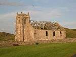 | |||
| Kilnave Chapel (Cill Naoimh), Kilnave Burial Ground | 55°51′37″N 6°20′25″W | Category B | 11905 | 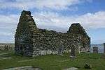 | |||
| Houses, Rathad Na Roinne (W. Side) 1. W. Campbell 2. S. Campbell | 55°44′16″N 6°22′48″W | Category C(S) | 11934 | | |||
| Old Blacksmith's House (Burke) Rathad Na Roinne (W. Side) | 55°44′15″N 6°22′49″W | Category C(S) | 11935 | | |||
| Bruichladdich Distillery | 55°45′58″N 6°21′43″W | Category C(S) | 11900 | 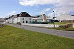 | |||
| Kilchoman Cross, Kilchoman Burial Ground | 55°46′54″N 6°26′30″W | Category B | 11903 | 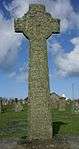 | |||
| Kilnave Cross, Kilnave Burial Ground | 55°51′37″N 6°20′25″W | Category B | 11906 | 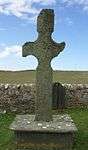 | |||
| Craigens Farmhouse And Steading | 55°49′19″N 6°18′59″W | Category B | 11910 | | |||
| 22, 23 & 24 Shore Street (Sraid A'Chladdaich) (S. End) | 55°44′20″N 6°22′40″W | Category B | 11925 | | |||
| House (Campbell) Bruthach An Diolladair | 55°44′20″N 6°22′41″W | Category C(S) | 11926 | | |||
| House, (Mctaggart) Rathad Na Roinne (W. Side) | 55°44′15″N 6°22′50″W | Category C(S) | 11936 | | |||
| "Achnamara" Rathad Na Roinne (E. Side) | 55°44′16″N 6°22′47″W | Category C(S) | 11938 | | |||
| Port Charlotte Village Sraid Na Sgoile Port Charlotte Village Hall | 55°44′20″N 6°22′49″W | Category B | 11941 | | |||
| Cottage (Belonging To Ferguson, Farmer) Near Balmenach | 55°41′28″N 6°30′12″W | Category B | 11896 | | |||
| Ardnave Steading | 55°52′26″N 6°20′45″W | Category B | 11908 | | |||
| Rhinns Of Islay Lighthouse | 55°40′23″N 6°30′48″W | Category A | 11944 | 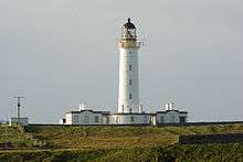 | |||
| Kilchoman House (Old Manse) Kilchoman | 55°46′52″N 6°26′27″W | Category B | 11904 | | |||
| Ardnave House | 55°52′25″N 6°20′42″W | Category B | 11907 | | |||
| Cottage, Rathad Na Roinne (W. Side) | 55°44′17″N 6°22′46″W | Category C(S) | 11932 | | |||
| Cottage, (Clark) Rathad Na Roinne (E. Side) | 55°44′16″N 6°22′47″W | Category C(S) | 11939 | |
Key
The scheme for classifying buildings in Scotland is:
- Category A: "buildings of national or international importance, either architectural or historic; or fine, little-altered examples of some particular period, style or building type."[1]
- Category B: "buildings of regional or more than local importance; or major examples of some particular period, style or building type, which may have been altered."[1]
- Category C: "buildings of local importance; lesser examples of any period, style, or building type, as originally constructed or moderately altered; and simple traditional buildings which group well with other listed buildings."[1]
In March 2016 there were 47,288 listed buildings in Scotland. Of these, 8% were Category A, and 50% were Category B, with the remaining 42% being Category C.[2]
gollark: How do you know?
gollark: Odd.
gollark: Just not that many.
gollark: I can afford SOME apiomonetary units.
gollark: furiously
Notes
- Sometimes known as OSGB36, the grid reference (where provided) is based on the British national grid reference system used by the Ordnance Survey.
• "Guide to National Grid". Ordnance Survey. Retrieved 2007-12-12.
• "Get-a-map". Ordnance Survey. Retrieved 2007-12-17. - Historic Environment Scotland assign a unique alphanumeric identifier to each designated site in Scotland, for listed buildings this always begins with "LB", for example "LB12345".
References
- All entries, addresses and coordinates are based on data from Historic Scotland. This data falls under the Open Government Licence
- "What is Listing?". Historic Environment Scotland. Retrieved 29 May 2018.
- Scotland's Historic Environment Audit 2016 (PDF). Historic Environment Scotland and the Built Environment Forum Scotland. pp. 15–16. Retrieved 29 May 2018.
This article is issued from Wikipedia. The text is licensed under Creative Commons - Attribution - Sharealike. Additional terms may apply for the media files.