List of listed buildings in Kilbrandon And Kilchattan, Argyll and Bute
This is a list of listed buildings in the parish of Kilbrandon And Kilchattan in Argyll and Bute, Scotland.
List
| Name | Location | Date Listed | Grid Ref. [note 1] | Geo-coordinates | Notes | LB Number [note 2] | Image |
|---|---|---|---|---|---|---|---|
| Ellanbeich, Comprising:- 1-24. Miss Campbell's Cottage, Harbour Tea Room (The Old Bakery), Shop,26,27 (Mr Connely's Cottage And Post Office) 28-42. Smith's Garage (Former Store-House) 61,60 Sealladh-Na-Mara 64 (The Old Inn) Monaveen Lodge | 56°17′39″N 5°38′55″W | Category B | 12425 |  | |||
| Toberonochy Comprising:- 1 (Seabank) 4, 5, 6, 7; 14, 15, 16; 18, 19, 20, 21, 22; 26 (Sherbrooke Cottage); 27, 28; 29; 30; 31, 32; Village Hall; 33; 34-35, 36, 37-38; 39, 40, 41, 42; Arizona Villa | 56°13′04″N 5°37′58″W | Category B | 12198 | | |||
| Luing Island Toberonochy Quay | 56°12′58″N 5°37′46″W | Category C(S) | 12199 | | |||
| Luing, 3 K6 Telephone Kiosks | 56°15′57″N 5°37′56″W | Category B | 12202 | | |||
| Ardmaddy Castle | 56°17′19″N 5°34′45″W | Category B | 12226 | 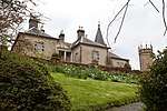 | |||
| Kilbrandon House | 56°16′43″N 5°36′38″W | Category B | 12230 | | |||
| 8, 100 And 6 Easdale Island | 56°17′30″N 5°39′16″W | Category C(S) | 48056 | | |||
| 9 Easdale Island | 56°17′30″N 5°39′17″W | Category C(S) | 48058 | | |||
| 34 And 35 Easdale Island | 56°17′28″N 5°39′23″W | Category C(S) | 48069 | | |||
| 41, 42, 43 Easdale Island | 56°17′30″N 5°39′24″W | Category C(S) | 48070 | | |||
| 47 Easdale Island | 56°17′31″N 5°39′25″W | Category C(S) | 48085 | | |||
| Cullipool, Comprising: Cullipool House 3,4,5,6,8,9,10,11,15,16,17,21,22,18,19,20,24,25,26,28,29,31,32,33,36,37,38,39, 40,41,42,43,44,45,47, Former St Peter's Episcopal Church | 56°15′23″N 5°39′02″W | Category B | 12424 | | |||
| Old Kilchattan Kirk | 56°13′15″N 5°38′22″W | Category B | 12196 | | |||
| Ellenbeich Quay At Sgeir Nam Ban And Sea Wall To South | 56°17′36″N 5°39′04″W | Category B | 12201 | | |||
| 2, 3, 4 And 5 Easdale Island, Including Garden Walls To Rear | 56°17′30″N 5°39′14″W | Category C(S) | 48055 | | |||
| Luing Island, Cullipool Quay | 56°15′06″N 5°39′16″W | Category B | 12200 | | |||
| Ardincaple House | 56°18′49″N 5°37′02″W | Category B | 12228 | | |||
| 12 And 12A Easdale Island | 56°17′28″N 5°39′16″W | Category C(S) | 48060 | | |||
| 29 Easdale Island Including Garden Wall To Rear | 56°17′27″N 5°39′15″W | Category C(S) | 48065 | | |||
| 50, 51, 52, 53 And 54 Easdale Island | 56°17′32″N 5°39′25″W | Category C(S) | 48077 | | |||
| Ellanabeich K6 Telephone Kiosk | 56°17′41″N 5°38′59″W | Category B | 12203 | | |||
| Tigh-An-Truish Hotel | 56°19′04″N 5°35′04″W | Category C(S) | 12227 | | |||
| Ardlarach Farmhouse | 56°13′10″N 5°39′14″W | Category B | 12197 | | |||
| 13 Easdale Island | 56°17′28″N 5°39′16″W | Category C(S) | 48061 | | |||
| 15 Easdale Island | 56°17′28″N 5°39′19″W | Category C(S) | 48063 | | |||
| 32, 18 And 19 Easdale Island Including Garden Walls To Rear | 56°17′29″N 5°39′20″W | Category C(S) | 48064 | | |||
| 31, 33A And 33 Easdale Island | 56°17′28″N 5°39′21″W | Category C(S) | 48068 | | |||
| Old Kilbrandon And Kilchattan Kirk North Cuan | 56°16′07″N 5°37′43″W | Category C(S) | 12195 | | |||
| Luing, Achafolla Mill | 56°13′45″N 5°38′35″W | Category C(S) | 47129 | | |||
| Easdale Island, Harbour Breastwork | 56°17′32″N 5°39′20″W | Category B | 48053 | | |||
| Easdale Island, The Drill Hall | 56°17′31″N 5°39′16″W | Category C(S) | 48057 | | |||
| 11, 11A, 11B Easdale Island | 56°17′29″N 5°39′15″W | Category C(S) | 48059 | | |||
| 23 Easdale Island | 56°17′29″N 5°39′20″W | Category C(S) | 48066 | | |||
| 55 Easdale Island Including Boundary Wall | 56°17′33″N 5°39′25″W | Category C(S) | 48076 | | |||
| Kilbrandon And Kilchattan Kirk | 56°16′45″N 5°37′26″W | Category C(S) | 12229 | | |||
| 1 Easdale Island | 56°17′31″N 5°39′13″W | Category C(S) | 48054 | | |||
| 24 Easdale Island | 56°17′30″N 5°39′20″W | Category C(S) | 48067 | | |||
| 44 Easdale Island | 56°17′30″N 5°39′25″W | Category C(S) | 48071 | | |||
| 48 Easdale Island | 56°17′31″N 5°39′25″W | Category C(S) | 48073 | | |||
| 36 Easdale Island | 56°17′28″N 5°39′23″W | Category C(S) | 48074 | | |||
| The Coalery, Easdale Island | 56°17′32″N 5°39′24″W | Category C(S) | 48075 | |
Key
The scheme for classifying buildings in Scotland is:
- Category A: "buildings of national or international importance, either architectural or historic; or fine, little-altered examples of some particular period, style or building type."[1]
- Category B: "buildings of regional or more than local importance; or major examples of some particular period, style or building type, which may have been altered."[1]
- Category C: "buildings of local importance; lesser examples of any period, style, or building type, as originally constructed or moderately altered; and simple traditional buildings which group well with other listed buildings."[1]
In March 2016 there were 47,288 listed buildings in Scotland. Of these, 8% were Category A, and 50% were Category B, with the remaining 42% being Category C.[2]
gollark: You can get... test?
gollark: ++magic sql select * from achievements
gollark: Okay, achieve something?
gollark: ++magic pye = discord.Embed(title="test", desc="apiary")await ctx.send(embed=e)
gollark: In what way?
Notes
- Sometimes known as OSGB36, the grid reference (where provided) is based on the British national grid reference system used by the Ordnance Survey.
• "Guide to National Grid". Ordnance Survey. Retrieved 2007-12-12.
• "Get-a-map". Ordnance Survey. Retrieved 2007-12-17. - Historic Environment Scotland assign a unique alphanumeric identifier to each designated site in Scotland, for listed buildings this always begins with "LB", for example "LB12345".
References
- All entries, addresses and coordinates are based on data from Historic Scotland. This data falls under the Open Government Licence
- "What is Listing?". Historic Environment Scotland. Retrieved 29 May 2018.
- Scotland's Historic Environment Audit 2016 (PDF). Historic Environment Scotland and the Built Environment Forum Scotland. pp. 15–16. Retrieved 29 May 2018.
This article is issued from Wikipedia. The text is licensed under Creative Commons - Attribution - Sharealike. Additional terms may apply for the media files.