List of listed buildings in Jura, Argyll and Bute
List
| Name | Location | Date Listed | Grid Ref. [note 1] | Geo-coordinates | Notes | LB Number [note 2] | Image |
|---|---|---|---|---|---|---|---|
| Keils-Tool Shed, Former Byre - A Black | 55°50′39″N 5°57′12″W | Category C(S) | 13774 |  | |||
| Fladda Lighthouse | 56°14′54″N 5°40′50″W | Category B | 11588 | | |||
| Keils - Byre, Former Cottage And Byre And Former Byre, Now Tractor Shed - A Black | 55°50′39″N 5°57′16″W | Category B | 11613 | | |||
| Old Pier, Small Isles Harbour, (Craighouse) | 55°50′02″N 5°57′00″W | Category B | 11620 | | |||
| Store-Houses, And Shop Small Isles Harbour, (Craighouse) (W. Nicholson, Miss J. Mcisaac And A. Templeton's Shop) | 55°50′01″N 5°57′03″W | Category C(S) | 11621 | | |||
| Feolin Ferry House Feolin | 55°50′49″N 6°05′25″W | Category C(S) | 11627 | | |||
| Lagg, Farm-House And Barn, Lagg | 55°56′13″N 5°51′11″W | Category B | 11581 | | |||
| Lagg Harbour, Lagg Bay | 55°56′24″N 5°50′48″W | Category B | 11582 | | |||
| Keils-Cottage - M Darroch | 55°50′38″N 5°57′10″W | Category C(S) | 11619 | | |||
| Sun-Dial, Walled Garden, Jura House Estate | 55°47′58″N 6°00′55″W | Category C(S) | 11625 | | |||
| Keils - Disused Cottage To North Of A Black's Garden | 55°50′40″N 5°57′14″W | Category B | 11614 | | |||
| Keils - Disused Cottage To South Of A Gordon | 55°50′40″N 5°57′17″W | Category B | 11615 | | |||
| Craighouse, Bridge Over Abhainn A'Mhuilinn | 55°50′00″N 5°57′03″W | Category C(S) | 49665 | | |||
| Ardlussa Slip, Traigh An Airgid | 56°01′41″N 5°46′09″W | Category C(S) | 11584 | | |||
| Jura, Craighouse, The Old Millhouse | 55°50′01″N 5°57′05″W | Category C(S) | 45857 | | |||
| Ardlussa House | 56°01′36″N 5°46′23″W | Category B | 11583 | | |||
| Keils-Cottage - A Clark And Byre | 55°50′39″N 5°57′18″W | Category C(S) | 11617 | | |||
| Keils-Cottage - D Shaw | 55°50′38″N 5°57′13″W | Category C(S) | 11618 | | |||
| Campbell Of Jura Mausoleum, Kilearnadale Burial Ground | 55°50′54″N 5°57′25″W | Category B | 11622 | 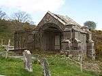 | |||
| Jura Free Church, Largie Breck | 55°52′16″N 5°56′07″W | Category B | 11629 | | |||
| St. Columba's Monastery | 56°13′17″N 5°48′29″W | Category A | 11587 | | |||
| Jura Parish Church, Moine A'Chladaich | 55°50′21″N 5°57′00″W | Category B | 11611 | 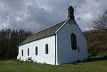 | |||
| Keils-Farmhouse - A Black | 55°50′39″N 5°57′14″W | Category C(S) | 11612 | | |||
| Jura House, Ardfin | 55°48′01″N 6°00′49″W | Category C(S) | 11623 | | |||
| Walled Garden, Jura House Estate | 55°47′59″N 6°00′53″W | Category C(S) | 11624 | | |||
| Feolin Jetty, Feolin | 55°50′54″N 6°05′27″W | Category B | 11628 | | |||
| Bridge, Corran River, Fealin-Lagg Road | 55°52′43″N 5°55′38″W | Category B | 11630 | | |||
| Scarba, Kilmory Lodge | 56°11′21″N 5°41′08″W | Category B | 12383 | | |||
| Lunga Farm-House | 56°12′59″N 5°41′36″W | Category B | 11585 | | |||
| Store-House, Near Lunga Jetty | 56°12′59″N 5°41′31″W | Category C(S) | 11586 | | |||
| Keils - Store/Hut East Of A Keith | 55°50′40″N 5°57′17″W | Category C(S) | 11616 | | |||
| Claig Castle, Am Fraoch Eilean | 55°47′29″N 6°02′07″W | Category C(S) | 11626 | |
Key
The scheme for classifying buildings in Scotland is:
- Category A: "buildings of national or international importance, either architectural or historic; or fine, little-altered examples of some particular period, style or building type."[1]
- Category B: "buildings of regional or more than local importance; or major examples of some particular period, style or building type, which may have been altered."[1]
- Category C: "buildings of local importance; lesser examples of any period, style, or building type, as originally constructed or moderately altered; and simple traditional buildings which group well with other listed buildings."[1]
In March 2016 there were 47,288 listed buildings in Scotland. Of these, 8% were Category A, and 50% were Category B, with the remaining 42% being Category C.[2]
gollark: I mean, on the plus side, money → lasers → yay, but on the... minus side? it's raid shadow legends.
gollark: > I forgot, has styropyro done a raid shadow legends advert before?Sadly, yes.
gollark: Maybe they're doing something cleverer and using this to cover it.
gollark: With access to lots of Twitter accounts I think you might actually be able to... probably significantly influence world politics.
gollark: Cereal company propaganda.
Notes
- Sometimes known as OSGB36, the grid reference (where provided) is based on the British national grid reference system used by the Ordnance Survey.
• "Guide to National Grid". Ordnance Survey. Retrieved 2007-12-12.
• "Get-a-map". Ordnance Survey. Retrieved 2007-12-17. - Historic Environment Scotland assign a unique alphanumeric identifier to each designated site in Scotland, for listed buildings this always begins with "LB", for example "LB12345".
References
- All entries, addresses and coordinates are based on data from Historic Scotland. This data falls under the Open Government Licence
- "What is Listing?". Historic Environment Scotland. Retrieved 29 May 2018.
- Scotland's Historic Environment Audit 2016 (PDF). Historic Environment Scotland and the Built Environment Forum Scotland. pp. 15–16. Retrieved 29 May 2018.
| Settlements |
|  |
|---|---|---|
| Other "non OS settlements" |
| |
| Surrounding islands |
| |
| Other places | ||
This article is issued from Wikipedia. The text is licensed under Creative Commons - Attribution - Sharealike. Additional terms may apply for the media files.