List of listed buildings in Inverkeithing, Fife
List
| Name | Location | Date Listed | Grid Ref. [note 1] | Geo-coordinates | Notes | LB Number [note 2] | Image |
|---|---|---|---|---|---|---|---|
| 1 Bank Street (4, 4A High Street) | 56°01′52″N 3°23′50″W | Category C(S) | 35089 |  | |||
| 2, 4 Bank Street, Thomson's House | 56°01′52″N 3°23′49″W | Category A | 35090 | .jpg) | |||
| 8 Bank Street, Park House Stables | 56°01′51″N 3°23′50″W | Category C(S) | 35092 | | |||
| 10 Bank Street, Park House, Including Garden Terrace, Vaulted Cellars And Boundary Walls | 56°01′50″N 3°23′49″W | Category B | 35093 | | |||
| Commercial Road, Rosebery Doocot | 56°01′50″N 3°23′40″W | Category B | 35108 | | |||
| Dales Farmhouse, Including Boundary Walls And Gatepiers | 56°02′45″N 3°23′23″W | Category B | 13351 | | |||
| Hillend, Spencerfield House Including Gatepiers And Boundary Wall | 56°02′04″N 3°22′52″W | Category B | 12957 | | |||
| Fordell Estate, Crowhill Plantation, Pitadro Doocot | 56°03′15″N 3°22′28″W | Category B | 9982 | | |||
| North Queensferry, 10 Post Office Lane | 56°00′34″N 3°23′37″W | Category C(S) | 9990 | | |||
| North Queensferry, Chapel Place, Clifton House | 56°00′34″N 3°23′39″W | Category B | 9997 | 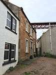 | |||
| North Queensferry, Pierhead, Lantern Tower | 56°00′30″N 3°23′41″W | Category A | 9998 | | |||
| North Queensferry, Pierhead, Signal House, Including Entrance Gates And Boundary Wall | 56°00′29″N 3°23′43″W | Category B | 9999 | 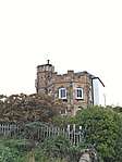 | |||
| North Queensferry, Northcliff, Including Former Laundry, Terraced And Walled Gardens, Gatepiers, Gates And Railings | 56°00′43″N 3°24′00″W | Category B | 47910 | | |||
| North Queensferry, Brock Street, Whinney Knowe, North Queensferry Primary School Including Nursery And Kitchen Block, Playsheds, Boundary Walls, Gatepiers, And Railings | 56°00′43″N 3°23′43″W | Category B | 49038 | | |||
| North Queensferry, Battery Road, Old Jail | 56°00′32″N 3°23′36″W | Category C(S) | 49166 | | |||
| North Queensferry, 4 Ferryhills Road, Carlingnose Farmhouse | 56°00′42″N 3°23′37″W | Category C(S) | 49173 | | |||
| North Queensferry, 12 Main Street, (Davidson's Buildings) | 56°00′34″N 3°23′40″W | Category C(S) | 49177 | | |||
| North Queensferry, Main Street, K6 Telephone Kiosk | 56°00′36″N 3°23′43″W | Category B | 49231 | | |||
| Jamestown, Forth Bridge, North Approach Railway Viaduct | 56°01′23″N 3°24′19″W | Category B | 49652 | | |||
| Church Street, War Memorial | 56°01′55″N 3°23′48″W | Category C(S) | 49941 | | |||
| 1, 3, 5, 7, 9, 11 High Street, Central Bar | 56°01′53″N 3°23′51″W | Category C(S) | 49943 | | |||
| Hillend Road, Inverkeithing High School | 56°02′11″N 3°23′12″W | Category B | 49945 | | |||
| Hope Street, Forth Bridge Approach Railway, Truss Bridge | 56°01′35″N 3°24′10″W | Category B | 49946 | | |||
| Hope Street, St Peter's Episcopal Church Including Boundary Wall | 56°01′29″N 3°24′11″W | Category C(S) | 49948 | | |||
| 9, 9A, 11, 13, 15, 17, 19, 21 (Odd Nos) Townhall Street | 56°01′52″N 3°23′48″W | Category C(S) | 49956 | | |||
| North Queensferry, Railway Pier Including Associated Goods Yard Pier And Disembarkation Pier | 56°00′26″N 3°23′58″W | Category B | 43863 | | |||
| Townhall Street, Town House | 56°01′53″N 3°23′49″W | Category A | 35087 | | |||
| 2 King Street (1 Heriot Street), Including Boundary Walls And Gatepiers | 56°01′54″N 3°23′46″W | Category C(S) | 35107 | | |||
| 79 Hope Street, Viewforth | 56°01′47″N 3°24′11″W | Category B | 35112 | | |||
| Fordell Estate, Pitadro House Including Sundial, Fountain And Gatepiers | 56°03′17″N 3°22′31″W | Category B | 49164 | | |||
| North Queensferry, Main Road, Fernbank, Including Gatepiers, Boundary Walls, Garden Walls And Outbuildings | 56°00′39″N 3°23′59″W | Category C(S) | 49660 | | |||
| Church Street, Standard Lamp | 56°01′58″N 3°23′48″W | Category B | 49940 | | |||
| Inverkeithing Station, Including Timber Fence | 56°02′06″N 3°23′43″W | Category B | 49950 | | |||
| King Street, Bridge Over Keithing Burn | 56°01′54″N 3°23′36″W | Category C(S) | 49951 | | |||
| Roods Road, Inverkeithing Primary Schools, Including Boundary Walls And Playshed | 56°01′57″N 3°23′54″W | Category C(S) | 49955 | | |||
| Bank Street, Mercat Cross | 56°01′51″N 3°23′51″W | Category A | 35088 | 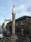 | |||
| 10 High Street (3 Bank Street) | 56°01′51″N 3°23′51″W | Category C(S) | 35094 | | |||
| 13 Heriot Street, Moffat Cottage, Including Summerhouse | 56°01′55″N 3°23′47″W | Category C(S) | 35104 | | |||
| Commercial Road, Bridge Over Keithing Burn | 56°01′49″N 3°23′40″W | Category C(S) | 35109 | | |||
| Old Duloch House, Including Former Stables, Boundary Walls, Gatepiers And Walled Garden | 56°03′15″N 3°23′31″W | Category A | 9981 | | |||
| North Queensferry, 26, 28 Main Street (Black Cat Inn) | 56°00′32″N 3°23′42″W | Category B | 9984 | 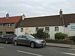 | |||
| North Queensferry, The Brae, Waterloo Well | 56°00′38″N 3°23′41″W | Category B | 9988 | | |||
| North Queensferry, Helen Place, Melinkie Cottage | 56°00′34″N 3°23′35″W | Category C(S) | 9992 | | |||
| North Queensferry, St Margaret's Hope, Gatelodge And Gatepiers | 56°00′52″N 3°24′19″W | Category B | 6406 | | |||
| North Queensferry, Ferry Road, Seabank Cottage Including Boundary Walls | 56°00′36″N 3°23′55″W | Category B | 49171 | | |||
| North Queensferry, 10 Ferryhills Road, Garthill House, Including Boundary Walls And Gatepiers | 56°00′59″N 3°23′36″W | Category B | 49174 | | |||
| North Queensferry, The Brae, Pump And Plaque | 56°00′36″N 3°23′40″W | Category C(S) | 49180 | | |||
| Church Street, Inverkeithing Parish Church (St Peter's Building; Church Of Scotland) Including Churchyard And Boundary Walls | 56°01′54″N 3°23′49″W | Category B | 35086 | 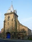 | |||
| Thomson's House Doocot (To Rear Of 2, 4 Bank Street) | 56°01′49″N 3°23′46″W | Category C(S) | 35091 | | |||
| 54, 56 High Street (1 Queen Street) | 56°01′48″N 3°23′55″W | Category C(S) | 35099 | | |||
| 58, 60 Church Street, Inverkeithing Parish Church (St John's Building; Church Of Scotland) Including Adjoining Hall And Offices, Boundary Walls And Railings | 56°02′02″N 3°23′49″W | Category B | 35113 | 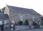 | |||
| North Queensferry, 2 Post Office Lane | 56°00′34″N 3°23′39″W | Category B | 9989 | 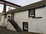 | |||
| North Queensferry, Hill House Including Boundary Wall And Well | 56°00′38″N 3°23′47″W | Category B | 9996 | 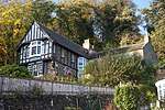 | |||
| North Queensferry, 16 Main Street, Weston House (Davidson's Buildings) | 56°00′33″N 3°23′41″W | Category C(S) | 49178 | | |||
| North Queensferry, Battery Road, East And West Battery Piers Including Shoring And Viewing Area Below Forth Bridge North Cantilever, And Boundary Walls | 56°00′24″N 3°23′26″W | Category A | 43862 | 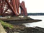 | |||
| 16, 20, 22 High, Street Burgh Arms Hotel | 56°01′50″N 3°23′52″W | Category C(S) | 35097 | | |||
| Queen Street, The Friary Including Well And Vaulted Cellars | 56°01′47″N 3°23′54″W | Category A | 35100 | | |||
| North Queensferry, Main Street, Brae House And White House | 56°00′37″N 3°23′45″W | Category C(S) | 9974 | | |||
| Forth Bridge | 55°59′54″N 3°23′15″W | Category A | 9977 | | |||
| North Queensferry, Town Pier | 56°00′27″N 3°23′43″W | Category A | 9978 | 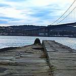 | |||
| North Queensferry, Ferryhills Road, North Queensferry Station Including Fence And Footbridge | 56°00′45″N 3°23′40″W | Category B | 9979 | | |||
| North Queensferry, Battery Road, Royal Naval Signal Station Cottages, Including Gatelodge And Boundary Walls | 56°00′26″N 3°23′24″W | Category B | 9980 | | |||
| North Queensferry, The Brae | 56°00′36″N 3°23′41″W | Category B | 9987 | | |||
| North Queensferry, St Margaret's Hope, Including Boundary Walls, Walled Garden To South And Archway On Drive To North | 56°00′53″N 3°24′29″W | Category B | 6405 | | |||
| Fordell Estate, North West Gate (Off B981) | 56°03′27″N 3°22′56″W | Category C(S) | 49163 | | |||
| North Queensferry, Ferry Road, Craigdhu, Including Boundary Walls And Gatepiers | 56°00′35″N 3°24′07″W | Category B | 49169 | | |||
| 14 Chapel Place, Creggs, Including Boundary Walls And Gatepiers | 56°02′03″N 3°23′50″W | Category C(S) | 49936 | | |||
| 8, 10, 12, 14 Church Street, Queen's Hotel | 56°01′53″N 3°23′51″W | Category C(S) | 49937 | | |||
| Church Street, Inverkeithing Library | 56°01′57″N 3°23′48″W | Category C(S) | 49939 | | |||
| King Street, Railway Bridge And 2 Associated Footbridges Along Line To South | 56°01′54″N 3°23′40″W | Category C(S) | 49952 | | |||
| 23, 25, 27 Townhall Street | 56°01′52″N 3°23′48″W | Category C(S) | 49957 | | |||
| 12, 14, 18 High Street, Providence House | 56°01′50″N 3°23′51″W | Category B | 35096 | | |||
| North Queensferry, 25 Main Street, Albert Hotel | 56°00′31″N 3°23′40″W | Category C(S) | 9975 | 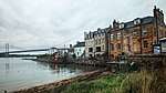 | |||
| Hillend, 37, 39 Main Street, Hillend Tavern | 56°02′27″N 3°22′23″W | Category C(S) | 9983 | | |||
| North Queensferry, Main Street, Pierhead House | 56°00′30″N 3°23′41″W | Category C(S) | 47553 | | |||
| North Queensferry, 4, 6 Post Office Lane | 56°00′34″N 3°23′38″W | Category C(S) | 49179 | | |||
| Boreland Road, Bridge Over Keithing Burn, Halbeath Waggon Way And Railway | 56°02′02″N 3°23′42″W | Category B | 49935 | | |||
| Inverkeithing Harbour | 56°01′42″N 3°23′42″W | Category B | 49949 | | |||
| 35, 37 High Street, Royal Bank Of Scotland | 56°01′51″N 3°23′54″W | Category C(S) | 35101 | | |||
| 16, 18 Church Street, Fordell's Lodging | 56°01′54″N 3°23′51″W | Category A | 35103 | 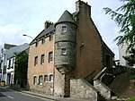 | |||
| 2 Hope Street, (Old Corn Exchange) Including Terrace | 56°01′45″N 3°23′58″W | Category B | 35110 | | |||
| 54 Hope Street (Old Parish Manse) Including Boundary Walls, Gatepiers And Garden Steps | 56°01′36″N 3°24′08″W | Category C(S) | 35111 | | |||
| North Queensferry, Helen Place, Heron House | 56°00′34″N 3°23′36″W | Category C(S) | 9993 | | |||
| Fordell Estate, Fordell Nursery, Walled Garden | 56°03′14″N 3°22′32″W | Category B | 49162 | | |||
| North Queensferry, Chapel Place, Fourteen Falls Including Boundary Walls | 56°00′33″N 3°23′37″W | Category C(S) | 49168 | | |||
| North Queensferry, Ferry Road, Ferrycraigs House | 56°00′40″N 3°24′16″W | Category C(S) | 49170 | | |||
| North Queensferry, Main Street, Willie's Well | 56°00′36″N 3°23′44″W | Category B | 49175 | | |||
| Hope Street, K6 Telephone Kiosk | 56°01′34″N 3°24′10″W | Category B | 49947 | | |||
| Port Street, Vennel Wall | 56°01′51″N 3°23′44″W | Category C(S) | 49953 | | |||
| Jamestown, Ferryhills Road, Naval Base Mansions | 56°01′22″N 3°24′12″W | Category B | 51009 | | |||
| 6, 8 High Street | 56°01′52″N 3°23′51″W | Category C(S) | 35095 | | |||
| 34, 36, 38, 40 High Street | 56°01′49″N 3°23′52″W | Category C(S) | 35098 | | |||
| 79, 81 High Street, Including Wash House And Boundary Walls | 56°01′48″N 3°23′57″W | Category B | 35102 | | |||
| 9 King Street, Rosebery House, Including Well, Marriage Lintel To Back Garden, Boundary Walls And Gatepiers | 56°01′53″N 3°23′45″W | Category B | 35106 | | |||
| North Queensferry, 18 Main Street, Ivy Cottage | 56°00′33″N 3°23′40″W | Category C(S) | 9976 | | |||
| North Queensferry, 10, 14 Main Street, (Davidson's Buildings) | 56°00′33″N 3°23′41″W | Category B | 9985 |  | |||
| North Queensferry, The Brae, Old School House | 56°00′38″N 3°23′40″W | Category C(S) | 9986 | | |||
| North Queensferry, Helen Place, Helen Cottage | 56°00′34″N 3°23′37″W | Category C(S) | 9994 | | |||
| Forth Road Bridge, Including Approach Ramps And Piers | 56°00′06″N 3°24′15″W | Category A | 49165 | 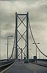 | |||
| North Queensferry, Carlingnose Submarine Mining Pier | 56°00′47″N 3°23′13″W | Category B | 49167 | | |||
| North Queensferry, 17 Ferryhills Road, Ierne | 56°00′52″N 3°23′37″W | Category C(S) | 49172 | | |||
| Roman Road, Town Wall | 56°01′49″N 3°24′01″W | Category C(S) | 49954 | |
Key
The scheme for classifying buildings in Scotland is:
- Category A: "buildings of national or international importance, either architectural or historic; or fine, little-altered examples of some particular period, style or building type."[1]
- Category B: "buildings of regional or more than local importance; or major examples of some particular period, style or building type, which may have been altered."[1]
- Category C: "buildings of local importance; lesser examples of any period, style, or building type, as originally constructed or moderately altered; and simple traditional buildings which group well with other listed buildings."[1]
In March 2016 there were 47,288 listed buildings in Scotland. Of these, 8% were Category A, and 50% were Category B, with the remaining 42% being Category C.[2]
gollark: It's not generally well-defined but sophont generally means at least "agenty" right?
gollark: This seems like a weird example for worrying about automation, given that they are using them to train existing pilots, and warplane pilot is not exactly a common job.
gollark: There's no reason you couldn't make the AI do that optimisation too.
gollark: Hi. Your profile picture is quite cool.
gollark: Or that.
See also
Notes
- Sometimes known as OSGB36, the grid reference (where provided) is based on the British national grid reference system used by the Ordnance Survey.
• "Guide to National Grid". Ordnance Survey. Retrieved 2007-12-12.
• "Get-a-map". Ordnance Survey. Retrieved 2007-12-17. - Historic Environment Scotland assign a unique alphanumeric identifier to each designated site in Scotland, for listed buildings this always begins with "LB", for example "LB12345".
References
- All entries, addresses and coordinates are based on data from Historic Scotland. This data falls under the Open Government Licence
- "What is Listing?". Historic Environment Scotland. Retrieved 29 May 2018.
- Scotland's Historic Environment Audit 2016 (PDF). Historic Environment Scotland and the Built Environment Forum Scotland. pp. 15–16. Retrieved 29 May 2018.
This article is issued from Wikipedia. The text is licensed under Creative Commons - Attribution - Sharealike. Additional terms may apply for the media files.