List of listed buildings in Inverkeilor, Angus
List
| Name | Location | Date Listed | Grid Ref. [note 1] | Geo-coordinates | Notes | LB Number [note 2] | Image |
|---|---|---|---|---|---|---|---|
| Ethie Castle | 56°36′45″N 2°30′39″W | Category A | 11278 |  | |||
| Lunan Bank House | 56°37′29″N 2°34′46″W | Category B | 11286 | | |||
| Lawton House Including Hencote And Steading | 56°37′38″N 2°35′34″W | Category B | 11287 | | |||
| Leysmill, Main Street Cottages | 56°37′08″N 2°38′46″W | Category C(S) | 11293 | | |||
| St. Murdoch's Chapel | 56°37′21″N 2°29′07″W | Category B | 11283 | 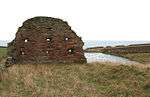 | |||
| Boysack Mill Bridge Over Lunan Water | 56°37′57″N 2°36′50″W | Category B | 11292 | 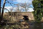 | |||
| Leysmill Farmhouse | 56°37′14″N 2°38′49″W | Category C(S) | 11294 | | |||
| "Rowan Cottage", Inverkeilor | 56°38′03″N 2°32′48″W | Category C(S) | 11301 | | |||
| Hilton Farmhouse | 56°38′43″N 2°33′23″W | Category B | 11272 | | |||
| Ethie - Walled Garden | 56°36′46″N 2°30′36″W | Category B | 11279 | | |||
| Abbeythune House - North Lodge | 56°37′40″N 2°33′02″W | Category C(S) | 11284 | | |||
| Old Kinblethmont | 56°36′48″N 2°35′31″W | Category B | 11288 | | |||
| Boysack Mill | 56°37′57″N 2°36′49″W | Category B | 11290 | | |||
| Leysmill, K6 Telephone Kiosk | 56°37′09″N 2°38′43″W | Category B | 13078 | | |||
| Marywell Bridge Over Lunan Water | 56°37′57″N 2°33′10″W | Category B | 11302 | | |||
| Anniston Mill | 56°37′37″N 2°31′25″W | Category C(S) | 11276 | | |||
| Raesmill Farmhouse | 56°37′17″N 2°31′16″W | Category C(S) | 11277 | | |||
| Inverkeilor Parish Kirk | 56°38′13″N 2°32′54″W | Category C(S) | 11295 | 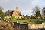 | |||
| Kirkton Mill Bridge Over Lunan Water | 56°38′09″N 2°33′53″W | Category B | 11270 | 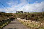 | |||
| Cotton Of Inchock - Farm Cottage | 56°37′30″N 2°31′42″W | Category C(S) | 11275 | | |||
| Ethie - Barns | 56°36′49″N 2°30′20″W | Category C(S) | 11282 | | |||
| Boysack Miller's House | 56°37′56″N 2°36′36″W | Category B | 11291 | | |||
| Northesk Burial Aisle | 56°38′13″N 2°32′54″W | Category B | 11296 | | |||
| Old Kirkton Mill | 56°38′04″N 2°33′42″W | Category C(S) | 11269 | | |||
| Red Castle - Keep | 56°39′02″N 2°30′39″W | Category A | 11274 | 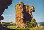 | |||
| Chapelton Burial Place | 56°37′14″N 2°36′47″W | Category C(S) | 11289 | | |||
| Rait Mural Monument, Parish Kirkyard | 56°38′14″N 2°32′55″W | Category B | 11297 | | |||
| Parish Kirk Manse | 56°38′11″N 2°32′53″W | Category C(S) | 11299 | | |||
| Red Castle - Enceinte | 56°39′02″N 2°30′39″W | Category A | 11273 | 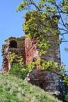 | |||
| Balmullie Mill - Bridge Over Lunan Water | 56°37′43″N 2°34′35″W | Category C(S) | 11285 |  | |||
| Balmullie Mill | 56°37′43″N 2°34′33″W | Category C(S) | 13746 | 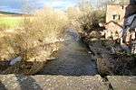 | |||
| Carnegie Mural Monument, Parish Kirkyard | 56°38′14″N 2°32′55″W | Category C(S) | 11298 | | |||
| Kirkton Farm Building | 56°38′10″N 2°32′48″W | Category C(S) | 11300 | | |||
| Grange House | 56°38′13″N 2°33′42″W | Category C(S) | 11271 | | |||
| Ethie - Garden Storehouse | 56°36′43″N 2°30′30″W | Category B | 11280 | | |||
| Ethie - Garden - House | 56°36′43″N 2°30′35″W | Category C(S) | 11281 | |
Key
The scheme for classifying buildings in Scotland is:
- Category A: "buildings of national or international importance, either architectural or historic; or fine, little-altered examples of some particular period, style or building type."[1]
- Category B: "buildings of regional or more than local importance; or major examples of some particular period, style or building type, which may have been altered."[1]
- Category C: "buildings of local importance; lesser examples of any period, style, or building type, as originally constructed or moderately altered; and simple traditional buildings which group well with other listed buildings."[1]
In March 2016 there were 47,288 listed buildings in Scotland. Of these, 8% were Category A, and 50% were Category B, with the remaining 42% being Category C.[2]
gollark: #8 as *citrons*? Really?
gollark: <@356107472269869058> make macron.
gollark: <@319753218592866315>
gollark: According to my random number generator, I should now be making some quip about #5.
gollark: Oh yes, I don't really like manually managing memory.
See also
Notes
- Sometimes known as OSGB36, the grid reference (where provided) is based on the British national grid reference system used by the Ordnance Survey.
• "Guide to National Grid". Ordnance Survey. Retrieved 2007-12-12.
• "Get-a-map". Ordnance Survey. Retrieved 2007-12-17. - Historic Environment Scotland assign a unique alphanumeric identifier to each designated site in Scotland, for listed buildings this always begins with "LB", for example "LB12345".
References
- All entries, addresses and coordinates are based on data from Historic Scotland. This data falls under the Open Government Licence
- "What is Listing?". Historic Environment Scotland. Retrieved 29 May 2018.
- Scotland's Historic Environment Audit 2016 (PDF). Historic Environment Scotland and the Built Environment Forum Scotland. pp. 15–16. Retrieved 29 May 2018.
This article is issued from Wikipedia. The text is licensed under Creative Commons - Attribution - Sharealike. Additional terms may apply for the media files.