List of listed buildings in Inverarity, Angus
List
| Name | Location | Date Listed | Grid Ref. [note 1] | Geo-coordinates | Notes | LB Number [note 2] | Image |
|---|---|---|---|---|---|---|---|
| Fothringham - Bridge Over Kerbet Burn | 56°35′01″N 2°53′02″W | Category C(S) | 10999 |  | |||
| Fothringham-Ice-House | 56°34′42″N 2°52′54″W | Category C(S) | 11000 | | |||
| Meathie Graveyard | 56°36′18″N 2°52′21″W | Category B | 11003 | | |||
| Loanfoot Cottages 2, Kincaldrum | 56°35′19″N 2°55′24″W | Category B | 11007 | | |||
| Fothringham - South Lodge | 56°34′35″N 2°52′47″W | Category B | 10992 | | |||
| Fothringham House | 56°35′24″N 2°52′37″W | Category C(S) | 10995 | | |||
| Holemill - Old Corn Mill | 56°35′33″N 3°02′35″W | Category B | 11008 | | |||
| Inverarity Parish Kirk | 56°35′16″N 2°53′33″W | Category B | 10993 | 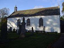 | |||
| Parish Kirk Manse | 56°35′22″N 2°53′38″W | Category B | 10994 | | |||
| Fothringham - Doocot | 56°35′08″N 2°53′01″W | Category B | 10997 | 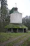 | |||
| Easter Meathie - Sundial | 56°36′30″N 2°52′29″W | Category C(S) | 11004 | | |||
| Kincaldrum House Doocot | 56°35′35″N 2°55′36″W | Category B | 11005 | | |||
| Holemill Bridge Over Kerbet Burn | 56°34′56″N 2°50′38″W | Category B | 10988 | | |||
| Fothringham Stables | 56°35′07″N 2°52′57″W | Category C(S) | 10996 | | |||
| Fothringham - Home Farm Cottages | 56°35′17″N 2°52′58″W | Category C(S) | 10998 | | |||
| Old Invereighty Bridge Over Kerbet Water | 56°35′44″N 2°54′36″W | Category C(S) | 11001 | 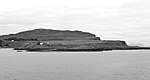 | |||
| Meathie Church (On Easter Meathie Farm) | 56°36′18″N 2°52′21″W | Category B | 11002 | | |||
| Loanfoot Cottages 1, Kincaldrum | 56°35′19″N 2°55′25″W | Category B | 11006 | | |||
| Kirkbuddo Old Graveyard | 56°34′43″N 2°49′35″W | Category C(S) | 10989 | | |||
| Fothringham-Mid-Lodge | 56°35′14″N 2°53′07″W | Category B | 10990 | 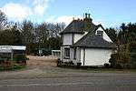 | |||
| "The Hostel" South Tarbrax | 56°33′39″N 2°55′36″W | Category B | 10991 | |
Key
The scheme for classifying buildings in Scotland is:
- Category A: "buildings of national or international importance, either architectural or historic; or fine, little-altered examples of some particular period, style or building type."[1]
- Category B: "buildings of regional or more than local importance; or major examples of some particular period, style or building type, which may have been altered."[1]
- Category C: "buildings of local importance; lesser examples of any period, style, or building type, as originally constructed or moderately altered; and simple traditional buildings which group well with other listed buildings."[1]
In March 2016 there were 47,288 listed buildings in Scotland. Of these, 8% were Category A, and 50% were Category B, with the remaining 42% being Category C.[2]
gollark: Or just don't because the OS will do it!
gollark: Store all new `malloc`ed pointers in a linked list, then free everything in the linked list at the end, then free the linked list.
gollark: Or just free everything at the end.
gollark: Do that, then. For performance.
gollark: You only lost 31, which is 10^-8 or so of that, so you can ignore it.
See also
Notes
- Sometimes known as OSGB36, the grid reference (where provided) is based on the British national grid reference system used by the Ordnance Survey.
• "Guide to National Grid". Ordnance Survey. Retrieved 2007-12-12.
• "Get-a-map". Ordnance Survey. Retrieved 2007-12-17. - Historic Environment Scotland assign a unique alphanumeric identifier to each designated site in Scotland, for listed buildings this always begins with "LB", for example "LB12345".
References
- All entries, addresses and coordinates are based on data from Historic Scotland. This data falls under the Open Government Licence
- "What is Listing?". Historic Environment Scotland. Retrieved 29 May 2018.
- Scotland's Historic Environment Audit 2016 (PDF). Historic Environment Scotland and the Built Environment Forum Scotland. pp. 15–16. Retrieved 29 May 2018.
This article is issued from Wikipedia. The text is licensed under Creative Commons - Attribution - Sharealike. Additional terms may apply for the media files.