List of listed buildings in Haddington, East Lothian
List
| Name | Location | Date Listed | Grid Ref. [note 1] | Geo-coordinates | Notes | LB Number [note 2] | Image |
|---|---|---|---|---|---|---|---|
| Westfield Cottages Nos 3 To 6 | 55°55′59″N 2°48′19″W | Category C(S) | 43562 |  | |||
| Abbey, Old School And Adjacent Buildings | 55°57′46″N 2°44′57″W | Category B | 43523 | | |||
| Camptoun Steading, Cartshed And Granary | 55°59′26″N 2°48′07″W | Category C(S) | 43537 | | |||
| Lennoxlove Acredales, With Gateway | 55°56′55″N 2°46′24″W | Category C(S) | 43545 | | |||
| Lennoxlove House, South Lodge | 55°55′59″N 2°47′04″W | Category C(S) | 43550 | | |||
| Sandersdean, Former Cottages Now Outbuilding | 55°56′11″N 2°44′49″W | Category B | 43555 | | |||
| Stevenson House Walled Garden, Trust Cottage And Gardeners Cottage | 55°57′53″N 2°43′44″W | Category C(S) | 43558 | | |||
| Greenknowe Coatfield (Off Dunbar Road) | 55°57′39″N 2°46′39″W | Category B | 34469 | | |||
| Buildings At Rear Of Garage, Hardgate | 55°57′20″N 2°46′31″W | Category C(S) | 34350 | | |||
| 3, 4 The Sands | 55°57′16″N 2°46′24″W | Category B | 34364 | | |||
| 1, 2 Sidegate | 55°57′18″N 2°46′30″W | Category B | 34367 | | |||
| Building At Rear Of 7 Sidegate | 55°57′18″N 2°46′31″W | Category B | 34370 | | |||
| 13, 15 Sidegate | 55°57′15″N 2°46′30″W | Category B | 34374 | | |||
| 17, 18, 19 Sidegate | 55°57′15″N 2°46′29″W | Category C(S) | 34375 | | |||
| Newburn Lodge 22 Sidegate | 55°57′13″N 2°46′29″W | Category C(S) | 34378 | | |||
| 2-7 St Ann's Place | 55°57′17″N 2°46′27″W | Category B | 34383 | | |||
| Garden Walls And Gatepiers Haddington House Sidegate | 55°57′14″N 2°46′25″W | Category B | 34390 | | |||
| 7, 8 Poldrate | 55°57′08″N 2°46′27″W | Category C(S) | 34406 | | |||
| West Mills Cottage Distillery Park | 55°57′03″N 2°46′53″W | Category B | 34411 | | |||
| Tynebank Tynebank Road | 55°57′04″N 2°47′04″W | Category B | 34413 | | |||
| Cumming's Buildings Waterside | 55°57′17″N 2°46′15″W | Category C(S) | 34421 | | |||
| Gimmersmill House, Gimmers Mill Now Offices For Bermaline Mills | 55°57′25″N 2°46′24″W | Category B | 34427 | | |||
| Knox House Newton Port | 55°57′12″N 2°46′13″W | Category C(S) | 34447 | | |||
| Knox Institute Knox Place | 55°57′16″N 2°47′06″W | Category B | 34451 | | |||
| Mansefield Station Road West End | 55°57′21″N 2°47′05″W | Category B | 34456 | | |||
| Building At Rear Of 1, 2 Lodge Street | 55°57′18″N 2°46′43″W | Category B | 34247 | | |||
| Buildings Peffer's Place | 55°57′16″N 2°46′50″W | Category C(S) | 34259 | | |||
| Buildings, Brewery Park Lane Court Street | 55°57′19″N 2°46′53″W | Category C(S) | 34263 | | |||
| 39, 41 Court Street Police Station | 55°57′19″N 2°46′56″W | Category B | 34269 | | |||
| 51, 53 Court Street | 55°57′19″N 2°47′00″W | Category C(S) | 34270 | | |||
| 59 Court Street | 55°57′19″N 2°47′01″W | Category B | 34272 | | |||
| 20, 22 Court Street | 55°57′21″N 2°46′47″W | Category B | 34288 | | |||
| 42, 43, 44 Market Street | 55°57′21″N 2°46′43″W | Category B | 34296 | | |||
| 37, 38 Market St | 55°57′21″N 2°46′42″W | Category B | 34298 | | |||
| 31, 32, 33 Market Street | 55°57′21″N 2°46′40″W | Category B | 34300 | | |||
| 13 Market Street | 55°57′22″N 2°46′35″W | Category B | 34312 | | |||
| Old Evangelical Union Church, Off Market Street, (Now Used By British Legion) | 55°57′23″N 2°46′34″W | Category B | 34314 | | |||
| 5, 6 Market Street | 55°57′22″N 2°46′32″W | Category B | 34316 | | |||
| 70 Market Street Crown Dairy | 55°57′20″N 2°46′35″W | Category B | 34324 | | |||
| 52, 53 Market St | 55°57′20″N 2°46′42″W | Category C(S) | 34334 | | |||
| 68 High Street | 55°57′20″N 2°46′38″W | Category B | 34191 | | |||
| 80, 81 High Street | 55°57′20″N 2°46′35″W | Category B | 34199 | | |||
| 82, 83, 84, High Street | 55°57′20″N 2°46′34″W | Category B | 34200 | | |||
| 85, 86, 87 High Street | 55°57′20″N 2°46′34″W | Category B | 34201 | | |||
| 90 High Street | 55°57′20″N 2°46′33″W | Category B | 34203 | | |||
| 5, 6, 7 High Street | 55°57′18″N 2°46′31″W | Category B | 34208 | | |||
| 9 High Street | 55°57′19″N 2°46′32″W | Category B | 34210 | | |||
| Mungoswells, With Garden Walls | 56°00′00″N 2°48′33″W | Category B | 13205 | | |||
| Letham House, With Pavilions, Gatepiers And Glasshouse | 55°57′01″N 2°48′45″W | Category B | 10813 | | |||
| Stevenson House, With Garden Statuary And Gates | 55°57′51″N 2°43′52″W | Category A | 10821 | | |||
| Amisfield Park, Ice House | 55°57′36″N 2°45′24″W | Category C(S) | 10828 | | |||
| Hopetoun Monument | 55°58′42″N 2°48′06″W | Category B | 10831 | | |||
| Alderston House, With Icehouse | 55°57′40″N 2°48′12″W | Category B | 10834 | | |||
| Garlton Unit, (Admissions Unit) Hermandflat Hospital, Aberlady Road, Haddington And Including Boundary Walls | 55°57′37″N 2°47′17″W | Category B | 50860 | | |||
| Abbey Mill | 55°57′44″N 2°44′50″W | Category B | 43524 | | |||
| Abbey Mill Farm | 55°57′47″N 2°44′54″W | Category B | 43525 | | |||
| Amisfield Mains Farmhouse | 55°58′09″N 2°45′37″W | Category C(S) | 43528 | | |||
| Camptoun House, With Coach House, Stables And Walled Garden | 55°59′21″N 2°48′03″W | Category B | 43535 | | |||
| Colstoun, Front Lodge Bridge To Main Drive | 55°55′57″N 2°46′44″W | Category B | 43540 | | |||
| Monkrigg Farmhouse | 55°56′39″N 2°45′46″W | Category B | 43553 | | |||
| Lochinvar 1 West Road | 55°57′20″N 2°47′26″W | Category B | 34463 | | |||
| Hatchery Cottage West Road | 55°57′14″N 2°47′56″W | Category C(S) | 34466 | | |||
| Garage, Hardgate | 55°57′21″N 2°46′31″W | Category C(S) | 34349 | | |||
| 21 Sidegate, The Old Manse, (Formerly Church Of Scotland Manse) | 55°57′13″N 2°46′32″W | Category B | 34377 | | |||
| Gighouse, At South-East Of Lodge, St Mary's Parish Church | 55°57′10″N 2°46′26″W | Category C(S) | 34395 | | |||
| Presbytery Poldrate | 55°57′10″N 2°46′26″W | Category C(S) | 34396 | | |||
| Tyne House Hotel Poldrate | 55°57′06″N 2°46′28″W | Category B | 34400 | | |||
| Millfield And Outbuildings, Millwynd | 55°57′06″N 2°46′48″W | Category C(S) | 34407 | | |||
| Row Of Buildings At West Entrance To Haddington Maltings | 55°57′03″N 2°46′50″W | Category C(S) | 34409 | | |||
| Nungate Bridge Bridge Street | 55°57′17″N 2°46′18″W | Category A | 34414 | 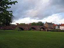 | |||
| House And Store 19 Bridge Street | 55°57′18″N 2°46′13″W | Category C(S) | 34416 | | |||
| Derelict House Waterside | 55°57′16″N 2°46′15″W | Category C(S) | 34420 | | |||
| The Elms Dunbar Road | 55°57′33″N 2°46′37″W | Category B | 34431 | | |||
| Library And Museum Newton Port | 55°57′24″N 2°46′40″W | Category C(S) | 34446 | | |||
| Chestnut Cottage Knox Place | 55°57′18″N 2°47′03″W | Category C(S) | 34450 | | |||
| Fonab, Station Road West End | 55°57′21″N 2°47′07″W | Category B | 34457 | | |||
| Maryville Station Road West End | 55°57′22″N 2°47′15″W | Category B | 34460 | | |||
| Crocegate Dovecot To Rear Of 43, 45 High Street | 55°57′15″N 2°46′38″W | Category B | 34236 | | |||
| 47 High Street | 55°57′19″N 2°46′41″W | Category B | 34237 | | |||
| House At Rear Of 50, 51 High Street | 55°57′18″N 2°46′42″W | Category B | 34240 | | |||
| 52 High Street. City Bank Building | 55°57′19″N 2°46′43″W | Category B | 34241 | | |||
| Beaconsfield Paterson Place | 55°57′16″N 2°46′44″W | Category B | 34251 | | |||
| Victoria Inn 3, 5, 7 Court Street And 12 Lodge Street | 55°57′19″N 2°46′47″W | Category B | 34255 | | |||
| House, Brewery Park Lane, Court Street | 55°57′19″N 2°46′53″W | Category C(S) | 34262 | | |||
| Buildings 2 Brewery Park Lane Court Street | 55°57′16″N 2°46′53″W | Category C(S) | 34264 | | |||
| 36, 38 Court Street Edinburgh Savings Bank | 55°57′20″N 2°46′51″W | Category C(S) | 34283 | | |||
| 24 Court Street | 55°57′21″N 2°46′48″W | Category B | 34287 | | |||
| 20 Market Street Courier Printing Works | 55°57′22″N 2°46′37″W | Category B | 34308 | | |||
| Black Bull Hotel Block 73 Market Street | 55°57′21″N 2°46′33″W | Category B | 34321 | | |||
| Warehouse Kilpair Street At Rear Of 77 Market Street | 55°57′21″N 2°46′33″W | Category C(S) | 34336 | | |||
| 4, 5 Hardgate | 55°57′20″N 2°46′29″W | Category B | 34340 | | |||
| Bothwell Bank, Hardgate | 55°57′25″N 2°46′30″W | Category B | 34346 | | |||
| 61, 62, 63 High Street | 55°57′20″N 2°46′41″W | Category B | 34188 | | |||
| 66, 67 High Street | 55°57′20″N 2°46′40″W | Category B | 34190 | | |||
| Building At Rear Of 19, 20 High Street | 55°57′18″N 2°46′34″W | Category B | 34220 | | |||
| Begbie Steading | 55°55′40″N 2°48′53″W | Category B | 13202 | | |||
| Amisfield Mains, Gothic Barn | 55°58′10″N 2°45′34″W | Category C(S) | 13204 | | |||
| Lennoxlove House Or Lethington | 55°56′20″N 2°46′40″W | Category A | 10814 | | |||
| Colstoun House, With Garden Statuary | 55°55′46″N 2°46′37″W | Category B | 10816 |  | |||
| West Bearford Steading | 55°56′56″N 2°43′40″W | Category B | 10830 | | |||
| Huntington House, With Walled Garden | 55°57′47″N 2°49′28″W | Category A | 10832 | | |||
| Florabank Road, Templedean House And West Templedean Including Boundary Walls And Gatepiers | 55°57′37″N 2°46′52″W | Category C(S) | 49904 | | |||
| Amisfield Park Weir Or Cascade | 55°57′38″N 2°45′23″W | Category C(S) | 43530 | | |||
| Grant's Braes Bridge | 55°56′15″N 2°47′33″W | Category B | 43543 | | |||
| Lennoxlove House, Boundary Walls | 55°56′20″N 2°46′40″W | Category B | 43546 | | |||
| Lennoxlove House, North Lodge And North Port | 55°56′40″N 2°46′56″W | Category B | 43549 | | |||
| 57 Hardgate St John Kilwinning Lodge | 55°57′21″N 2°46′30″W | Category C(S) | 34348 | | |||
| 18 Church Street | 55°57′17″N 2°46′27″W | Category B | 34353 | | |||
| Tyne Lodge 9 The Sands | 55°57′16″N 2°46′23″W | Category B | 34366 | | |||
| Holmsdale 11 Sidegate | 55°57′16″N 2°46′30″W | Category B | 34373 | | |||
| 33,35 Sidegate | 55°57′16″N 2°46′29″W | Category B | 34385 | | |||
| St Mary's Parish Church And Churchyard Including Boundary Walls, Gatepiers And Gates | 55°57′12″N 2°46′19″W | Category A | 34391 | | |||
| Garden Walls And Gatepiers Lady Kitty's Garden | 55°57′15″N 2°46′21″W | Category B | 34392 | | |||
| Lodge St Mary's Parish Church | 55°57′11″N 2°46′26″W | Category C(S) | 34394 | | |||
| Granary Ford Road | 55°57′16″N 2°46′11″W | Category C(S) | 34418 | | |||
| Spancilhill St Martin's Gate | 55°57′22″N 2°46′11″W | Category C(S) | 34424 | | |||
| Bermaline Maltings Whittingehame Drive | 55°57′24″N 2°46′21″W | Category C(S) | 34429 | | |||
| Ivybank Dunbar Road | 55°57′33″N 2°46′38″W | Category C(S) | 34432 | | |||
| 43, 44, 45 High Street | 55°57′19″N 2°46′40″W | Category B | 34234 | | |||
| Primrose Bank Entering At 3 Lodge Street | 55°57′16″N 2°46′43″W | Category B | 34249 | | |||
| 35 Court Street Weston Nurseries | 55°57′18″N 2°46′55″W | Category C(S) | 34268 | | |||
| Railway Hotel Court Street | 55°57′20″N 2°47′01″W | Category C(S) | 34274 | | |||
| 34 Court Street | 55°57′21″N 2°46′50″W | Category B | 34284 | | |||
| 22 Market Street | 55°57′21″N 2°46′38″W | Category B | 34307 | | |||
| 18 Market Street | 55°57′22″N 2°46′36″W | Category B | 34309 | | |||
| Town Hall | 55°57′20″N 2°46′43″W | Category A | 34185 | | |||
| 1 High Street | 55°57′19″N 2°46′30″W | Category B | 34206 | | |||
| 15 High Street | 55°57′19″N 2°46′33″W | Category B | 34216 | | |||
| 17, 18 High Street | 55°57′19″N 2°46′34″W | Category B | 34218 | | |||
| 21, 22 High Street | 55°57′19″N 2°46′35″W | Category B | 34221 | | |||
| 29, 30, 31 High Street | 55°57′19″N 2°46′36″W | Category B | 34226 | | |||
| 33, 34 High Street | 55°57′19″N 2°46′37″W | Category B | 34230 | | |||
| Amisfield Park, West Gates With Amisfield Cottage And West Lodge | 55°57′19″N 2°45′54″W | Category B | 10818 | | |||
| Amisfield House Stables | 55°57′32″N 2°45′20″W | Category B | 10819 | | |||
| Barnes Castle Or Barney Vaults | 55°58′47″N 2°45′25″W | Category B | 10823 | | |||
| Amisfield Park Walled Garden | 55°57′30″N 2°44′58″W | Category A | 10825 | 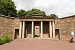 | |||
| Colstoun Bridge | 55°55′59″N 2°46′42″W | Category B | 6391 | | |||
| Amisfield Park, Ha-Ha | 55°57′27″N 2°44′54″W | Category B | 46708 | | |||
| Amisfield Park, Corby Well | 55°57′50″N 2°45′10″W | Category C(S) | 47924 | | |||
| Aberlady Road, Herdmanflatt Hospital, North Lodge | 55°57′36″N 2°47′16″W | Category C(S) | 48294 | | |||
| Westfield Steading | 55°55′59″N 2°48′09″W | Category B | 43564 | | |||
| Woodside | 55°56′58″N 2°51′27″W | Category B | 43565 | | |||
| Amisfield Cottages Or Bluehouses | 55°57′59″N 2°45′24″W | Category C(S) | 43526 | | |||
| Begbie Farmhouse, With Gatepiers | 55°55′39″N 2°48′54″W | Category C(S) | 43532 | | |||
| Clerkington House Stables With Walled Garden | 55°56′39″N 2°47′28″W | Category B | 43538 | | |||
| Lennoxlove House, East Port And Lodge | 55°56′43″N 2°46′15″W | Category B | 43547 | | |||
| Lennoxlove House, Garden Gateway | 55°56′20″N 2°46′39″W | Category A | 43548 | | |||
| Ugston Farmhouse | 55°57′45″N 2°48′48″W | Category C(S) | 43559 | | |||
| Westfield Cottages, No 1 And 2 | 55°56′00″N 2°48′14″W | Category C(S) | 43561 | | |||
| Old Bank House, 43 Hardgate | 55°57′27″N 2°46′34″W | Category B | 34347 | | |||
| 9, 10, 11, 12 Church Street | 55°57′18″N 2°46′24″W | Category B | 34351 | | |||
| 3 Church Street | 55°57′19″N 2°46′29″W | Category B | 34356 | | |||
| Elm House Church Street | 55°57′18″N 2°46′23″W | Category B | 34361 | | |||
| 1 The Sands | 55°57′17″N 2°46′24″W | Category B | 34362 | | |||
| 6, 7 Sidegate | 55°57′18″N 2°46′30″W | Category B | 34369 | | |||
| 8 And 8A Sidegate | 55°57′17″N 2°46′30″W | Category B | 34371 | | |||
| 10 Sidegate | 55°57′16″N 2°46′30″W | Category B | 34372 | | |||
| Granary Poldrate | 55°57′07″N 2°46′27″W | Category B | 34402 | | |||
| House Ford Road | 55°57′16″N 2°46′15″W | Category C(S) | 34419 | | |||
| Goatfield Toll House 31 Dunbar Road | 55°57′38″N 2°46′36″W | Category C(S) | 34435 | | |||
| 3/4 Newton Port East Lothian Courier Warehouse | 55°57′22″N 2°46′37″W | Category B | 34436 | | |||
| St John's Church Newton Port | 55°57′26″N 2°46′44″W | Category B | 34444 | | |||
| Dale House Off Newton Port | 55°57′25″N 2°46′44″W | Category B | 34445 | | |||
| Cottage Adjoining Monument Knox Place | 55°57′19″N 2°47′04″W | Category C(S) | 34449 | | |||
| Parkside Cottages Station Road West End | 55°57′20″N 2°47′08″W | Category B | 34458 | | |||
| Bellevue Station Road West End | 55°57′22″N 2°47′18″W | Category B | 34461 | | |||
| Park View Paterson Place | 55°57′13″N 2°46′43″W | Category B | 34252 | | |||
| 1-6 Peffer's Place | 55°57′16″N 2°46′49″W | Category C(S) | 34258 | | |||
| 31 Court Street | 55°57′18″N 2°46′54″W | Category B | 34266 | | |||
| 1 Hope Street Part Of Railway Hotel Court Street | 55°57′20″N 2°47′01″W | Category C(S) | 34273 | | |||
| 26 Court Street | 55°57′21″N 2°46′48″W | Category B | 34286 | | |||
| 16, 18 Court Street | 55°57′21″N 2°46′46″W | Category B | 34289 | | |||
| 10-14 Court Street | 55°57′21″N 2°46′46″W | Category C(S) | 34290 | | |||
| Tweeddale Monument, Court Street | 55°57′19″N 2°46′51″W | Category B | 34292 | | |||
| 47, 48, 49 Market Street | 55°57′21″N 2°46′44″W | Category B | 34294 | | |||
| 24, 25 Market St | 55°57′21″N 2°46′38″W | Category A | 34306 | | |||
| 2, 3 Market Street | 55°57′23″N 2°46′32″W | Category B | 34318 | | |||
| 71 Market Street | 55°57′20″N 2°46′35″W | Category B | 34323 | | |||
| 65, 66 Market St | 55°57′20″N 2°46′36″W | Category B | 34326 | | |||
| 64 Market Street | 55°57′20″N 2°46′37″W | Category B | 34327 | | |||
| 60, 61, 62 Market Street | 55°57′20″N 2°46′38″W | Category B | 34329 | | |||
| Warehouse, Kilpair Street At Rear Of 86, 87 High Street | 55°57′20″N 2°46′33″W | Category C(S) | 34332 | | |||
| 11, 12, 13 Hardgate | 55°57′21″N 2°46′29″W | Category C(S) | 34343 | | |||
| Commercial Hotel 73, 74 High Street | 55°57′20″N 2°46′36″W | Category B | 34194 | | |||
| 75, 76 77 High Street | 55°57′20″N 2°46′36″W | Category B | 34195 | | |||
| 79 High Street | 55°57′20″N 2°46′35″W | Category B | 34198 | | |||
| 3, 4 High Street | 55°57′19″N 2°46′31″W | Category B | 34207 | | |||
| 8 High Street (At Rear Of 7 High Street) | 55°57′18″N 2°46′31″W | Category B | 34209 | | |||
| 12, 13, 14 High Street | 55°57′19″N 2°46′33″W | Category B | 34214 | | |||
| Building At Rear Of 21, 22 High Street | 55°57′18″N 2°46′34″W | Category B | 34222 | | |||
| 37, 38, 39 High Street | 55°57′19″N 2°46′38″W | Category B | 34232 | | |||
| Colstoun House, Stables And Dovecot | 55°55′47″N 2°46′40″W | Category B | 10817 |  | |||
| Westfield Footbridge | 55°56′08″N 2°48′02″W | Category B | 10824 | | |||
| Amisfield Park Temple | 55°57′36″N 2°45′11″W | Category B | 10826 | | |||
| Amisfield Park, Gothic Garden House | 55°57′19″N 2°44′52″W | Category B | 10827 | | |||
| Amisfield Park, East Gate | 55°57′36″N 2°44′54″W | Category C(S) | 10829 | | |||
| Huntington House, Dovecot | 55°57′51″N 2°49′35″W | Category A | 10833 | 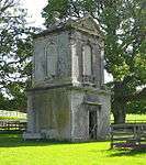 | |||
| Byres Tower | 55°59′00″N 2°48′35″W | Category B | 43534 | | |||
| Huntington House, S Gateway | 55°57′34″N 2°49′37″W | Category B | 43544 | | |||
| Monkrigg | 55°56′31″N 2°45′30″W | Category B | 43552 | | |||
| Slateford | 55°54′47″N 2°45′04″W | Category C(S) | 43557 | | |||
| St Laurence House West Road | 55°57′16″N 2°47′52″W | Category B | 34464 | | |||
| St Laurence Cottage West Road | 55°57′14″N 2°47′54″W | Category C(S) | 34465 | | |||
| 19 Church Street | 55°57′17″N 2°46′27″W | Category B | 34354 | | |||
| Church Hall Church Street | 55°57′19″N 2°46′27″W | Category C(S) | 34357 | | |||
| Trinity Episcopal Church Church Street | 55°57′20″N 2°46′24″W | Category B | 34360 | | |||
| 5 The Sands | 55°57′16″N 2°46′23″W | Category C(S) | 34365 | | |||
| Hadley Court Sidegate | 55°57′12″N 2°46′29″W | Category B | 34379 | | |||
| Maitlandfield Hotel Sidegate | 55°57′10″N 2°46′31″W | Category B | 34380 | | |||
| Tyne Park House Poldrate | 55°57′08″N 2°46′23″W | Category B | 34398 | | |||
| Waterloo Bridge | 55°57′03″N 2°46′25″W | Category B | 34399 | | |||
| Templeton's Corn Mill Poldrate | 55°57′07″N 2°46′26″W | Category B | 34401 | | |||
| Malt Buildings Poldrate | 55°57′06″N 2°46′27″W | Category B | 34403 | | |||
| Tyneside Tavern Buildings Poldrate | 55°57′07″N 2°46′28″W | Category C(S) | 34405 | | |||
| Tenterfield House Dunbar Road | 55°57′30″N 2°46′37″W | Category B | 34430 | | |||
| 25 Dunbar Road | 55°57′36″N 2°46′37″W | Category C(S) | 34433 | | |||
| 27 Dunbar Road | 55°57′36″N 2°46′37″W | Category B | 34434 | | |||
| Eastwood Off Newton Port | 55°57′24″N 2°46′36″W | Category B | 34437 | | |||
| Fairfields Newton Port | 55°57′26″N 2°46′40″W | Category C(S) | 34438 | | |||
| Florabank House Florabank Road | 55°57′32″N 2°46′47″W | Category C(S) | 34439 | | |||
| Ferguson Monument West End | 55°57′19″N 2°47′06″W | Category B | 34448 | | |||
| 3, 4 West End | 55°57′20″N 2°47′04″W | Category B | 34455 | | |||
| 54 High Street, Seed Merchants | 55°57′19″N 2°46′44″W | Category C(S) | 34243 | | |||
| The Pend House 1A Court St. Haddington | 55°57′19″N 2°46′46″W | Category C(S) | 34250 | | |||
| St Helen's Paterson Place | 55°57′16″N 2°46′46″W | Category B | 34253 | | |||
| 29 Court Street | 55°57′19″N 2°46′54″W | Category B | 34265 | | |||
| Lyndhurst 33 Court Street | 55°57′19″N 2°46′55″W | Category B | 34267 | | |||
| 2, 4, 6, Court St | 55°57′21″N 2°46′45″W | Category C(S) | 34291 | | |||
| Drinking Fountain Court Street | 55°57′20″N 2°46′49″W | Category C(S) | 34293 | | |||
| 45, 46 Market Street | 55°57′21″N 2°46′43″W | Category B | 34295 | | |||
| 34, 35, 36 Market Street | 55°57′21″N 2°46′41″W | Category B | 34299 | | |||
| 14, 15 Market St | 55°57′22″N 2°46′35″W | Category B | 34311 | | |||
| 77 Market Street | 55°57′21″N 2°46′33″W | Category B | 34320 | | |||
| 68, 69 Market Street | 55°57′20″N 2°46′36″W | Category B | 34325 | | |||
| 8, 9, 10 Hardgate | 55°57′20″N 2°46′29″W | Category C(S) | 34342 | | |||
| 14 Hardgate | 55°57′21″N 2°46′29″W | Category B | 34344 | | |||
| 15 Hardgate | 55°57′21″N 2°46′29″W | Category C(S) | 34345 | | |||
| Building At Rear Of 13, 14 High Street | 55°57′18″N 2°46′33″W | Category B | 34215 | | |||
| 23, 24 High Street | 55°57′19″N 2°46′35″W | Category B | 34223 | | |||
| Building At Rear Of 31 High Street | 55°57′18″N 2°46′36″W | Category B | 34228 | | |||
| 40, 41, 42 High Street | 55°57′19″N 2°46′39″W | Category B | 34233 | | |||
| Huntington House Stables | 55°57′52″N 2°49′33″W | Category C(S) | 13199 | | |||
| West Bearford Farmhouse | 55°56′59″N 2°43′41″W | Category C(S) | 10822 | | |||
| Aberlady Road, Herdmanflatt Hospital, Ancillary Building | 55°57′36″N 2°47′14″W | Category C(S) | 48293 | | |||
| Byres Steading, Cartshed And Granary | 55°58′57″N 2°48′43″W | Category C(S) | 43533 | | |||
| East Bearford Bridge | 55°57′47″N 2°43′07″W | Category C(S) | 43541 | | |||
| East Bearford Farmhouse | 55°57′44″N 2°42′49″W | Category C(S) | 43542 | | |||
| Lennoxlove House, West Lodge | 55°56′10″N 2°47′36″W | Category C(S) | 43551 | | |||
| Ugston Old Farm | 55°57′46″N 2°48′48″W | Category A | 43560 | | |||
| Trinity College Tyne Close At Rear Of Church Hall | 55°57′19″N 2°46′27″W | Category B | 34358 | | |||
| 2 The Sands | 55°57′17″N 2°46′24″W | Category B | 34363 | | |||
| Summerfield House Sidegate | 55°57′14″N 2°46′30″W | Category B | 34376 | | |||
| 1 St Ann's Place | 55°57′18″N 2°46′29″W | Category B | 34384 | | |||
| Haddington House Sidegate Lamp Of The Lothian, Collegiate Centre | 55°57′15″N 2°46′28″W | Category A | 34388 |  | |||
| Doocot Lady Kitty's Garden | 55°57′16″N 2°46′21″W | Category B | 34393 | | |||
| Bridge Youth Club 11 Poldrate | 55°57′07″N 2°46′29″W | Category B | 34404 | | |||
| Haddington Maltings | 55°57′03″N 2°46′45″W | Category C(S) | 34408 | | |||
| Holme Cottage Distillery Park | 55°57′02″N 2°46′54″W | Category B | 34410 | | |||
| St Martin's Chapel Bullet Loan | 55°57′22″N 2°46′07″W | Category B | 34426 | | |||
| 8 Florabank Road | 55°57′32″N 2°46′47″W | Category C(S) | 34441 | | |||
| The Hollies Station Road West End | 55°57′11″N 2°47′08″W | Category B | 34459 | | |||
| House At Rear Of 43 High Street | 55°57′18″N 2°46′39″W | Category B | 34235 | | |||
| 50, 51, High Street Carlyle House | 55°57′19″N 2°46′42″W | Category A | 34239 | | |||
| 27 Court Street | 55°57′19″N 2°46′53″W | Category B | 34261 | | |||
| West Church (C Of S) Court Street (Former Free Church) | 55°57′20″N 2°47′00″W | Category B | 34275 | | |||
| Tower Of Former Church St John's West Court Street | 55°57′20″N 2°47′00″W | Category C(S) | 34277 | | |||
| 48 Court Street | 55°57′20″N 2°46′54″W | Category B | 34280 | | |||
| Bank Of Scotland Court Street | 55°57′21″N 2°46′54″W | Category A | 34281 | .jpg) | |||
| 32 Court Street Royal Bank Of Scotland | 55°57′21″N 2°46′50″W | Category B | 34285 | | |||
| 3, 4 Mitchell's Close Off Market Street | 55°57′22″N 2°46′38″W | Category B | 34305 | | |||
| 4, 4B Market Street | 55°57′22″N 2°46′32″W | Category B | 34317 | | |||
| 63 Market Street | 55°57′20″N 2°46′37″W | Category C(S) | 34328 | | |||
| Warehouse Kilpair Street At Rear Of 85 High Street | 55°57′20″N 2°46′33″W | Category C(S) | 34331 | | |||
| 1-7 Brown Street At Rear Of 90 High Street | 55°57′20″N 2°46′32″W | Category B | 34333 | | |||
| 57, 58 High Street | 55°57′20″N 2°46′42″W | Category B | 34186 | | |||
| 72 High Street | 55°57′20″N 2°46′37″W | Category B | 34193 | | |||
| George Hotel High Street | 55°57′20″N 2°46′31″W | Category B | 34204 | | |||
| 92, 93A And 93B High Street | 55°57′19″N 2°46′31″W | Category B | 34205 | | |||
| Lennoxlove House, Sundial | 55°56′20″N 2°46′38″W | Category A | 10815 | | |||
| Abbey Bridge | 55°57′42″N 2°44′58″W | Category A | 10820 | 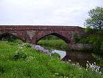 | |||
| Amisfield Gothic Lodge | 55°57′59″N 2°45′24″W | Category B | 43527 | | |||
| Amisfield Park Boundary Walls | 55°57′51″N 2°45′05″W | Category C(S) | 43529 | | |||
| Myreside | 55°55′04″N 2°44′28″W | Category C(S) | 43554 | | |||
| Seggarsdean Reservoir | 55°57′02″N 2°44′10″W | Category C(S) | 43556 | | |||
| Minto Cottage West Road | 55°57′14″N 2°47′56″W | Category C(S) | 34467 | | |||
| The Rectory Church Street | 55°57′19″N 2°46′26″W | Category B | 34359 | | |||
| 3, 4 Sidegate | 55°57′18″N 2°46′30″W | Category B | 34368 | | |||
| 8 St Ann's Place | 55°57′18″N 2°46′29″W | Category B | 34382 | | |||
| 32, 34 Sidegate | 55°57′16″N 2°46′29″W | Category B | 34386 | | |||
| 30 Sidegate | 55°57′16″N 2°46′28″W | Category C(S) | 34387 | | |||
| Adam Paterson Mill, West Mills Distillery Park | 55°57′03″N 2°46′55″W | Category B | 34412 | | |||
| St Fillans St Martin's Gate | 55°57′22″N 2°46′09″W | Category C(S) | 34425 | | |||
| 6 Florabank Road | 55°57′31″N 2°46′47″W | Category C(S) | 34440 | | |||
| Somnerfield Cottage Hospital Road | 55°57′21″N 2°47′27″W | Category C(S) | 34462 | | |||
| 48, 49 High Street Bank Of Scotland | 55°57′18″N 2°46′41″W | Category B | 34238 |  | |||
| 53 High Street | 55°57′19″N 2°46′44″W | Category C(S) | 34242 | | |||
| Cross, High Street | 55°57′19″N 2°46′35″W | Category B | 34245 | | |||
| 3, 4, 5 Lodge Street | 55°57′19″N 2°46′43″W | Category B | 34248 | | |||
| 1 Court Street | 55°57′19″N 2°46′46″W | Category B | 34254 | | |||
| Corn Exchange Court Street | 55°57′18″N 2°46′49″W | Category B | 34257 | | |||
| Hilton Lodge Court Street | 55°57′21″N 2°46′59″W | Category B | 34276 | | |||
| Post Office 52 Court Street | 55°57′20″N 2°46′54″W | Category B | 34279 | | |||
| 29(Part) And 30 Market Street | 55°57′21″N 2°46′40″W | Category B | 34301 | | |||
| 28 And 29 Market Street | 55°57′21″N 2°46′39″W | Category B | 34302 | | |||
| 7, 8 Market Street | 55°57′22″N 2°46′33″W | Category A | 34315 | | |||
| Kinloch Or Gilmerton House 1 Market Street | 55°57′23″N 2°46′32″W | Category B | 34319 | | |||
| 59, 60 High Street | 55°57′20″N 2°46′41″W | Category B | 34187 | | |||
| 64, 65 High Street | 55°57′20″N 2°46′40″W | Category B | 34189 | | |||
| 69, 70, 71 High Street | 55°57′20″N 2°46′38″W | Category B | 34192 | | |||
| House At Rear Of 78 High Street | 55°57′20″N 2°46′36″W | Category B | 34197 | | |||
| 27, 28 High Street | 55°57′19″N 2°46′36″W | Category B | 34225 | | |||
| Building At Rear Of 29, 30 High Street | 55°57′18″N 2°46′36″W | Category B | 34227 | | |||
| Alderston Coach House, With Kennels | 55°57′42″N 2°48′11″W | Category A | 10835 | | |||
| 1 And 2 Mitchell's Close (Off Market Street) | 55°57′22″N 2°46′39″W | Category B | 48152 | | |||
| Westfield House, With Gatepiers And Boundary Wall | 55°56′01″N 2°48′06″W | Category B | 43563 | | |||
| Camptoun House, Camptoun Lodge And East Gates | 55°59′21″N 2°47′49″W | Category B | 43536 | | |||
| Town Walls | 55°57′28″N 2°46′38″W | Category C(S) | 34468 | | |||
| 13, 14, 15, 16 Church Street | 55°57′17″N 2°46′26″W | Category B | 34352 | | |||
| 2 Church Street Corner Of Hardgate | 55°57′19″N 2°46′29″W | Category B | 34355 | | |||
| 38 Sidegate | 55°57′18″N 2°46′29″W | Category B | 34381 | | |||
| Appleloft Haddington House Sidegate | 55°57′15″N 2°46′25″W | Category B | 34389 | | |||
| St Mary's Catholic Church Poldrate | 55°57′09″N 2°46′25″W | Category B | 34397 | | |||
| 1 Bridge Street | 55°57′18″N 2°46′16″W | Category B | 34415 | | |||
| House And Shop Bridge Street | 55°57′17″N 2°46′12″W | Category C(S) | 34417 | | |||
| Victoria Bridge Over River Tyne, Victoria Terrace | 55°57′23″N 2°46′25″W | Category B | 34422 | | |||
| Cottages St Martins Close J Robertson Smiddy | 55°57′21″N 2°46′19″W | Category C(S) | 34423 | | |||
| Gimmers Mill | 55°57′24″N 2°46′21″W | Category B | 34428 | | |||
| 16 Florabank Road | 55°57′32″N 2°46′47″W | Category C(S) | 34442 | | |||
| Templedean Hall(Formerly Children's Home) Off Herdmanflatt | 55°57′38″N 2°46′49″W | Category B | 34443 | | |||
| Rosehall Foundry, Haddington | 55°57′14″N 2°47′18″W | Category C(S) | 34452 | | |||
| 1 West End | 55°57′20″N 2°47′03″W | Category C(S) | 34453 | | |||
| 2 West End | 55°57′20″N 2°47′03″W | Category C(S) | 34454 | | |||
| Warehouse Next To 54 High Street | 55°57′19″N 2°46′45″W | Category B | 34244 | | |||
| 1, 2 Lodge Street | 55°57′19″N 2°46′43″W | Category B | 34246 | | |||
| Plough Tavern Court Street | 55°57′19″N 2°46′48″W | Category B | 34256 | | |||
| County Buildings Court Street | 55°57′18″N 2°46′51″W | Category B | 34260 | | |||
| 57 Court Street | 55°57′19″N 2°47′01″W | Category C(S) | 34271 | | |||
| 54, 56 Court Street | 55°57′20″N 2°46′56″W | Category B | 34278 | | |||
| 40 Court Street | 55°57′20″N 2°46′51″W | Category C(S) | 34282 | | |||
| 39, 40, 41 Market Street | 55°57′21″N 2°46′42″W | Category B | 34297 | | |||
| 26, 27 Market St | 55°57′21″N 2°46′39″W | Category A | 34303 | | |||
| 5, 6 Mitchell's Close Off Market Street | 55°57′22″N 2°46′39″W | Category B | 34304 | | |||
| 16 Market Street | 55°57′22″N 2°46′36″W | Category B | 34310 | | |||
| 12 Market Street (Off Market St) | 55°57′22″N 2°46′34″W | Category B | 34313 | | |||
| Gardner's Arms Adjoining No 73 Market Street | 55°57′21″N 2°46′34″W | Category B | 34322 | | |||
| 1 Kilpair Street | 55°57′21″N 2°46′33″W | Category C(S) | 34330 | | |||
| Warehouse Kilpair Street At Rear Of 77 Market Street | 55°57′21″N 2°46′33″W | Category B | 34335 | | |||
| 1 And 2 Hardgate | 55°57′19″N 2°46′29″W | Category B | 34338 | | |||
| 3 Hardgate | 55°57′19″N 2°46′29″W | Category B | 34339 | | |||
| 6, 7 Hardgate | 55°57′20″N 2°46′29″W | Category B | 34341 | | |||
| 78 High Street | 55°57′20″N 2°46′36″W | Category B | 34196 | | |||
| 88, 89 High Street | 55°57′20″N 2°46′33″W | Category B | 34202 | | |||
| Building At Rear Of 9 High Street | 55°57′18″N 2°46′32″W | Category B | 34211 | | |||
| 10, 11 High Street | 55°57′18″N 2°46′32″W | Category B | 34212 | | |||
| Building At Rear Of 10, 11 High Street | 55°57′18″N 2°46′32″W | Category B | 34213 | | |||
| Building At Rear Of 15 High Street | 55°57′18″N 2°46′33″W | Category B | 34217 | | |||
| 19, 20 High Street | 55°57′19″N 2°46′34″W | Category B | 34219 | | |||
| 25, 26 High Street | 55°57′19″N 2°46′35″W | Category B | 34224 | | |||
| 32 High Street | 55°57′19″N 2°46′37″W | Category B | 34229 | | |||
| 35, 36 High Street | 55°57′19″N 2°46′37″W | Category B | 34231 | | |||
| Aberlady Road, Herdmanflatt Hospital | 55°57′36″N 2°47′12″W | Category C(S) | 48292 | |
Key
The scheme for classifying buildings in Scotland is:
- Category A: "buildings of national or international importance, either architectural or historic; or fine, little-altered examples of some particular period, style or building type."[1]
- Category B: "buildings of regional or more than local importance; or major examples of some particular period, style or building type, which may have been altered."[1]
- Category C: "buildings of local importance; lesser examples of any period, style, or building type, as originally constructed or moderately altered; and simple traditional buildings which group well with other listed buildings."[1]
In March 2016 there were 47,288 listed buildings in Scotland. Of these, 8% were Category A, and 50% were Category B, with the remaining 42% being Category C.[2]
gollark: You know, sometimes I'd actually want viewbombing. Zyus are evil.
gollark: Are you suggesting that viewbombers also AR or something?
gollark: I generally miss eggs by just clicking past to the next biome then suddenly noticing then going back.
gollark: I generally try to fully read descriptions before clicking them, which may be why I usually can't get anything.
gollark: They see "gold" and forget "wait, golds aren't actually described as gold".
Notes
- Sometimes known as OSGB36, the grid reference (where provided) is based on the British national grid reference system used by the Ordnance Survey.
• "Guide to National Grid". Ordnance Survey. Retrieved 12 December 2007.
• "Get-a-map". Ordnance Survey. Retrieved 17 December 2007. - Historic Environment Scotland assign a unique alphanumeric identifier to each designated site in Scotland, for listed buildings this always begins with "LB", for example "LB12345".
References
- All entries, addresses and coordinates are based on data from Historic Scotland. This data falls under the Open Government Licence
- "What is Listing?". Historic Environment Scotland. Retrieved 29 May 2018.
- Scotland's Historic Environment Audit 2016 (PDF). Historic Environment Scotland and the Built Environment Forum Scotland. pp. 15–16. Retrieved 29 May 2018.
This article is issued from Wikipedia. The text is licensed under Creative Commons - Attribution - Sharealike. Additional terms may apply for the media files.