List of listed buildings in Greenock
List
| Name | Location | Date Listed | Grid Ref. [note 1] | Geo-coordinates | Notes | LB Number [note 2] | Image |
|---|---|---|---|---|---|---|---|
| Former Church Of Scotland, 25, 27 Madeira Street | 55°57′24″N 4°46′44″W | Category B | 34129 | 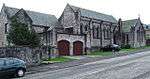 | |||
| 24 And 26 Margaret Street | 55°57′22″N 4°46′20″W | Category B | 34132 |  | |||
| County Court Buildings, Nelson Street | 55°56′58″N 4°45′55″W | Category B | 34133 | | |||
| Lindores, 61 Newark Street | 55°57′30″N 4°47′07″W | Category B | 34135 | | |||
| Sir Gabriel Wood's Mariners' Home, Newark Street (Including Front Wall Gate Etc) | 55°57′33″N 4°47′14″W | Category A | 34136 | 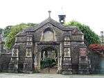 | |||
| Birnam, 88, 90 Newark Street | 55°57′35″N 4°47′06″W | Category B | 34140 | | |||
| Steamboat Quay, Former Harbour Trust Offices | 55°56′53″N 4°44′58″W | Category C(S) | 34176 | | |||
| Clarence Street, Tobacco Warehouse | 55°57′09″N 4°45′39″W | Category B | 34180 | | |||
| 2 Ardgowan Square | 55°57′08″N 4°46′03″W | Category C(S) | 34076 | | |||
| 9 Ardgowan Square | 55°57′09″N 4°46′09″W | Category C(S) | 34079 | | |||
| 23 And 24 Ardgowan Square | 55°57′05″N 4°46′09″W | Category B | 34082 | | |||
| Keir Hardie House, 4 Brougham Street | 55°57′13″N 4°45′54″W | Category B | 34092 | | |||
| Former Clydesdale Bank, Cathcart Square And 130, 132 And 134 Cathcart Street | 55°56′50″N 4°45′20″W | Category B | 34098 | 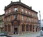 | |||
| Custom House, Custom House Place | 55°56′53″N 4°45′04″W | Category A | 34100 | | |||
| Watt Memorial School, Dalrymple Street | 55°56′52″N 4°45′19″W | Category B | 34101 | | |||
| 15 Esplanade And 64 Eldon Street | 55°57′34″N 4°46′29″W | Category B | 34108 | | |||
| 153, 153A And 155 Finnart Street | 55°57′18″N 4°46′46″W | Category B | 34111 | | |||
| Westburn Church, Nelson Street (Formerly The Old Kirk And St Lukes Church Of Scotland) | 55°56′56″N 4°46′00″W | Category A | 34134 | 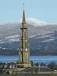 | |||
| 1 Shaw Place | 55°56′47″N 4°45′26″W | Category B | 34143 | | |||
| 2 Shaw Place | 55°56′47″N 4°45′27″W | Category B | 34144 | | |||
| 5 Shaw Place | 55°56′47″N 4°45′30″W | Category B | 34147 | | |||
| 72 Union Street/27 Fox Street | 55°57′22″N 4°46′27″W | Category B | 34164 | | |||
| 14 William Street | 55°56′51″N 4°45′21″W | Category B | 34171 | | |||
| Harbour Light And Clock, Custom House | 55°56′54″N 4°45′03″W | Category B | 34182 | | |||
| Cedars School Of Excellence, 31 Ardgowan Square (Formerly The Greenock Club) | 55°57′05″N 4°46′03″W | Category B | 34086 | | |||
| 44 Ardgowan Street | 55°57′13″N 4°46′21″W | Category B | 34089 | | |||
| 189 Eldon Street | 55°57′42″N 4°47′25″W | Category C(S) | 34104 | | |||
| 13, 14, 15 And 16 Seafield Cottage Lane, Seafield Cottage | 55°57′33″N 4°46′26″W | Category B | 34106 | | |||
| Lindon Mansions, 48 Forsyth Street, (Former Glenpark Teachers Centre And Former Glenburn Special School) | 55°57′14″N 4°46′26″W | Category B | 34112 | | |||
| Baptist Church, George Square | 55°57′02″N 4°45′49″W | Category C(S) | 34113 | | |||
| Greenock Cemetery, Including Highland Mary (Mary Campbell Monument), James Watt Cairn, Cemetery Gates And Boundary Walls | 55°56′50″N 4°46′17″W | Category B | 34118 | | |||
| 1 South Street, Greenock Crematorium | 55°56′54″N 4°46′51″W | Category C(S) | 34119 | | |||
| Municipal Buildings, Clyde Square ( Wallace Place/Dalrymple Street) | 55°56′53″N 4°45′22″W | Category A | 34122 | | |||
| 20, 22 Margaret Street | 55°57′23″N 4°46′20″W | Category B | 34131 | | |||
| Madeira Lodge 16 Newark Street | 55°57′28″N 4°46′38″W | Category C(S) | 34138 | | |||
| Ardgowan Parish Church, Union Street. (Former Trinity Church Of Scotland) | 55°57′12″N 4°46′13″W | Category B | 34152 | 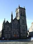 | |||
| 20 Union Street | 55°57′06″N 4°46′00″W | Category C(S) | 34157 | | |||
| 34, 36 Union Street | 55°57′13″N 4°46′11″W | Category C(S) | 34159 | | |||
| 64, 66 And 66A Union Street | 55°57′21″N 4°46′25″W | Category B | 34163 | | |||
| Well Park: Walls And Gates | 55°56′44″N 4°45′21″W | Category C(S) | 34165 | 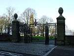 | |||
| 49-55 West Blackhall Street And 1, 3, 5 Argyle Street | 55°57′02″N 4°45′43″W | Category B | 34167 | | |||
| 9 William Street | 55°56′51″N 4°45′19″W | Category B | 34169 | | |||
| Former Greenock Provident Bank, 11 William Street | 55°56′51″N 4°45′19″W | Category B | 34170 | | |||
| Esplanade, Cast-Iron Navigation Light | 55°57′37″N 4°46′34″W | Category B | 34179 | | |||
| Ker Street, Glebe Sugar Refinery | 55°57′11″N 4°45′46″W | Category B | 34181 | | |||
| 3, & 4 Ardgowan Square | 55°57′09″N 4°46′04″W | Category C(S) | 34077 | | |||
| 37 Ardgowan Street | 55°57′11″N 4°46′20″W | Category B | 34088 | | |||
| 2 Brougham Street And 12 Patrick Street | 55°57′12″N 4°45′53″W | Category B | 34091 | | |||
| 8 Brougham Street | 55°57′13″N 4°45′55″W | Category B | 34094 | | |||
| Old West Kirk, Campbell Street, Including Church Hall, Boundary Walls And Railings | 55°57′22″N 4°46′03″W | Category B | 34095 |  | |||
| Wellpark Mid Kirk, Cathcart Square | 55°56′50″N 4°45′23″W | Category A | 34096 | 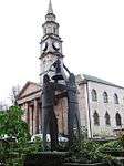 | |||
| Former Royal Bank, 96 Cathcart Street And Cross Shore Street | 55°56′49″N 4°45′15″W | Category B | 34097 | | |||
| Old Toll House, 293 Eldon Street | 55°57′31″N 4°47′54″W | Category B | 34105 | 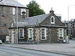 | |||
| Greenock West United Reformed Church, George Square (Formerly George Square Congregational Church) | 55°57′02″N 4°45′52″W | Category B | 34116 | | |||
| 22B, 22C And 22D Esplanade And 90 Eldon Street, Firth House, With Boundary Walls And Gatepiers | 55°57′36″N 4°46′39″W | Category C(S) | 50050 | | |||
| Greenbank Institute Former Greenbank Church, Kelly Street | 55°56′56″N 4°46′17″W | Category B | 34126 | | |||
| St. Mary's R.C. Church And Presbytery House, 14 Patrick Street | 55°57′11″N 4°45′56″W | Category B | 34142 | | |||
| 30 West Stewart Street | 55°57′05″N 4°45′48″W | Category B | 34168 | | |||
| Greenock, James Watt Dock, Titan Cantilever Crane | 55°56′38″N 4°43′50″W | Category A | 34175 | 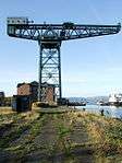 | |||
| 80-92 Cathcart Street, Former Post Office Building | 55°56′49″N 4°45′13″W | Category B | 34183 | 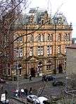 | |||
| Tontine Hotel, 5 Ardgowan Square | 55°57′10″N 4°46′05″W | Category A | 34078 | 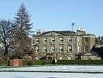 | |||
| 19, 20 & 21 Ardgowan Square | 55°57′05″N 4°46′10″W | Category C(S) | 34081 | | |||
| 30 Ardgowan Square | 55°57′05″N 4°46′04″W | Category C(S) | 34085 | | |||
| 6 Brougham Street | 55°57′13″N 4°45′54″W | Category B | 34093 | | |||
| 'Bagatelle' 47 Eldon Street | 55°57′31″N 4°46′31″W | Category B | 34103 | | |||
| 16 Esplanade And 68 Eldon Street | 55°57′34″N 4°46′30″W | Category B | 34109 | | |||
| Scott's Dry Dock With Outer Basin | 55°56′40″N 4°44′40″W | Category A | 50131 | 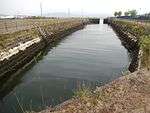 | |||
| Eldon Street, Former Torpedo Works At Fort Matilda Industrial Estate | 55°57′41″N 4°47′45″W | Category B | 50579 | | |||
| Former St. Columba's Gaelic Church, Grey Place And Patrick Street | 55°57′12″N 4°45′51″W | Category B | 34121 | | |||
| 29 Union Street | 55°57′12″N 4°46′12″W | Category C(S) | 34151 | | |||
| 38, 40 Union Street | 55°57′14″N 4°46′12″W | Category C(S) | 34160 | | |||
| Fort Matilda Railway Station | 55°57′33″N 4°47′43″W | Category B | 34174 | 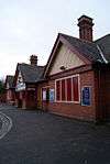 | |||
| 16 Ardgowan Square And 11 Robertson Street | 55°57′06″N 4°46′12″W | Category B | 34080 | | |||
| 5, 7 Bank Street, Former Premises Of Renfrewshire Bank | 55°56′46″N 4°45′25″W | Category B | 34090 | | |||
| Greenock Crematorium, 1 South Street, Summerhouse Tempietto (Formerly Of Caddle Hill House Now To North Of Greenock Crematorium) | 55°56′55″N 4°46′37″W | Category B | 34120 | | |||
| Bellevue, 8 Johnston Street | 55°57′29″N 4°46′27″W | Category B | 34125 | | |||
| 21 Madeira Street | 55°57′28″N 4°46′41″W | Category B | 34128 | | |||
| 31 Margaret Street | 55°57′20″N 4°46′19″W | Category B | 34130 | | |||
| 14 Union Street | 55°57′05″N 4°45′57″W | Category C(S) | 34155 | | |||
| 16 Union Street | 55°57′06″N 4°45′59″W | Category C(S) | 34156 | | |||
| St Patrick's Rc Church And Presbytery, Orangefield And Holmscroft Street | 55°56′48″N 4°46′12″W | Category A | 34173 | | |||
| Ardgowan Estate Office, Mansion House, Ardgowan Square | 55°57′08″N 4°46′02″W | Category B | 34075 | | |||
| 32 Ardgowan Square | 55°57′06″N 4°46′02″W | Category C(S) | 34087 | | |||
| 84 Eldon Street And Madeira Lodge, 4 Madeira Street | 55°57′35″N 4°46′37″W | Category C(S) | 34107 | | |||
| Inverkip Street Burial Ground | 55°56′50″N 4°45′56″W | Category C(S) | 34123 | 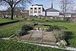 | |||
| 98,100 Newark Street | 55°57′36″N 4°47′10″W | Category B | 34141 | | |||
| 3 Shaw Place | 55°56′47″N 4°45′28″W | Category B | 34145 | | |||
| 4 Shaw Place | 55°56′47″N 4°45′29″W | Category B | 34146 | | |||
| Watt Library And Mclean Museum Union Street, Kelly Street And Watt Street | 55°57′03″N 4°45′58″W | Category A | 34148 | 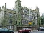 | |||
| 12 Union Street | 55°57′05″N 4°45′57″W | Category C(S) | 34154 | | |||
| Kilmalcolm Road, St Laurence's Rc Church And Presbytery | 55°56′23″N 4°44′48″W | Category A | 34184 | | |||
| 26, 27 And 28 Ardgowan Square | 55°57′04″N 4°46′05″W | Category B | 34083 | | |||
| 34 Esplanade And 134 Eldon Street | 55°57′40″N 4°46′50″W | Category B | 34110 | | |||
| 5 George Square | 55°57′03″N 4°45′50″W | Category C(S) | 34114 | | |||
| St. George's North Church Of Scotland, George Square | 55°57′00″N 4°45′50″W | Category B | 34117 | | |||
| 12 Newark Street | 55°57′27″N 4°46′37″W | Category B | 34137 | | |||
| Finnart - St Paul's Church Newark Street | 55°57′31″N 4°46′53″W | Category A | 34139 | | |||
| 21 Union Street | 55°57′10″N 4°46′09″W | Category C(S) | 34149 | | |||
| 27 Union Street | 55°57′11″N 4°46′11″W | Category C(S) | 34150 | | |||
| St. John The Evangelist's Episcopal Church, Union Street | 55°57′04″N 4°45′55″W | Category B | 34153 | | |||
| 22 Union Street/23 Patrick Street | 55°57′07″N 4°46′00″W | Category C(S) | 34158 | | |||
| Convent, Little Sisters Of The Poor, Union Street (Western Block Only) | 55°57′17″N 4°46′13″W | Category B | 34161 | | |||
| 62 Union Street/32 Margaret Street | 55°57′20″N 4°46′24″W | Category B | 34162 | | |||
| Well Park: Well | 55°56′46″N 4°45′16″W | Category A | 34166 | 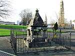 | |||
| Warehouse (Clyde Port Authority) East Hamilton Street, Cartsdyke | 55°56′33″N 4°43′35″W | Category A | 34172 | 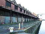 | |||
| Bearhope/Roxburgh Street, Mcewing Building Contractors | 55°56′46″N 4°45′50″W | Category B | 34177 | | |||
| 29 Ardgowan Square | 55°57′05″N 4°46′05″W | Category C(S) | 34084 | | |||
| 6 Cathcart Square, Cathcart House (Formerly The Carrick Building) | 55°56′51″N 4°45′21″W | Category B | 34099 | | |||
| 6 George Square | 55°57′02″N 4°45′51″W | Category C(S) | 34115 | |
Key
The scheme for classifying buildings in Scotland is:
- Category A: "buildings of national or international importance, either architectural or historic; or fine, little-altered examples of some particular period, style or building type."[1]
- Category B: "buildings of regional or more than local importance; or major examples of some particular period, style or building type, which may have been altered."[1]
- Category C: "buildings of local importance; lesser examples of any period, style, or building type, as originally constructed or moderately altered; and simple traditional buildings which group well with other listed buildings."[1]
In March 2016 there were 47,288 listed buildings in Scotland. Of these, 8% were Category A, and 50% were Category B, with the remaining 42% being Category C.[2]
gollark: IIRC the Old Testament actually contains recordings of commands by god to kill specific groups.
gollark: Not all religions say "be peaceful and not mean to each other", though?
gollark: I mean, if you believe Religion 1 and believe that everyone who believes Religion 2 will go to hell and suffer forever, then you obviously don't want Religion 2 to spread.
gollark: They're pretty rational if you actually believe your religion is true, though.
gollark: Looking at religious conflicts probably doesn't require knowing about all the deep details of the religions involved, because people do tribalism and probably do not meaningfully care about the actual underlying point.
Notes
- Sometimes known as OSGB36, the grid reference (where provided) is based on the British national grid reference system used by the Ordnance Survey.
• "Guide to National Grid". Ordnance Survey. Retrieved 2007-12-12.
• "Get-a-map". Ordnance Survey. Retrieved 2007-12-17. - Historic Environment Scotland assign a unique alphanumeric identifier to each designated site in Scotland, for listed buildings this always begins with "LB", for example "LB12345".
References
- All entries, addresses and coordinates are based on data from Historic Scotland. This data falls under the Open Government Licence
- "What is Listing?". Historic Environment Scotland. Retrieved 29 May 2018.
- Scotland's Historic Environment Audit 2016 (PDF). Historic Environment Scotland and the Built Environment Forum Scotland. pp. 15–16. Retrieved 29 May 2018.
This article is issued from Wikipedia. The text is licensed under Creative Commons - Attribution - Sharealike. Additional terms may apply for the media files.