List of listed buildings in Gourock, Inverclyde
List
| Name | Location | Date Listed | Grid Ref. [note 1] | Geo-coordinates | Notes | LB Number [note 2] | Image |
|---|---|---|---|---|---|---|---|
| 10-16 (Even Nos) Steel Street | 55°57′24″N 4°48′20″W | Category C(S) | 34027 |  | |||
| 45 Victoria Road With Terracing Walls And Railings | 55°57′15″N 4°49′59″W | Category C(S) | 34032 | | |||
| 46-52 (Even Nos) Albert Road With Boundary Wall And Gatepiers | 55°57′33″N 4°49′24″W | Category B | 33981 | | |||
| 80,82 And 84 Albert Road | 55°57′30″N 4°49′30″W | Category B | 33983 | | |||
| 2-12 (Even Nos) Ashgrove Avenue, Viewfield | 55°57′14″N 4°50′02″W | Category C(S) | 33989 | | |||
| 21 And 22 Ashton Road | 55°57′17″N 4°50′01″W | Category C(S) | 33993 | | |||
| 50 Ashton Road With Boundary Wall And Gatepiers | 55°57′14″N 4°50′14″W | Category B | 33997 | | |||
| 25 And 27 Kempock Place | 55°57′42″N 4°49′06″W | Category C(S) | 34016 | | |||
| Royal Street, Old Gourock And Ashton Parish Church With Boundary Walls, Gatepiers And Railings | 55°57′31″N 4°48′59″W | Category B | 34021 | | |||
| Shore Street, Gamble Institute | 55°57′27″N 4°48′51″W | Category B | 34023 | | |||
| 88, 89 And 90 Shore Street And 2 And 4 John Street | 55°57′34″N 4°49′00″W | Category C(S) | 34025 | | |||
| 8 And 10 Victoria Road With Boundary Walls And Gatepiers | 55°57′17″N 4°49′40″W | Category C(S) | 34033 | | |||
| 38-44 (Even Nos) Albert Road | 55°57′33″N 4°49′24″W | Category C(S) | 33980 | | |||
| Ashton Road, Royal Gourock Yacht Club With Boundary Walls And Gatepiers | 55°57′16″N 4°50′10″W | Category C(S) | 33990 | 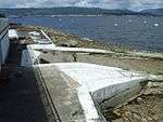 | |||
| 11 Ashton Road | 55°57′17″N 4°49′55″W | Category C(S) | 33991 | | |||
| 52 And 53 Ashton Road | 55°57′14″N 4°50′16″W | Category C(S) | 33998 | | |||
| Bath Street, St John's Church (Church Of Scotland) With Hall, Walls, Gatepiers And Lamp Standards | 55°57′39″N 4°49′12″W | Category B | 34000 | | |||
| 5 Barrhill Road With Boundary Walls, Gatepiers And Railings | 55°57′36″N 4°49′15″W | Category C(S) | 34002 | | |||
| 6 And 7 Barrhill Road | 55°57′35″N 4°49′16″W | Category C(S) | 34003 | | |||
| 1 Cloch Road | 55°57′23″N 4°48′11″W | Category C(S) | 34011 | | |||
| Cove Road And Cardwell Road, Fountain | 55°57′24″N 4°48′10″W | Category C(S) | 34012 | 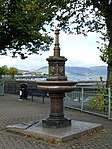 | |||
| 31-42 (Inclusive Nos) Cove Road With Boundary Walls | 55°57′25″N 4°48′26″W | Category C(S) | 34013 | | |||
| 1 Davidson Drive, West Lodge | 55°57′27″N 4°48′54″W | Category C(S) | 34014 | 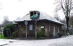 | |||
| 23 Kempock Place And 2-8 (Even Nos) Bath Street | 55°57′41″N 4°49′06″W | Category B | 34015 | | |||
| Shore Street, Municipal Buildings, Police Station And Nos 116, 117 And 118 Shore Street | 55°57′40″N 4°49′02″W | Category C(S) | 34024 | 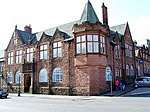 | |||
| 20 And 20A Victoria Road | 55°57′15″N 4°49′45″W | Category C(S) | 34036 | | |||
| Ashburn Gate, Queen's Residential Home For The Elderly | 55°57′20″N 4°49′43″W | Category C(S) | 33988 | | |||
| Barrhill Road, St Bartholomew's (Episcopal) Church And Boundary Wall | 55°57′35″N 4°49′20″W | Category B | 34001 | | |||
| Binnie Street, Former Gourock Primary School | 55°57′35″N 4°48′36″W | Category B | 34006 | | |||
| 51 And 53 Broomberry Drive And 38 And 40 John Street | 55°57′29″N 4°49′08″W | Category C(S) | 34007 | | |||
| 2 And 4 Broomberry Drive With Boundary Wall And Gatepiers | 55°57′31″N 4°49′19″W | Category C(S) | 34008 | | |||
| 38-44 (Even Nos) Broomberry Drive | 55°57′27″N 4°49′07″W | Category C(S) | 34009 | | |||
| Moorfield Road, Moorlea | 55°57′12″N 4°49′56″W | Category C(S) | 34019 | | |||
| 12 And 13 Albert Road | 55°57′38″N 4°49′18″W | Category C(S) | 33977 | | |||
| 16 And 17 Albert Road | 55°57′38″N 4°49′19″W | Category B | 33979 | | |||
| 86 And 88 Albert Road | 55°57′29″N 4°49′30″W | Category C(S) | 33984 | | |||
| 114 And 115 Albert Road With Boundary Wall And Gatepiers | 55°57′24″N 4°49′40″W | Category B | 33986 | | |||
| 121 Albert Road, Spinnaker Hotel | 55°57′19″N 4°49′48″W | Category C(S) | 33987 | | |||
| 41, 42 And 43 Ashton Road Whitebank | 55°57′15″N 4°50′11″W | Category B | 33995 | | |||
| 44, 44A And 45 Ashton Road | 55°57′15″N 4°50′12″W | Category C(S) | 33996 | | |||
| 54, 54A And 55 Ashton Road With Coach House | 55°57′14″N 4°50′17″W | Category B | 33999 | | |||
| 19 And 20 Moorfield Road With Boundary Wall, Gatepiers And Railings | 55°57′11″N 4°49′58″W | Category C(S) | 34020 | | |||
| 105 Shore Street And 1 And 2 Hopeton Street, Victoria Bar With Courtyard Buildings | 55°57′38″N 4°49′01″W | Category C(S) | 34026 | | |||
| 39 Tower Drive With Boundary Walls | 55°57′13″N 4°49′35″W | Category C(S) | 34028 | | |||
| 27 Victoria Road | 55°57′14″N 4°49′47″W | Category C(S) | 34031 | | |||
| 14, 16 And 18 Victoria Road, Glenacre, With Boundary Walls And Gatepiers | 55°57′16″N 4°49′42″W | Category B | 34035 | | |||
| Albert Road, Jubilee Drinking Fountain | 55°57′22″N 4°49′46″W | Category C(S) | 33975 | | |||
| 96 And 97 Albert Road With Gatepiers | 55°57′27″N 4°49′33″W | Category C(S) | 33985 | | |||
| 30, 31 And 32 Ashton Road | 55°57′16″N 4°50′04″W | Category C(S) | 33994 | | |||
| 68, 70 And 72 Cardwell Road And 41 Manor Crescent | 55°57′23″N 4°48′11″W | Category C(S) | 34010 | | |||
| 19 Victoria Road, The Croft | 55°57′14″N 4°49′41″W | Category C(S) | 34030 | | |||
| 12 Victoria Road | 55°57′17″N 4°49′41″W | Category C(S) | 34034 | | |||
| 44-50 (Even Nos) Kempock Street | 55°57′43″N 4°49′13″W | Category B | 34017 | | |||
| 7 Moorfield Road And 12 Golf Road, Royston | 55°57′12″N 4°50′01″W | Category B | 34018 | | |||
| Tower Hill, Tower | 55°57′24″N 4°49′20″W | Category B | 34029 | 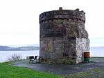 | |||
| Albert Road, War Memorial | 55°57′38″N 4°49′21″W | Category C(S) | 33976 | 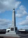 | |||
| 26 Royal Street | 55°57′33″N 4°48′59″W | Category C(S) | 34022 | | |||
| 14 Albert Road | 55°57′38″N 4°49′18″W | Category C(S) | 33978 | | |||
| 76 And 78 Albert Road With Boundary Wall And Gatepiers | 55°57′30″N 4°49′29″W | Category B | 33982 | | |||
| 17 And 18 Ashton Road | 55°57′17″N 4°49′58″W | Category B | 33992 | | |||
| 29 Barrhill Road, Craigard, With Boundary Walls And Gatepiers | 55°57′25″N 4°49′29″W | Category C(S) | 34004 | | |||
| Binnie Street, Gourock Community Education Centre, Former Gourock Central School With Boundary Walls And Railings | 55°57′31″N 4°49′02″W | Category C(S) | 34005 | 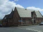 |
Key
The scheme for classifying buildings in Scotland is:
- Category A: "buildings of national or international importance, either architectural or historic; or fine, little-altered examples of some particular period, style or building type."[1]
- Category B: "buildings of regional or more than local importance; or major examples of some particular period, style or building type, which may have been altered."[1]
- Category C: "buildings of local importance; lesser examples of any period, style, or building type, as originally constructed or moderately altered; and simple traditional buildings which group well with other listed buildings."[1]
In March 2016 there were 47,288 listed buildings in Scotland. Of these, 8% were Category A, and 50% were Category B, with the remaining 42% being Category C.[2]
gollark: You input things, and it does stuff to them.
gollark: Documentation?
gollark: Manually do `ffmpeg` with `-c copy`.
gollark: They could use MySpace, but are too cool to.
gollark: Bees do not routinely have political prisoners.
Notes
- Sometimes known as OSGB36, the grid reference (where provided) is based on the British national grid reference system used by the Ordnance Survey.
• "Guide to National Grid". Ordnance Survey. Retrieved 2007-12-12.
• "Get-a-map". Ordnance Survey. Retrieved 2007-12-17. - Historic Environment Scotland assign a unique alphanumeric identifier to each designated site in Scotland, for listed buildings this always begins with "LB", for example "LB12345".
References
- All entries, addresses and coordinates are based on data from Historic Scotland. This data falls under the Open Government Licence
- "What is Listing?". Historic Environment Scotland. Retrieved 29 May 2018.
- Scotland's Historic Environment Audit 2016 (PDF). Historic Environment Scotland and the Built Environment Forum Scotland. pp. 15–16. Retrieved 29 May 2018.
This article is issued from Wikipedia. The text is licensed under Creative Commons - Attribution - Sharealike. Additional terms may apply for the media files.