List of listed buildings in Glenorchy And Inishail, Argyll and Bute
This is a list of listed buildings in the parish of Glenorchy And Inishail in Argyll and Bute, Scotland.
List
| Name | Location | Date Listed | Grid Ref. [note 1] | Geo-coordinates | Notes | LB Number [note 2] | Image |
|---|---|---|---|---|---|---|---|
| Bridge Of Orchy Station | 56°30′58″N 4°45′51″W | Category B | 13072 |  | |||
| Innishail Kirk, Near Innistrynish | 56°21′52″N 5°03′43″W | Category B | 12175 | | |||
| Fraoch Eilean Castle Fraoch Eilean, Loch Awe | 56°22′52″N 5°03′53″W | Category C(S) | 12177 | | |||
| Old Bridge Of Awe River Awe | 56°25′09″N 5°11′40″W | Category B | 12178 | | |||
| Lorne Furnace And Ancillary Buildings, Bonawe | 56°26′11″N 5°13′46″W | Category A | 12180 | 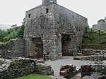 | |||
| Glenorchy Manse Clachan An Diseart | 56°24′15″N 4°58′20″W | Category B | 13808 | | |||
| Drochaid Tolaghan, Inveroran | 56°31′56″N 4°48′48″W | Category C(S) | 12169 | | |||
| St Findoca's Chapel, Innishail, Loch Awe | 56°22′27″N 5°04′54″W | Category B | 12176 | | |||
| Ardanaseig House (New Inverawe) Tirvane | 56°22′39″N 5°05′50″W | Category B | 12182 | | |||
| Dalmally Railway Station | 56°24′04″N 4°59′00″W | Category C(S) | 13352 | 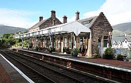 | |||
| Glenorchy Kirk Clachan An Diseart | 56°24′15″N 4°58′16″W | Category A | 12192 | 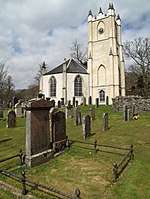 | |||
| Forest Lodge, Black Mount | 56°32′27″N 4°48′51″W | Category B | 12171 | | |||
| Lorne Furnace Jetty (Kelly's Quay) | 56°26′23″N 5°14′04″W | Category B | 12181 | | |||
| Bonawe House | 56°26′11″N 5°13′31″W | Category B | 12183 | | |||
| Ardbrecknish House | 56°20′38″N 5°07′33″W | Category B | 13071 | | |||
| Kilchurn Castle On Island In Loch Awe | 56°24′14″N 5°01′39″W | Category A | 12194 | | |||
| Duncan Ban Mcintyre Monument Beacon Hill | 56°23′18″N 5°00′28″W | Category B | 12167 | | |||
| Bridge Of Orchy River Orchy | 56°31′05″N 4°46′14″W | Category B | 12168 | | |||
| Victoria Bridge Linne Nam Beatnach | 56°32′23″N 4°48′50″W | Category B | 12170 | | |||
| Achallader Castle Near Loch Tulla | 56°33′37″N 4°43′54″W | Category B | 12173 | | |||
| New Bridge Of Awe River Awe | 56°25′12″N 5°11′39″W | Category B | 12179 | | |||
| Dalmally Bridge River Orchy | 56°24′19″N 4°58′25″W | Category B | 12193 | | |||
| Auch Bridge, Allt Chonoghlais | 56°29′02″N 4°43′06″W | Category B | 12174 | | |||
| 'The Kennels' Near Forest Lodge, Black Mount | 56°32′28″N 4°48′52″W | Category B | 12172 | | |||
| Sloy Awe Hydro Electric Scheme, Sron Mor Power Station | 56°20′13″N 4°58′33″W | Category C(S) | 51690 | |
Key
The scheme for classifying buildings in Scotland is:
- Category A: "buildings of national or international importance, either architectural or historic; or fine, little-altered examples of some particular period, style or building type."[1]
- Category B: "buildings of regional or more than local importance; or major examples of some particular period, style or building type, which may have been altered."[1]
- Category C: "buildings of local importance; lesser examples of any period, style, or building type, as originally constructed or moderately altered; and simple traditional buildings which group well with other listed buildings."[1]
In March 2016 there were 47,288 listed buildings in Scotland. Of these, 8% were Category A, and 50% were Category B, with the remaining 42% being Category C.[2]
gollark: There should be an "install potatOS" syscall.
gollark: Is it installing potatOS in the background?
gollark: By the way, I may need to borrow your soul and/or 27% of your organs.
gollark: > EvidencePotatOS privacy policy.
gollark: > DieI am in fact immortal so no.
Notes
- Sometimes known as OSGB36, the grid reference (where provided) is based on the British national grid reference system used by the Ordnance Survey.
• "Guide to National Grid". Ordnance Survey. Retrieved 2007-12-12.
• "Get-a-map". Ordnance Survey. Retrieved 2007-12-17. - Historic Environment Scotland assign a unique alphanumeric identifier to each designated site in Scotland, for listed buildings this always begins with "LB", for example "LB12345".
References
- All entries, addresses and coordinates are based on data from Historic Scotland. This data falls under the Open Government Licence
- "What is Listing?". Historic Environment Scotland. Retrieved 29 May 2018.
- Scotland's Historic Environment Audit 2016 (PDF). Historic Environment Scotland and the Built Environment Forum Scotland. pp. 15–16. Retrieved 29 May 2018.
This article is issued from Wikipedia. The text is licensed under Creative Commons - Attribution - Sharealike. Additional terms may apply for the media files.