List of listed buildings in Glenisla, Angus
List
| Name | Location | Date Listed | Grid Ref. [note 1] | Geo-coordinates | Notes | LB Number [note 2] | Image |
|---|---|---|---|---|---|---|---|
| Forter Bridge Over Balloch Burn | 56°46′07″N 3°19′54″W | Category C(S) | 11338 | 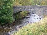 | |||
| Balloch Bridge Over Ballochburn | 56°45′58″N 3°21′42″W | Category C(S) | 11339 |  | |||
| Kilry Church | 56°40′10″N 3°13′58″W | Category C(S) | 11344 | 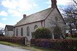 | |||
| Kirkyard Walls | 56°43′44″N 3°17′05″W | Category B | 11365 | | |||
| Kirkside (Formerly Glenisla Manse) | 56°43′46″N 3°17′01″W | Category C(S) | 11366 | | |||
| Knockshannoch - Coach House And Stables With Adjacent Pig Sty | 56°43′27″N 3°15′19″W | Category B | 11370 | | |||
| Whitchills - Limekiln | 56°43′18″N 3°15′44″W | Category B | 11331 | | |||
| Forter Castle | 56°45′58″N 3°20′21″W | Category B | 11337 |  | |||
| Old Farmhouse, Little Kilry | 56°40′58″N 3°15′48″W | Category B | 11343 | | |||
| Knock Shannoch Youth Hostel | 56°43′22″N 3°15′16″W | Category B | 11368 | | |||
| Craig - Old Burial Enclosure | 56°39′32″N 3°13′27″W | Category B | 11345 | | |||
| Knockshannoch - Old Generator House | 56°43′24″N 3°15′15″W | Category B | 11369 | | |||
| Old Bridge Of Brenlands Over River Isla. (By-Passed - Restored By Eric Feany) | 56°44′15″N 3°18′59″W | Category B | 11333 |  | |||
| West Mill - Old Farmhouse | 56°43′43″N 3°16′23″W | Category C(S) | 11334 | | |||
| Folda School Now Guards House | 56°45′54″N 3°19′49″W | Category C(S) | 11335 | | |||
| Knockshannoch Lodge | 56°43′18″N 3°15′15″W | Category B | 12384 | | |||
| Birkhill Farmhouse | 56°43′23″N 3°18′00″W | Category C(S) | 11332 | | |||
| Presnerb Farmhouse | 56°47′08″N 3°19′56″W | Category C(S) | 11340 | | |||
| Crandart Farmhouse | 56°47′33″N 3°19′47″W | Category C(S) | 11341 | | |||
| Glenisla School Bridge Over River Isla | 56°43′40″N 3°17′17″W | Category B | 11367 | | |||
| Knockshannoch - Kennels | 56°43′26″N 3°15′19″W | Category B | 11330 | | |||
| Bridge Of Forter Over River Isla | 56°46′07″N 3°19′54″W | Category B | 11336 | | |||
| Bridge Of Craigisla Over River Isla | 56°40′12″N 3°13′21″W | Category C(S) | 13747 | 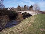 | |||
| Old School-House, Kilry | 56°40′52″N 3°15′19″W | Category B | 11342 | | |||
| Glenisla Parish Kirk | 56°43′45″N 3°17′05″W | Category B | 11364 | 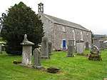 |
Key
The scheme for classifying buildings in Scotland is:
- Category A: "buildings of national or international importance, either architectural or historic; or fine, little-altered examples of some particular period, style or building type."[1]
- Category B: "buildings of regional or more than local importance; or major examples of some particular period, style or building type, which may have been altered."[1]
- Category C: "buildings of local importance; lesser examples of any period, style, or building type, as originally constructed or moderately altered; and simple traditional buildings which group well with other listed buildings."[1]
In March 2016 there were 47,288 listed buildings in Scotland. Of these, 8% were Category A, and 50% were Category B, with the remaining 42% being Category C.[2]
gollark: I like boreals, but they're caveblockers now...
gollark: 5/6 11/18... finding and locking myself with cool stuff is hard at silver...
gollark: I think so.
gollark: I like pink tinsels most.
gollark: Maybe some day, they'll fix the raffle system, and we can do that...
See also
Notes
- Sometimes known as OSGB36, the grid reference (where provided) is based on the British national grid reference system used by the Ordnance Survey.
• "Guide to National Grid". Ordnance Survey. Retrieved 2007-12-12.
• "Get-a-map". Ordnance Survey. Retrieved 2007-12-17. - Historic Environment Scotland assign a unique alphanumeric identifier to each designated site in Scotland, for listed buildings this always begins with "LB", for example "LB12345".
References
- All entries, addresses and coordinates are based on data from Historic Scotland. This data falls under the Open Government Licence
- "What is Listing?". Historic Environment Scotland. Retrieved 29 May 2018.
- Scotland's Historic Environment Audit 2016 (PDF). Historic Environment Scotland and the Built Environment Forum Scotland. pp. 15–16. Retrieved 29 May 2018.
This article is issued from Wikipedia. The text is licensed under Creative Commons - Attribution - Sharealike. Additional terms may apply for the media files.