List of listed buildings in Glamis, Angus
List
| Name | Location | Date Listed | Grid Ref. [note 1] | Geo-coordinates | Notes | LB Number [note 2] | Image |
|---|---|---|---|---|---|---|---|
| Arniefoul '1677' Cottage With Boundary Walls | 56°35′19″N 2°58′45″W | Category C(S) | 45670 |  | |||
| Bridgend Farm, Ice House | 56°37′08″N 3°01′00″W | Category C(S) | 45671 | | |||
| Deanbank Cottages With Boundary Wall | 56°37′01″N 3°01′03″W | Category B | 45672 | | |||
| Deanbank House With Railings And Gates | 56°37′00″N 3°00′58″W | Category C(S) | 45673 | | |||
| Glamis Castle Policies, Garden Statuary | 56°37′17″N 2°59′52″W | Category C(S) | 45679 | | |||
| Glamis House With Boundary Wall | 56°36′36″N 3°00′40″W | Category B | 45686 | | |||
| Glamis Village, The Square, Building To Nw Of Strathmore Arms Hotel | 56°36′31″N 3°00′15″W | Category B | 45708 | | |||
| Haughs Of Cossans Farmhouse | 56°38′02″N 2°58′33″W | Category C(S) | 45710 | | |||
| Mains Of Glamis Cottages With Boundary Walls | 56°37′04″N 2°59′20″W | Category C(S) | 45712 | | |||
| Mains Of Rochelhill Farmhouse With Boundary Walls | 56°35′40″N 3°01′09″W | Category B | 45714 | | |||
| Tarbrax Steading | 56°34′41″N 3°00′33″W | Category C(S) | 45720 | | |||
| Dryburn Farmhouse With Boundary Walls | 56°34′00″N 3°00′50″W | Category C(S) | 11672 | | |||
| Glamis Castle Policies, James Vi Statue | 56°37′10″N 3°00′10″W | Category B | 11708 | | |||
| Bridgend Bridge Over Dean Water | 56°37′06″N 3°00′52″W | Category B | 11712 | 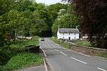 | |||
| Bridgend Farmhouse With Former Dairy, Ancillary Structures, Boundary Walls And Gatepiers | 56°37′09″N 3°00′54″W | Category B | 11713 | | |||
| Glamis Village, 6 And 8 Main Street, The Pewton Cottages, Between Foote's And Strapper's Close, Including Ancillary Structures | 56°36′30″N 3°00′15″W | Category B | 11572 | | |||
| Glamis Village, 7 Main Street, Between Steenie And Quoit Green Close | 56°36′30″N 3°00′17″W | Category B | 11575 | | |||
| Arniefoul, Sw Cottage With Ancillary Structures | 56°35′18″N 2°58′42″W | Category C(S) | 45669 | | |||
| Glamis Castle Policies, Earl Michael's (Garden) Bridge | 56°37′27″N 2°59′52″W | Category C(S) | 45676 | 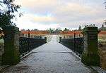 | |||
| Glamis Castle Policies, Ha-Ha | 56°37′09″N 3°00′11″W | Category C(S) | 45680 | | |||
| Glamis Castle Policies, The Warren With Ancillary Structures | 56°37′28″N 3°00′31″W | Category B | 45682 | | |||
| Glamis Village, Back Dykes, Gig House/Workshop To Rear Of 18 Main Street | 56°36′28″N 3°00′17″W | Category C(S) | 45687 | | |||
| Glamis Village, Braehead Road, Old Smithy | 56°36′28″N 3°00′08″W | Category C(S) | 45692 | | |||
| Glamis Village, Braehead Road, Woodfaulds Cottage With Ancillary Structures And Boundary Walls | 56°36′26″N 3°00′03″W | Category C(S) | 45693 | | |||
| Glamis Village, Kirkwynd, Parish Kirk, Graveyard, Walls And Gravestones | 56°36′34″N 3°00′05″W | Category B | 45694 | | |||
| Glamis Village, 15 Main Street | 56°36′30″N 3°00′19″W | Category C(S) | 45698 | | |||
| Glamis Village, Main Street, Corner House | 56°36′29″N 3°00′21″W | Category B | 45705 | | |||
| Hatton Of Ogilvie Farmhouse | 56°35′14″N 3°00′24″W | Category C(S) | 45709 | | |||
| Meikle Kilmundie Farmhouse | 56°34′42″N 2°59′22″W | Category C(S) | 45715 | | |||
| Nether Arniefoul Farmhouse, Steading, Cottage And Boundary Walls | 56°35′52″N 2°59′04″W | Category B | 45716 | | |||
| Tarbrax Bridge Over Glen Ogilvy Burn | 56°34′38″N 3°00′41″W | Category C(S) | 11669 | 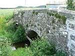 | |||
| Glamis Village, Braehead Road, Auld Mill Bridge Over Glamis Burn | 56°36′28″N 3°00′06″W | Category C(S) | 11696 | 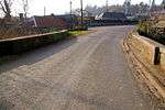 | |||
| Glamis Village, The Square, Old Market Cross | 56°36′30″N 3°00′12″W | Category C(S) | 11699 | | |||
| Glamis Castle Policies, Sundial | 56°37′11″N 3°00′06″W | Category A | 11705 | 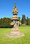 | |||
| Hunters Hill, Standing Stone Thornton | 56°36′25″N 2°59′21″W | Category B | 11715 | | |||
| Glamis Village, Kirkwynd, Angus Folk Museum, Former Hearse House And Cartshed And Granary With Boundary Walls | 56°36′34″N 3°00′12″W | Category C(S) | 11562 | | |||
| Glamis Village, 2 The Square, Strathmore Arms Hotel, Former Post Office House | 56°36′31″N 3°00′12″W | Category B | 11566 | | |||
| Glamis Village, 5 The Square, White House With Boundary Walls | 56°36′31″N 3°00′10″W | Category C(S) | 11568 | | |||
| Arniefoul, Se Cottage | 56°35′17″N 2°58′38″W | Category C(S) | 45668 | | |||
| Glamis Castle Policies, Dutch Garden With Boundary Walls, Gatepiers And Gates | 56°37′13″N 3°00′06″W | Category B | 45675 | | |||
| Glamis Castle Policies, The Parsonage | 56°37′26″N 3°00′37″W | Category C(S) | 45683 | | |||
| Glamis Village, To Rear Of 7 Main Street, Hanton's Yard, Old Jail | 56°36′31″N 3°00′16″W | Category C(S) | 45696 | | |||
| Glamis Village, To Rear Of 7 Main Street, Hanton's Yard, Workshop | 56°36′31″N 3°00′17″W | Category B | 45697 | | |||
| Glamis Village, 12 And 14 Main Street | 56°36′30″N 3°00′16″W | Category C(S) | 45702 | | |||
| Glamis Village, 24 Main Street | 56°36′29″N 3°00′19″W | Category B | 45704 | | |||
| Glamis Village, Main Street, The Washing Green, Water Pump And Well | 56°36′28″N 3°00′22″W | Category C(S) | 45706 | | |||
| 2 Plans Of Thornton, Greengate | 56°36′32″N 2°58′33″W | Category C(S) | 45718 | | |||
| Mains Of Rochelhill Dovecot | 56°35′38″N 3°01′10″W | Category A | 11670 | 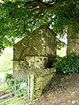 | |||
| Glamis Castle Policies, North Lodge (Gladiator) Gate | 56°37′15″N 3°00′56″W | Category B | 11700 | 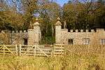 | |||
| Glamis Castle | 56°37′13″N 3°00′09″W | Category A | 11701 | 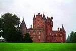 | |||
| Glamis Castle Policies, West Tower | 56°37′11″N 3°00′15″W | Category B | 11707 | 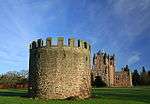 | |||
| Glamis Village, 6 And 7 The Square, Lairdie's Brae Houses | 56°36′30″N 3°00′12″W | Category B | 11570 | | |||
| Glamis Village, 10 Main Street, Between Strapper's Close And Greenhill's Close | 56°36′30″N 3°00′16″W | Category C(S) | 11573 | | |||
| Glamis Village, 26 Main Street With Ancillary Structure | 56°36′29″N 3°00′20″W | Category B | 11578 | | |||
| Glamis Castle, Polices, Game Larder | 56°37′15″N 3°00′03″W | Category C(S) | 45677 | | |||
| Glamis Castle Policies, Walled Garden | 56°37′30″N 2°59′56″W | Category B | 45684 | 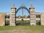 | |||
| Glamis Village, 17 Main Street | 56°36′29″N 3°00′19″W | Category C(S) | 45700 | | |||
| Glamis Village, 19 Main Street | 56°36′29″N 3°00′20″W | Category C(S) | 45701 | | |||
| Upper Hayston Farmhouse With Walled Garden, Boundary Walls, Gatepiers And Gates | 56°35′59″N 2°58′14″W | Category C(S) | 45711 | | |||
| Wester Denoon Dovecot | 56°34′31″N 3°03′50″W | Category B | 11671 | | |||
| Glamis Castle Policies, Dovecot | 56°36′48″N 3°00′18″W | Category A | 11710 | 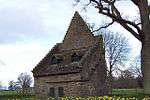 | |||
| Milton Mill, Detached Kiln And Stables | 56°34′58″N 3°00′17″W | Category B | 11724 | | |||
| Glamis Castle Polices, Kirk Gate | 56°36′36″N 3°00′06″W | Category B | 11558 | | |||
| Glamis Village, 1 The Square, Strathmore Arms Hotel | 56°36′31″N 3°00′13″W | Category B | 11565 | | |||
| Glamis Village, 4 The Square, Bakery House | 56°36′31″N 3°00′12″W | Category B | 11567 | | |||
| Glamis Village, 16 Main Street, Between Craig's Close And Nicol's Close | 56°36′29″N 3°00′17″W | Category B | 11577 | | |||
| Glamis Village, Dundee Road, Glamis Primary School With Playshed | 56°36′26″N 3°00′23″W | Category C(S) | 45690 | | |||
| Mains Of Glamis Steading | 56°36′57″N 2°59′24″W | Category B | 45713 | | |||
| Arniefoul Bridge Over Glamis Burn | 56°35′50″N 2°59′10″W | Category C(S) | 11723 | 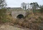 | |||
| Glamis Village, Kirkwynd, Parish Kirk Of St Fergus (Church Of Scotland) With Session House | 56°42′48″N 2°28′05″W | Category B | 11555 |  | |||
| Glamis Village, Kirkwynd, Parish Kirk Manse Including East Wall, Gatepiers, Gates And Boundary Walls | 56°36′35″N 3°00′08″W | Category B | 11559 | | |||
| Glamis Village, 6 Kirkwynd, Formerly Head Forester's House With Boundary Walls | 56°36′32″N 3°00′12″W | Category C(S) | 11564 | | |||
| Glamis Village, 1 Main Street | 56°36′31″N 3°00′14″W | Category B | 11574 | 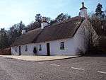 | |||
| Glamis Village, 20 Dundee Road, Strathmore Estates Office With Ancillary Structure And Gatepiers | 56°36′23″N 3°00′13″W | Category C(S) | 45689 | | |||
| Tarbrax Farmhouse With Ancillary Structure And Boundary Walls | 56°34′40″N 3°00′33″W | Category C(S) | 45719 | | |||
| Glamis Village, 20 And 22 Main Street | 56°36′29″N 3°00′18″W | Category B | 12381 | | |||
| Milton Mill Bridge Over Glen Ogilvy Burn | 56°34′55″N 3°00′19″W | Category C(S) | 11668 | | |||
| Glamis Village, Glamis Saw Mill, The Mill Slap | 56°36′23″N 3°00′07″W | Category C(S) | 11697 | | |||
| Glamis Castle Policies, Charles I Statue | 56°37′09″N 3°00′09″W | Category B | 11709 | | |||
| Glamis Village, Braehead Road, Masonic Hall, Lodge Glamis 99 With Boundary Walls | 56°36′30″N 3°00′09″W | Category C(S) | 11569 | | |||
| Arniefoul, Nw Cottage With Ancillary Structure | 56°35′18″N 2°58′42″W | Category C(S) | 45667 | | |||
| Glamis Village, Charleston Road And Kirriemuir Road, War Memorial With Plinth | 56°36′27″N 3°00′30″W | Category C(S) | 45688 | | |||
| Glamis Village, Dundee Road, Glamis Schoolhouse | 56°36′26″N 3°00′23″W | Category C(S) | 45691 | | |||
| Glamis Village, 18 Main Street, Between Craig's Close And Nicol's Close | 56°36′29″N 3°00′18″W | Category B | 45703 | | |||
| Glamis Village, 4 Braehead Road, Old Smiddy House With Boundary Walls | 56°36′30″N 3°00′10″W | Category B | 13770 | | |||
| Glamis Village, Braehead Road, The Auld Mill And Joiner's Workshop | 56°36′29″N 3°00′07″W | Category B | 13771 | | |||
| Glamis Castle Policies, North Bridge | 56°37′26″N 3°00′04″W | Category B | 11702 | 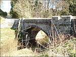 | |||
| Glamis Castle Policies, Icehouse | 56°36′59″N 2°59′50″W | Category C(S) | 11704 | | |||
| Glamis Castle Policies, Earl John Bridge | 56°37′12″N 3°00′25″W | Category B | 11711 | | |||
| Glamis Castle Policies, Garden House | 56°37′31″N 3°00′03″W | Category B | 45678 | | |||
| Glamis Castle Policies, Italian Garden | 56°37′14″N 2°59′57″W | Category B | 45681 | 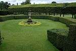 | |||
| Glamis Village, 8 And 9 The Square, Post Office, Lairdie's Brae Houses, With Ancillary Structures | 56°36′30″N 3°00′12″W | Category B | 45707 | | |||
| Nether Hayston Farmhouse | 56°36′21″N 2°57′26″W | Category B | 45717 | | |||
| Glamis Castle Policies, Mains Bridge (East) | 56°37′07″N 2°59′49″W | Category C(S) | 13780 | | |||
| Glamis Castle Policies, Main Gate (South Lodge) | 56°36′29″N 3°00′31″W | Category B | 11698 | | |||
| Glamis Castle Policies, East Tower | 56°37′09″N 3°00′04″W | Category B | 11706 | | |||
| Glamis Village, Kirkwynd, Parish Kirk, Strathmore Aisle | 56°36′34″N 3°00′04″W | Category A | 11556 | | |||
| Glamis Village, Kirkwynd, Angus Folk Museum | 56°36′33″N 3°00′11″W | Category B | 11563 | 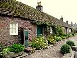 | |||
| Glamis Village, 2 Main Street, Heritage Centre, East Of Foote's Close | 56°36′30″N 3°00′14″W | Category C(S) | 11571 | | |||
| Glamis Village, 9 - 13 (Odd Nos) Main Street Between Quoit Green Close And Blackadder Square | 56°36′30″N 3°00′18″W | Category B | 11576 | | |||
| Glamis Village, 6 Braehead Road, Auld Mill House | 56°36′30″N 3°00′08″W | Category B | 11580 | |
Key
The scheme for classifying buildings in Scotland is:
- Category A: "buildings of national or international importance, either architectural or historic; or fine, little-altered examples of some particular period, style or building type."[1]
- Category B: "buildings of regional or more than local importance; or major examples of some particular period, style or building type, which may have been altered."[1]
- Category C: "buildings of local importance; lesser examples of any period, style, or building type, as originally constructed or moderately altered; and simple traditional buildings which group well with other listed buildings."[1]
In March 2016 there were 47,288 listed buildings in Scotland. Of these, 8% were Category A, and 50% were Category B, with the remaining 42% being Category C.[2]
gollark: ¿?
gollark: SKYNETCHAT
gollark: Though since krist has public transactions, I guess you can enforce compliance via checking to ensure that all money on, I don't know, a registered name address, goes to the share address.
gollark: Why do you need much else?
gollark: Are you sure it couldn't just be* send money → share address* share address holds money until it's a multiple of (number of shares)* distribute money → share addresses
See also
Notes
- Sometimes known as OSGB36, the grid reference (where provided) is based on the British national grid reference system used by the Ordnance Survey.
• "Guide to National Grid". Ordnance Survey. Retrieved 2007-12-12.
• "Get-a-map". Ordnance Survey. Retrieved 2007-12-17. - Historic Environment Scotland assign a unique alphanumeric identifier to each designated site in Scotland, for listed buildings this always begins with "LB", for example "LB12345".
References
- All entries, addresses and coordinates are based on data from Historic Scotland. This data falls under the Open Government Licence
- "What is Listing?". Historic Environment Scotland. Retrieved 29 May 2018.
- Scotland's Historic Environment Audit 2016 (PDF). Historic Environment Scotland and the Built Environment Forum Scotland. pp. 15–16. Retrieved 29 May 2018.
This article is issued from Wikipedia. The text is licensed under Creative Commons - Attribution - Sharealike. Additional terms may apply for the media files.