List of listed buildings in Gladsmuir, East Lothian
List
| Name | Location | Date Listed | Grid Ref. [note 1] | Geo-coordinates | Notes | LB Number [note 2] | Image |
|---|---|---|---|---|---|---|---|
| Samuelston Bridge[1] | 55°55′45″N 2°49′00″W[2]) | Category B | 13186 | 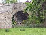 | |||
| Samuelston West Mains Cottage | 55°55′39″N 2°50′09″W | Category C(S) | 13190 |  | |||
| Harelaw Cottages | 55°58′53″N 2°52′28″W | Category C(S) | 13152 | | |||
| Harelaw Steading | 55°58′46″N 2°52′53″W | Category B | 13155 | | |||
| 3-6 Inclusive Nos Longniddry Farm Cottages | 55°58′28″N 2°53′32″W | Category C(S) | 13158 | | |||
| Longniddry Farm Steading | 55°58′25″N 2°53′33″W | Category B | 13160 | | |||
| Longniddry 3 And 4, 13 And 14 Kitchener Crescent | 55°58′32″N 2°53′32″W | Category B | 13165 | | |||
| Longniddry 5 And 6, 11 And 12, 15 And 16, 17 And 18 Kitchener Crescent | 55°58′34″N 2°53′28″W | Category B | 13166 | | |||
| Longniddry Lyars Road Woodburn | 55°59′00″N 2°53′44″W | Category C(S) | 13167 | | |||
| Longniddry 11 Main Street Roselea | 55°58′28″N 2°53′43″W | Category C(S) | 13173 | | |||
| Gladsmuir Dragonswell With Garden Building | 55°57′00″N 2°52′07″W | Category B | 12705 | | |||
| Penston Farmhouse | 55°56′25″N 2°53′31″W | Category C(S) | 13180 | | |||
| Setonhill With Dovecot Walled Garden And Gatepiers | 55°58′29″N 2°51′58″W | Category B | 13191 | | |||
| Longniddry 1 And 2 Kitchener Crescent | 55°58′31″N 2°53′33″W | Category B | 13163 | | |||
| Longniddry Mains, Cottages And Steading | 55°58′23″N 2°53′51″W | Category C(S) | 13168 | | |||
| Longniddry, 25 Kings Road, West Court Including Garages And Entrance Forecourt | 55°58′26″N 2°54′34″W | Category C(S) | 51780 | | |||
| Longniddry Main Street Grainfoot | 55°58′28″N 2°53′44″W | Category C(S) | 13175 | | |||
| Longniddry School | 55°58′36″N 2°53′33″W | Category B | 13179 | | |||
| Longniddry 7 And 8, 9 And 10 Kitchener Crescent | 55°58′33″N 2°53′31″W | Category B | 13164 | | |||
| Longniddry 7 Main Street | 55°58′28″N 2°53′40″W | Category C(S) | 13170 | | |||
| Chesterhall Farmhouse | 55°57′44″N 2°54′46″W | Category B | 12700 | | |||
| Elvingston House With Stable Court | 55°57′34″N 2°51′51″W | Category B | 12702 | | |||
| Elvingston House Dovecot | 55°57′35″N 2°51′49″W | Category B | 12703 | | |||
| Gladsmuir Farmhouse With Steading | 55°56′58″N 2°52′04″W | Category B | 12706 | | |||
| Gladsmuir Schoolhouse And Former School | 55°56′58″N 2°52′14″W | Category C(S) | 12710 | | |||
| Redcoll Gate Lodge And Gatepiers | 55°57′53″N 2°53′17″W | Category B | 13183 | | |||
| Redcoll Steading Nw Range With Dovecot | 55°58′03″N 2°52′57″W | Category B | 13184 | | |||
| Samuelston East Mains Farmhouse | 55°55′46″N 2°49′27″W | Category C(S) | 13188 | | |||
| Setonhill Cartshed And Granary | 55°58′29″N 2°52′00″W | Category C(S) | 13192 | | |||
| Redcoll | 55°58′00″N 2°53′05″W | Category B | 13143 | | |||
| Longniddry House With Outbuilding Garden Walls Wellhead And_Kirk Ruin | 55°58′23″N 2°53′58″W | Category B | 13162 | | |||
| Elvingston House South Lodge Gatepiers And Quadrant Wall | 55°57′03″N 2°51′35″W | Category C(S) | 12704 | | |||
| Gladsmuir Garage Cottage | 55°56′57″N 2°52′12″W | Category C(S) | 12707 | | |||
| Gladsmuir Old Parish Church With Graveyard Walls | 55°57′00″N 2°52′11″W | Category B | 12708 | | |||
| Greendykes Farmhouse | 55°57′10″N 2°54′14″W | Category C(S) | 12712 | | |||
| Longniddry Main Street Longniddry Inn | 55°58′29″N 2°53′39″W | Category C(S) | 13176 | | |||
| Redcoll Cottages | 55°58′13″N 2°52′59″W | Category C(S) | 13182 | | |||
| Samuelston Mid Mains Cottage | 55°55′43″N 2°49′45″W | Category C(S) | 13189 | | |||
| Trabroun Steading With Dovecot | 55°57′32″N 2°51′27″W | Category B | 13194 | | |||
| Landridge Lime Kilns | 55°58′09″N 2°52′16″W | Category C(S) | 13156 | | |||
| Longniddry Gosford Road Harmony | 55°58′53″N 2°53′44″W | Category B | 13161 | | |||
| Longniddry 14 And 15 Main Street | 55°58′29″N 2°53′35″W | Category C(S) | 13174 | | |||
| Gladsmuir Parish Church With Graveyard Gatepiers And Gates | 55°56′58″N 2°52′10″W | Category B | 12709 | | |||
| Gosford Gateway West Lodge And Policy Walls | 55°58′45″N 2°53′22″W | Category A | 12711 | 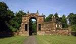 | |||
| Redcoll Carriage House | 55°58′01″N 2°53′01″W | Category B | 13181 | | |||
| Southfield House With Gatepiers | 55°57′49″N 2°53′32″W | Category B | 13193 | | |||
| Harelaw Lime Kilns | 55°58′38″N 2°53′00″W | Category C(S) | 13154 | | |||
| Longniddry The Dean | 55°58′24″N 2°54′39″W | Category B | 13157 | | |||
| Longniddry Farmhouse | 55°58′24″N 2°53′35″W | Category B | 13159 | | |||
| Coates Cartshed And Granary | 55°58′22″N 2°50′22″W | Category C(S) | 12701 | | |||
| Elvingston House East Lodge With Gatepiers | 55°57′36″N 2°51′39″W | Category B | 13838 | | |||
| Longniddry 12 Old School Road | 55°58′28″N 2°53′43″W | Category C(S) | 13177 | | |||
| Longniddry 8 Main Street | 55°58′28″N 2°53′42″W | Category C(S) | 13171 | | |||
| Longniddry 9 And 10 Main Street | 55°58′28″N 2°53′42″W | Category C(S) | 13172 | | |||
| Longniddry Old School Road Greydykes | 55°58′29″N 2°53′45″W | Category C(S) | 13178 | | |||
| Redhouse Farmhouse With Retaining Wall | 55°58′59″N 2°51′46″W | Category C(S) | 13185 | | |||
| Samuelston East Mains | 55°55′44″N 2°49′33″W | Category C(S) | 13187 | | |||
| Greendykes Steading | 55°57′14″N 2°54′12″W | Category B | 13151 | | |||
| Harelaw Farmhouse | 55°58′47″N 2°52′52″W | Category B | 13153 | | |||
| Longniddry Main Street Reading Room | 55°58′26″N 2°53′44″W | Category C(S) | 13169 | |
Key
The scheme for classifying buildings in Scotland is:
- Category A: "buildings of national or international importance, either architectural or historic; or fine, little-altered examples of some particular period, style or building type."[4]
- Category B: "buildings of regional or more than local importance; or major examples of some particular period, style or building type, which may have been altered."[4]
- Category C: "buildings of local importance; lesser examples of any period, style, or building type, as originally constructed or moderately altered; and simple traditional buildings which group well with other listed buildings."[4]
In March 2016 there were 47,288 listed buildings in Scotland. Of these, 8% were Category A, and 50% were Category B, with the remaining 42% being Category C.[5]
gollark: MOSFETs in 1959.
gollark: Ah, transistors are 1947.
gollark: Technologies have a lot of prerequisites.
gollark: They wouldn't just use worse technology for no particular reason, mostly.
gollark: The people in the past *were actually quite smart*.
Notes
- Sometimes known as OSGB36, the grid reference (where provided) is based on the British national grid reference system used by the Ordnance Survey.
• "Guide to National Grid". Ordnance Survey. Retrieved 2007-12-12.
• "Get-a-map". Ordnance Survey. Retrieved 2007-12-17. - Historic Environment Scotland assign a unique alphanumeric identifier to each designated site in Scotland, for listed buildings this always begins with "LB", for example "LB12345".
References
- All entries, addresses and coordinates are based on data from Historic Scotland. This data falls under the Open Government Licence
- Stuff, Good. "Samuelston Bridge, Gladsmuir, East Lothian". britishlistedbuildings.co.uk.
- Stuff, Good. "Samuelston Bridge, Gladsmuir, East Lothian". britishlistedbuildings.co.uk.
- Stuff, Good. "Samuelston Bridge, Gladsmuir, East Lothian". britishlistedbuildings.co.uk.
- "What is Listing?". Historic Environment Scotland. Retrieved 29 May 2018.
- Scotland's Historic Environment Audit 2016 (PDF). Historic Environment Scotland and the Built Environment Forum Scotland. pp. 15–16. Retrieved 29 May 2018.
This article is issued from Wikipedia. The text is licensed under Creative Commons - Attribution - Sharealike. Additional terms may apply for the media files.