List of listed buildings in Galston, East Ayrshire
List
| Name | Location | Date Listed | Grid Ref. [note 1] | Geo-coordinates | Notes | LB Number [note 2] | Image |
|---|---|---|---|---|---|---|---|
| R.C. Church Of St. Sophia | 55°35′57″N 4°22′40″W | Category A | 32010 | 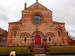 | |||
| Barr Tower | 55°35′54″N 4°22′47″W | Category B | 32012 |  | |||
| Portland Arms Hotel | 55°36′02″N 4°22′54″W | Category B | 32014 | | |||
| Nos. 4-24 (Even Numbers) Polworth Street | 55°36′03″N 4°22′48″W | Category C(S) | 32018 | | |||
| Lodge, Lanfine (Opposite The Green) | 55°36′20″N 4°19′13″W | Category B | 13827 | | |||
| Row Of Cottages, Priestland - (Pal Myra) (Roseside) (Lynedoch) | 55°36′34″N 4°15′33″W | Category C(S) | 12570 | | |||
| 34 Wallace Street With Boundary Wall And Gatepiers | 55°35′57″N 4°22′46″W | Category B | 48208 | | |||
| Nos. 33 And 35 Bridge Street (Hugh H. Neil, Grocer) | 55°36′01″N 4°22′48″W | Category C(S) | 32017 | | |||
| Greenbank | 55°36′28″N 4°16′00″W | Category C(S) | 12571 | | |||
| Avon Bridge | 55°36′01″N 4°11′42″W | Category B | 12572 | | |||
| Old Galston Church And Graveyard | 55°36′03″N 4°22′56″W | Category B | 32009 |  | |||
| Parkeston Farm | 55°35′54″N 4°19′06″W | Category C(S) | 12569 | | |||
| Allanton | 55°36′33″N 4°13′22″W | Category C(S) | 12573 | | |||
| Glebe Road, Galston Primary School Main Block, Including Gates, Gatepiers, Railings And Boundary Walls | 55°35′53″N 4°22′55″W | Category B | 44603 | | |||
| Nos. 14-28 (Even Numbers) Titchfield Street | 55°36′05″N 4°23′01″W | Category C(S) | 32019 | | |||
| U.F. Church Wallace Street | 55°35′56″N 4°22′49″W | Category B | 32011 | | |||
| Lanfine Estate, Walled Garden With Former Potting Sheds | 55°36′05″N 4°17′35″W | Category C(S) | 50120 | | |||
| Galston Bridge | 55°36′06″N 4°22′48″W | Category B | 32013 | | |||
| R.A. Hutchison & Co | 55°36′02″N 4°22′53″W | Category B | 32015 | | |||
| Lanfine House | 55°36′04″N 4°18′05″W | Category B | 13826 | | |||
| Dovecote, Lanfine Policies | 55°36′03″N 4°18′09″W | Category B | 12564 | | |||
| Bridge, In Lanfine Park | 55°36′03″N 4°17′51″W | Category B | 12565 | | |||
| Burnhead | 55°35′52″N 4°13′01″W | Category C(S) | 12574 | | |||
| Glebe Road (East Side), Galston Primary School Infant Block, Including Gates, Gatepiers, Boundary Walls & Railings | 55°35′54″N 4°22′52″W | Category C(S) | 49189 | | |||
| Co-Operative Society Building, 4-12 (Even Nos) Brewland Street | 55°36′01″N 4°22′55″W | Category B | 32020 | | |||
| Nos. 4 & 6 Bridge Street | 55°36′02″N 4°22′52″W | Category C(S) | 32016 | | |||
| Lodge, Lanfine (Opposite Townhead) | 55°36′18″N 4°18′42″W | Category B | 12567 | | |||
| Bruntwood | 55°33′54″N 4°22′21″W | Category B | 12575 | | |||
| Cairnhill Farm | 55°34′42″N 4°20′15″W | Category C(S) | 12576 | | |||
| Holmes House Steading, Horse Engine House | 55°35′55″N 4°25′07″W | Category C(S) | 49579 | | |||
| Bridge, Greenbank | 55°36′30″N 4°15′42″W | Category C(S) | 13828 | | |||
| Cessnock Castle | 55°35′26″N 4°21′53″W | Category A | 12562 | | |||
| Gateway, Causeyfoot | 55°35′31″N 4°22′05″W | Category B | 12563 | | |||
| Lodge, Lanfine (Opposite Ranoldcoup Bridge) | 55°36′20″N 4°16′54″W | Category B | 12566 | | |||
| Waterhaughs | 55°36′20″N 4°17′32″W | Category B | 12568 | | |||
| Sornhill Farm | 55°34′41″N 4°21′57″W | Category A | 13829 | |
Key
The scheme for classifying buildings in Scotland is:
- Category A: "buildings of national or international importance, either architectural or historic; or fine, little-altered examples of some particular period, style or building type."[1]
- Category B: "buildings of regional or more than local importance; or major examples of some particular period, style or building type, which may have been altered."[1]
- Category C: "buildings of local importance; lesser examples of any period, style, or building type, as originally constructed or moderately altered; and simple traditional buildings which group well with other listed buildings."[1]
In March 2016 there were 47,288 listed buildings in Scotland. Of these, 8% were Category A, and 50% were Category B, with the remaining 42% being Category C.[2]
gollark: I mean, if you breed your dragons half as much and they give twice as many rares, does it matter much?
gollark: Except over time it probably works out the same.
gollark: <@246500785368596480> ?????
gollark: *should probably have kept double Z cheese*
gollark: 3 coppers for a cheese? *Wow*.
Notes
- Sometimes known as OSGB36, the grid reference (where provided) is based on the British national grid reference system used by the Ordnance Survey.
• "Guide to National Grid". Ordnance Survey. Retrieved 12 December 2007.
• "Get-a-map". Ordnance Survey. Retrieved 17 December 2007. - Historic Environment Scotland assign a unique alphanumeric identifier to each designated site in Scotland, for listed buildings this always begins with "LB", for example "LB12345".
References
- All entries, addresses and coordinates are based on data from Historic Scotland. This data falls under the Open Government Licence
- "What is Listing?". Historic Environment Scotland. Retrieved 29 May 2018.
- Scotland's Historic Environment Audit 2016 (PDF). Historic Environment Scotland and the Built Environment Forum Scotland. pp. 15–16. Retrieved 29 May 2018.
This article is issued from Wikipedia. The text is licensed under Creative Commons - Attribution - Sharealike. Additional terms may apply for the media files.